
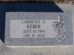
Lawrence Edward “Larry” Keber
| Birth | : | 10 Sep 1914 Primrose, Boone County, Nebraska, USA |
| Death | : | 12 Apr 2001 Spalding, Greeley County, Nebraska, USA |
| Burial | : | Blackpool Cemetery and Crematorium, Poulton-le-Fylde, Wyre Borough, England |
| Coordinate | : | 53.8465680, -3.0196600 |
| Description | : | SPALDING — Lawrence E. "Larry" Keber, 86, of Spalding died Thursday, April 12, 2001, at the Friendship Villa in Spalding. Services will be at 10:30 a.m. Tuesday at St. Michael's Catholic Church in Spalding. The Rev. Joe Hannappel will officiate. Burial will be in St. Michael's Cemetery. Visitation will be from 3 to 9 p.m. Monday at the church with rosaries at 4:30 and 8 p.m. Dolce Scheef Mortuary in Spalding is in charge of arrangements. Mr. Keber was born Sept. 10, 1914, to Clemens and Anna (Glaser) Keber at Primrose. In 1919, the Kebers moved... Read More |
frequently asked questions (FAQ):
-
Where is Lawrence Edward “Larry” Keber's memorial?
Lawrence Edward “Larry” Keber's memorial is located at: Blackpool Cemetery and Crematorium, Poulton-le-Fylde, Wyre Borough, England.
-
When did Lawrence Edward “Larry” Keber death?
Lawrence Edward “Larry” Keber death on 12 Apr 2001 in Spalding, Greeley County, Nebraska, USA
-
Where are the coordinates of the Lawrence Edward “Larry” Keber's memorial?
Latitude: 53.8465680
Longitude: -3.0196600
Family Members:
Parent

Spouse
Siblings
Children
Flowers:


Nearby Cemetories:
1. Blackpool Cemetery and Crematorium
Poulton-le-Fylde, Wyre Borough, England
Coordinate: 53.8465680, -3.0196600
2. All Hallow's Churchyard
Bispham, Blackpool Unitary Authority, England
Coordinate: 53.8567580, -3.0372160
3. Saint Chad Churchyard
Poulton-le-Fylde, Wyre Borough, England
Coordinate: 53.8471992, -2.9925005
4. Blackpool Jewish Cemetery
Blackpool, Blackpool Unitary Authority, England
Coordinate: 53.8287397, -3.0311753
5. St Stephen On-the-Cliffs Churchyard
Blackpool, Blackpool Unitary Authority, England
Coordinate: 53.8407230, -3.0515610
6. St Johns Roman Catholic Church Cemetery
Poulton-le-Fylde, Wyre Borough, England
Coordinate: 53.8520854, -2.9873511
7. Layton Cemetery
Blackpool, Blackpool Unitary Authority, England
Coordinate: 53.8273740, -3.0328240
8. St Paul's Church & Medical Centre
Blackpool Unitary Authority, England
Coordinate: 53.8291540, -3.0533490
9. Poulton-Le-Fylde Old Cemetery
Poulton-le-Fylde, Wyre Borough, England
Coordinate: 53.8458145, -2.9713324
10. Poulton New Cemetery
Poulton-le-Fylde, Wyre Borough, England
Coordinate: 53.8461240, -2.9689560
11. Christ Church Thornton Churchyard
Thornton-Cleveleys, Wyre Borough, England
Coordinate: 53.8772800, -3.0221100
12. St John the Evangelist Churchyard
Blackpool, Blackpool Unitary Authority, England
Coordinate: 53.8182303, -3.0508197
13. Carlton Cemetery& Crematorium
Blackpool, Blackpool Unitary Authority, England
Coordinate: 53.8095921, -3.0364920
14. Saint Paul Churchyard
Great Marton, Blackpool Unitary Authority, England
Coordinate: 53.8053220, -3.0268330
15. Marton Burial Ground
Great Marton, Blackpool Unitary Authority, England
Coordinate: 53.8030870, -3.0108350
16. St. Anne's Churchyard
Blackburn, Blackburn with Darwen Unitary Authority, England
Coordinate: 53.8381160, -2.9362870
17. St Anne Churchyard
Singleton, Fylde Borough, England
Coordinate: 53.8379280, -2.9359890
18. Holy Trinity Churchyard
Blackpool, Blackpool Unitary Authority, England
Coordinate: 53.7962949, -3.0536214
19. St James Churchyard
Stalmine, Wyre Borough, England
Coordinate: 53.9020510, -2.9533720
20. St Michael Churchyard
Weeton, Fylde Borough, England
Coordinate: 53.7995380, -2.9358020
21. Preesall Cemetery
Preesall, Wyre Borough, England
Coordinate: 53.9075410, -2.9635410
22. Fleetwood Cemetery
Fleetwood, Wyre Borough, England
Coordinate: 53.9223440, -3.0370570
23. St. Peter and St. David Churchyard
Fleetwood, Wyre Borough, England
Coordinate: 53.9238123, -3.0116212
24. St. John’s Churchyard
Out Rawcliffe, Wyre Borough, England
Coordinate: 53.8741650, -2.8959310