
| Birth | : | 13 Jan 1894 Cole County, Missouri, USA |
| Death | : | 18 Apr 1918 Jackson County, Missouri, USA |
| Burial | : | Matheis Cemetery, Russellville, Cole County, USA |
| Coordinate | : | 38.4571800, -92.4491600 |
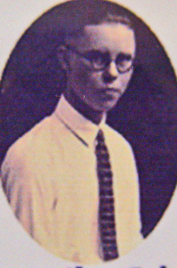
| Description | : | information per death certificate Son of Elijah A. and Missouri "Kate" (Carney) Enloe The Eldon Advertiser, April 25, 1918 Lawrence Enloe was born Jan. 13, 1894, died April 18, 1918. He was the son of E.A. (Lige) Enloe who resides about three miles east and south of Enon. At the time of his death he was in Kansas City where he lived with his sister, Mrs. Scrivner. His death was caused by complications following pneumonia. Lawrence had lived all his life in this community and was known for his honesty and his kindness. He was a devout Christian,... Read More |
frequently asked questions (FAQ):
-
Where is Lawrence Enloe's memorial?
Lawrence Enloe's memorial is located at: Matheis Cemetery, Russellville, Cole County, USA.
-
When did Lawrence Enloe death?
Lawrence Enloe death on 18 Apr 1918 in Jackson County, Missouri, USA
-
Where are the coordinates of the Lawrence Enloe's memorial?
Latitude: 38.4571800
Longitude: -92.4491600
Family Members:
Parent

Siblings
Flowers:


Nearby Cemetories:
1. Roark Cemetery
Russellville, Cole County, USA
Coordinate: 38.4696999, -92.4255981
2. Campbell Cemetery
Cole County, USA
Coordinate: 38.4810982, -92.4297028
3. Enon Cemetery
Russellville, Cole County, USA
Coordinate: 38.4888992, -92.4730988
4. Belleville Cemetery
Russellville, Cole County, USA
Coordinate: 38.4970490, -92.4667150
5. Clibourn Cemetery
Russellville, Cole County, USA
Coordinate: 38.4760500, -92.3973500
6. Trinity Lutheran Cemetery
Russellville, Cole County, USA
Coordinate: 38.5028000, -92.4317017
7. Saint Michael Cemetery
Russellville, Cole County, USA
Coordinate: 38.5109300, -92.4429100
8. Enloe Cemetery
Moniteau County, USA
Coordinate: 38.5074997, -92.4741974
9. Rock Enon Cemetery
Miller County, USA
Coordinate: 38.4668400, -92.5170700
10. Bruce-Lewis-McGahan Cemetery
Enon, Moniteau County, USA
Coordinate: 38.4667500, -92.5172100
11. Buckner Russell Cemetery
Cole County, USA
Coordinate: 38.5136900, -92.4359390
12. Karnes-Carney-Henderson Cemetery
Burris Fork, Moniteau County, USA
Coordinate: 38.4992100, -92.5007510
13. Allen Cemetery
Olean, Miller County, USA
Coordinate: 38.4150009, -92.5008011
14. Evangelical Lutheran Cemetery One Acre
Russellville, Cole County, USA
Coordinate: 38.5175667, -92.4415817
15. Mount Carmel Cemetery
Brazito, Cole County, USA
Coordinate: 38.4398499, -92.3734207
16. Russellville Cemetery
Russellville, Cole County, USA
Coordinate: 38.5196991, -92.4366989
17. Jackson Chapel Methodist Church Cemetery
California, Moniteau County, USA
Coordinate: 38.4447900, -92.5286500
18. Farmer Cemetery
Hickory Hill, Cole County, USA
Coordinate: 38.4143500, -92.3889790
19. Duncan-Berry Family Cemetery
Eugene, Cole County, USA
Coordinate: 38.4255555, -92.3761111
20. Blank Cemetery
Russellville, Cole County, USA
Coordinate: 38.5203018, -92.4180984
21. Spring Garden Cemetery
Spring Garden, Miller County, USA
Coordinate: 38.3922005, -92.4111023
22. Farris Cemetery
Moniteau County, USA
Coordinate: 38.4369900, -92.5380000
23. Gray Cemetery
Moniteau County, USA
Coordinate: 38.4536018, -92.5456009
24. Colvin Strong Cemetery
Millbrook, Cole County, USA
Coordinate: 38.5025600, -92.3690400