
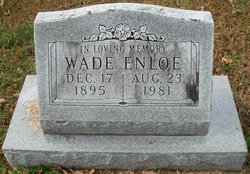
Wade Enloe
| Birth | : | 17 Dec 1895 |
| Death | : | 23 Aug 1981 |
| Burial | : | St. Mary's Churchyard, Witney, West Oxfordshire District, England |
| Coordinate | : | 51.7807116, -1.4850508 |
frequently asked questions (FAQ):
-
Where is Wade Enloe's memorial?
Wade Enloe's memorial is located at: St. Mary's Churchyard, Witney, West Oxfordshire District, England.
-
When did Wade Enloe death?
Wade Enloe death on 23 Aug 1981 in
-
Where are the coordinates of the Wade Enloe's memorial?
Latitude: 51.7807116
Longitude: -1.4850508
Family Members:
Parent

Spouse
Siblings

Flowers:


Nearby Cemetories:
1. St. Mary's Churchyard
Witney, West Oxfordshire District, England
Coordinate: 51.7807116, -1.4850508
2. St Mary Churchyard
Cogges, West Oxfordshire District, England
Coordinate: 51.7839280, -1.4782010
3. Tower Hill Cemetery
Witney, West Oxfordshire District, England
Coordinate: 51.7852950, -1.4999610
4. Woodgreen (Holy Trinity) Churchyard
West Oxfordshire District, England
Coordinate: 51.7918400, -1.4793500
5. St. Bartholomew Churchyard
Ducklington, West Oxfordshire District, England
Coordinate: 51.7658689, -1.4810340
6. St John The Baptist
Curbridge, West Oxfordshire District, England
Coordinate: 51.7764570, -1.5203140
7. St John the Evangelist
Hailey, West Oxfordshire District, England
Coordinate: 51.8107740, -1.4879260
8. St Peter's Churchyard
Crawley, West Oxfordshire District, England
Coordinate: 51.8069700, -1.5100400
9. St. James the Great Churchyard
South Leigh, West Oxfordshire District, England
Coordinate: 51.7781050, -1.4298950
10. Saint Kenelm's Churchyard
Minster Lovell, West Oxfordshire District, England
Coordinate: 51.8000620, -1.5314550
11. St Mary Churchyard
North Leigh, West Oxfordshire District, England
Coordinate: 51.8201820, -1.4396170
12. St. Britius Churchyard Extension
Brize Norton, West Oxfordshire District, England
Coordinate: 51.7660800, -1.5662600
13. St. Britius Churchyard
Brize Norton, West Oxfordshire District, England
Coordinate: 51.7662000, -1.5667000
14. St James's Church
Ramsden, West Oxfordshire District, England
Coordinate: 51.8340622, -1.4841064
15. Cote Baptist Chapel
Cote, West Oxfordshire District, England
Coordinate: 51.7254430, -1.4929510
16. St. James the Great Churchyard
Aston, West Oxfordshire District, England
Coordinate: 51.7252620, -1.5059510
17. St Mary the Virgin Churchyard
Freeland, West Oxfordshire District, England
Coordinate: 51.8116300, -1.4004700
18. St. Giles' Churchyard
Standlake, West Oxfordshire District, England
Coordinate: 51.7299550, -1.4262300
19. St Michael's Churchyard
Stanton Harcourt, West Oxfordshire District, England
Coordinate: 51.7480000, -1.3977000
20. Saint Michaels and All Angels Churchyard
Leafield, West Oxfordshire District, England
Coordinate: 51.8355550, -1.5390810
21. Bampton Cemetery
Bampton, West Oxfordshire District, England
Coordinate: 51.7296400, -1.5490200
22. St Nicholas Parish Church
Asthall, West Oxfordshire District, England
Coordinate: 51.8003600, -1.5850500
23. Holy Trinity Churchyard
Finstock, West Oxfordshire District, England
Coordinate: 51.8459910, -1.4801260
24. St. Mary the Virgin Churchyard
Bampton, West Oxfordshire District, England
Coordinate: 51.7278250, -1.5487270