
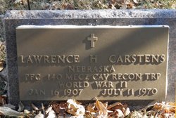
Lawrence Herman Carstens
| Birth | : | 16 Jan 1907 Pierce, Pierce County, Nebraska, USA |
| Death | : | 11 Jul 1970 Norfolk, Madison County, Nebraska, USA |
| Burial | : | New Union United Methodist Church Cemetery, Asheboro, Randolph County, USA |
| Coordinate | : | 35.6736920, -79.8880540 |
| Plot | : | Blk 30, Lot 1, Grv 345 |
| Description | : | Spouse: Betty Teadtke Veteran, Nebraska PFC 140 Mecz Cav Recon Trp, WW-II |
frequently asked questions (FAQ):
-
Where is Lawrence Herman Carstens's memorial?
Lawrence Herman Carstens's memorial is located at: New Union United Methodist Church Cemetery, Asheboro, Randolph County, USA.
-
When did Lawrence Herman Carstens death?
Lawrence Herman Carstens death on 11 Jul 1970 in Norfolk, Madison County, Nebraska, USA
-
Where are the coordinates of the Lawrence Herman Carstens's memorial?
Latitude: 35.6736920
Longitude: -79.8880540
Family Members:
Parent

Spouse

Siblings
Children
Flowers:


Nearby Cemetories:
1. New Union United Methodist Church Cemetery
Asheboro, Randolph County, USA
Coordinate: 35.6736920, -79.8880540
2. Andrew Balfour Family Cemetery
Cedar Grove, Randolph County, USA
Coordinate: 35.6436005, -79.9005966
3. Back Creek Friends Meeting Cemetery
Asheboro, Randolph County, USA
Coordinate: 35.7065063, -79.8921153
4. West Chapel United Methodist Church Cemetery
Asheboro, Randolph County, USA
Coordinate: 35.6981560, -79.8602220
5. Hopewell Friends Meeting Cemetery
Asheboro, Randolph County, USA
Coordinate: 35.6390840, -79.8765500
6. Rock Hill Primitive Baptist Cemetery
Asheboro, Randolph County, USA
Coordinate: 35.6920480, -79.8466140
7. Science Hill Friends Meeting Cemetery
Asheboro, Randolph County, USA
Coordinate: 35.6554090, -79.9310680
8. West Bend United Methodist Church Cemetery
Asheboro, Randolph County, USA
Coordinate: 35.6872610, -79.8345780
9. Sawyersville Wesleyan Church Cemetery
Asheboro, Randolph County, USA
Coordinate: 35.7155790, -79.9107290
10. Oaklawn Cemetery
Asheboro, Randolph County, USA
Coordinate: 35.6885986, -79.8246994
11. Saint Mark's United Methodist Church
Cedar Grove, Randolph County, USA
Coordinate: 35.6454300, -79.9484300
12. First Presbyterian Church Columbarium
Asheboro, Randolph County, USA
Coordinate: 35.6912790, -79.8196490
13. Charlotte United Methodist Church Cemetery
Asheboro, Randolph County, USA
Coordinate: 35.7317772, -79.8685226
14. Episcopal Church of Good Shepherd Memorial Garden
Asheboro, Randolph County, USA
Coordinate: 35.7152410, -79.8327260
15. Smyrna Grove Community Church Cemetery
Asheboro, Randolph County, USA
Coordinate: 35.7364540, -79.8826770
16. Allen's Temple AME Church Cemetery
Asheboro, Randolph County, USA
Coordinate: 35.7099910, -79.8238500
17. Russells Grove Baptist Church Cemetery
Asheboro, Randolph County, USA
Coordinate: 35.6304300, -79.8266700
18. Asheboro City Cemetery
Asheboro, Randolph County, USA
Coordinate: 35.7090000, -79.8153330
19. Farmer Baptist Church Cemetery
Farmer, Randolph County, USA
Coordinate: 35.6527300, -79.9716300
20. Hoovers Grove Wesleyan Church Cemetery
Randolph County, USA
Coordinate: 35.6829870, -79.9796830
21. Farmer United Methodist Church Cemetery
Farmer, Randolph County, USA
Coordinate: 35.6500330, -79.9767170
22. Hoover Cemetery
Jackson Creek, Randolph County, USA
Coordinate: 35.6836200, -79.9812800
23. Mountain View Independent Methodist Church
Asheboro, Randolph County, USA
Coordinate: 35.7527000, -79.9116000
24. Browers Chapel UMC Cemetery
Asheboro, Randolph County, USA
Coordinate: 35.6747290, -79.7854000