
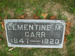
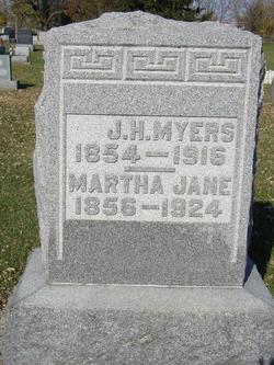
Lementine M Carr Barnett
| Birth | : | 31 Aug 1847 Rush County, Indiana, USA |
| Death | : | 23 Jul 1923 Wabash, Wabash County, Indiana, USA |
| Burial | : | Fairhall Cemetery, Blenheim, Marlborough District, New Zealand |
| Coordinate | : | -41.5294100, 173.8677800 |
| Plot | : | Sec E, lot 145, sp 3 |
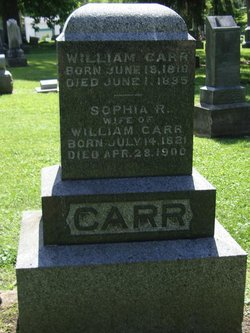
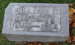
| Description | : | Lementine May Carr Barnett, daughter of William Carr & his wife Sophia Robinson Newbould Carr She was named for her father William's stepmother. (This stepmother was also his aunt. After his mother Ann H "Annie" Hilligoss Carr's death, William Carr's father Isaac Carr married his wife's sister Lementine A "Minty" Hilligoss Carr) Lementine Carr Barnett married William P Barnett, son of James Barnett & his wife Rebecca A Oldaker Barnett 2 Children The Above is NOT FRIENDS OF FALlS CEM BIO THE BELOW is 1920: Residing Noble Twsp, Wabash, Indiana. Widowed; mother of Eula (33). Cause of death: Diabetes |
frequently asked questions (FAQ):
-
Where is Lementine M Carr Barnett's memorial?
Lementine M Carr Barnett's memorial is located at: Fairhall Cemetery, Blenheim, Marlborough District, New Zealand.
-
When did Lementine M Carr Barnett death?
Lementine M Carr Barnett death on 23 Jul 1923 in Wabash, Wabash County, Indiana, USA
-
Where are the coordinates of the Lementine M Carr Barnett's memorial?
Latitude: -41.5294100
Longitude: 173.8677800
Family Members:
Parent

Spouse
Siblings
Children

Flowers:


Nearby Cemetories:
1. Fairhall Cemetery
Blenheim, Marlborough District, New Zealand
Coordinate: -41.5294100, 173.8677800
2. Pioneers Church Cemetery
Renwick, Marlborough District, New Zealand
Coordinate: -41.5091139, 173.8364765
3. Old Renwick Cemetery
Marlborough District, New Zealand
Coordinate: -41.5014030, 173.8909900
4. Upper Wairau Valley Cemetery
Blenheim, Marlborough District, New Zealand
Coordinate: -41.5171130, 173.7974110
5. Omaka Cemetery
Blenheim, Marlborough District, New Zealand
Coordinate: -41.5381800, 173.9401100
6. Rapaura Community Churchyard
Rapaura, Marlborough District, New Zealand
Coordinate: -41.4724800, 173.8995800
7. Rapaura Anglican Cemetery
Rapaura, Marlborough District, New Zealand
Coordinate: -41.4719700, 173.9014700
8. Kaituna Cemetery
Kaituna, Marlborough District, New Zealand
Coordinate: -41.4694650, 173.8036590
9. Maher Family Cemetery
Kaituna, Marlborough District, New Zealand
Coordinate: -41.4682494, 173.7958289
10. Ruakanakana Urupā
Kaituna, Marlborough District, New Zealand
Coordinate: -41.4463616, 173.8779400
11. Māori Island Urupā Otamawahu
Grovetown, Marlborough District, New Zealand
Coordinate: -41.4729310, 173.9778908
12. Wairau Affray Graves
Tuamarina, Marlborough District, New Zealand
Coordinate: -41.4285146, 173.9597007
13. Tuamarina Cemetery
Tuamarina, Marlborough District, New Zealand
Coordinate: -41.4280969, 173.9623665
14. Langley Dale Cemetery
Marlborough District, New Zealand
Coordinate: -41.5076952, 173.7025647
15. Wairau Bar Pilot House Graves
Spring Creek, Marlborough District, New Zealand
Coordinate: -41.4970923, 174.0582651
16. Te Pokohiwi Urupā
Marlborough District, New Zealand
Coordinate: -41.5068950, 174.0612846
17. Taylor Pass Cemetery
Seddon, Marlborough District, New Zealand
Coordinate: -41.6706624, 173.9871644
18. Bartlett's Creek Cemetery
Onamalutu, Marlborough District, New Zealand
Coordinate: -41.5136730, 173.5891660
19. Altimarlock Station
Altimarlock, Marlborough District, New Zealand
Coordinate: -41.7387595, 173.8579141
20. Seddon Cemetery
Seddon, Marlborough District, New Zealand
Coordinate: -41.6831810, 174.0582210
21. Robin Hood Bay Urupā
Marlborough District, New Zealand
Coordinate: -41.3541665, 174.0768701
22. Mahakipawa
Linkwater, Marlborough District, New Zealand
Coordinate: -41.2892290, 173.8474970
23. Wairau Valley Community Churchyard
Wairau Valley, Marlborough District, New Zealand
Coordinate: -41.5604349, 173.5424065
24. Lansdowne Cemetery
Hillersden, Marlborough District, New Zealand
Coordinate: -41.5709846, 173.5434728