
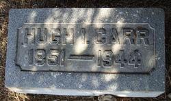
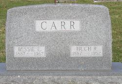
Hugh Isaac Carr
| Birth | : | 17 Sep 1851 Wabash County, Indiana, USA |
| Death | : | 13 Dec 1944 Wabash, Wabash County, Indiana, USA |
| Burial | : | Immaculate Conception Cemetery, Bellevue, Huron County, USA |
| Coordinate | : | 41.2664500, -82.8340630 |
| Plot | : | Sec I, lot 60, sp 5 |
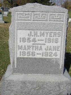
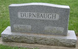
| Description | : | OBITUARY - Plain Dealer, Wabash (IN) The death of Hugh Isaac Carr, 93, occurred Monday morning at 6 o'clock in the home of his daughter, Mrs. Merle Durnbaugh, West Maple street, where he has been residing for the past three years. Mr. Carr, a prominent farmer in this county, was born Sept. 17, 1851, on a farm northwest of LaFontaine where he lived for a few years. He then moved with his parents, William and Sophia Carr, to a farm four miles north of Wabash where he resided until he moved to the home of his daughter. He... Read More |
frequently asked questions (FAQ):
-
Where is Hugh Isaac Carr's memorial?
Hugh Isaac Carr's memorial is located at: Immaculate Conception Cemetery, Bellevue, Huron County, USA.
-
When did Hugh Isaac Carr death?
Hugh Isaac Carr death on 13 Dec 1944 in Wabash, Wabash County, Indiana, USA
-
Where are the coordinates of the Hugh Isaac Carr's memorial?
Latitude: 41.2664500
Longitude: -82.8340630
Family Members:
Parent

Spouse
Siblings
Children
Flowers:


Nearby Cemetories:
1. Immaculate Conception Cemetery
Bellevue, Huron County, USA
Coordinate: 41.2664500, -82.8340630
2. Bellevue Cemetery
Bellevue, Huron County, USA
Coordinate: 41.2658005, -82.8368988
3. Saint Paul United Church of Christ Cemetery
Bellevue, Sandusky County, USA
Coordinate: 41.2703270, -82.8485000
4. Saint Pauls German Lutheran Cemetery
Lyme Township, Huron County, USA
Coordinate: 41.2268600, -82.8172600
5. Strongs Ridge Cemetery
Strongs Ridge, Huron County, USA
Coordinate: 41.2833290, -82.7830582
6. Trinity Episcopal Cemetery
Bellevue, Huron County, USA
Coordinate: 41.2633150, -82.7768610
7. York Free Chapel Cemetery
York, Sandusky County, USA
Coordinate: 41.2803100, -82.8982300
8. Bishop Seybert Cemetery
Flat Rock, Seneca County, USA
Coordinate: 41.2257996, -82.8739014
9. Avery Cemetery
Clyde, Sandusky County, USA
Coordinate: 41.3207290, -82.8499700
10. Gilbert Cemetery
Clyde, Sandusky County, USA
Coordinate: 41.2778015, -82.9186020
11. Underhill Cemetery
Seneca County, USA
Coordinate: 41.2098030, -82.8758530
12. Fireside Cemetery
Seneca County, USA
Coordinate: 41.2270000, -82.9072100
13. Wales Corners Cemetery
Clyde, Sandusky County, USA
Coordinate: 41.3166885, -82.9018860
14. Saint Michaels Cemetery
Frank, Seneca County, USA
Coordinate: 41.1927986, -82.8514023
15. Thompson Center Cemetery
Seneca County, USA
Coordinate: 41.2117004, -82.9024963
16. Hunts Corners Cemetery
Hunts Corners, Huron County, USA
Coordinate: 41.2203800, -82.7539700
17. Deyo Cemetery
Groton Township, Erie County, USA
Coordinate: 41.3428001, -82.8332977
18. Lyme Cemetery
Monroeville, Huron County, USA
Coordinate: 41.2313995, -82.7403030
19. Jones Cemetery
Sherman Township, Huron County, USA
Coordinate: 41.1864400, -82.8063500
20. North Monroeville Cemetery
Monroeville, Huron County, USA
Coordinate: 41.2842200, -82.7248900
21. Ellsworth Cemetery
Clyde, Sandusky County, USA
Coordinate: 41.3293991, -82.9269028
22. Parkhurst Cemetery
Clyde, Sandusky County, USA
Coordinate: 41.3561550, -82.8732740
23. Keegan Farm Cemetery
Clyde, Sandusky County, USA
Coordinate: 41.3659610, -82.8574340
24. Tew Cemetery
Clyde, Sandusky County, USA
Coordinate: 41.3675003, -82.8569031