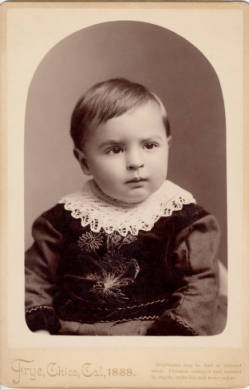
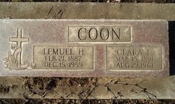
Lemuel Hugh Coon
| Birth | : | 21 Feb 1887 Dayton, Butte County, California, USA |
| Death | : | 15 Dec 1959 Butte County, California, USA |
| Burial | : | Oakland Cemetery, Monticello, Drew County, USA |
| Coordinate | : | 33.6342010, -91.7981033 |
| Plot | : | Sec 26, Lot 1437 |
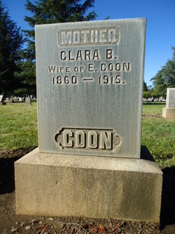
| Description | : | Chico Enterprise-Record, December 1959: "L. H. Coon, Native of Durham, Dies. Death claimed Lemuel Hugh Coon, 72, widely-known Durham rancher, early this morning at Rheingans Hospital in Paradise. He had been stricken with a heart attack on Nov. 12 and his wife and daughter had been at his side since then. "Mr. Coon, the second oldest son of Emmett and Clara Bell Coon, who were early pioneer settlers, had spent his entire life on the place where he was born on Feb. 21, 1887. Following his schooling he engaged in farming and almond growing until three years ago when... Read More |
frequently asked questions (FAQ):
-
Where is Lemuel Hugh Coon's memorial?
Lemuel Hugh Coon's memorial is located at: Oakland Cemetery, Monticello, Drew County, USA.
-
When did Lemuel Hugh Coon death?
Lemuel Hugh Coon death on 15 Dec 1959 in Butte County, California, USA
-
Where are the coordinates of the Lemuel Hugh Coon's memorial?
Latitude: 33.6342010
Longitude: -91.7981033
Family Members:
Parent
Spouse
Siblings
Children
Flowers:
Nearby Cemetories:
1. Oakland Cemetery
Monticello, Drew County, USA
Coordinate: 33.6342010, -91.7981033
2. Kennedy Boulevard Cemetery
Monticello, Drew County, USA
Coordinate: 33.6395700, -91.7756200
3. Manees Cemetery
Drew County, USA
Coordinate: 33.6333100, -91.8243100
4. Rough and Ready Cemetery
Monticello, Drew County, USA
Coordinate: 33.6082993, -91.7891998
5. Gaster Hill Cemetery
Drew County, USA
Coordinate: 33.6591988, -91.8110962
6. Rose Hill Cemetery
Monticello, Drew County, USA
Coordinate: 33.6749992, -91.7827988
7. Rose Hill Cemetery
Meroney, Lincoln County, USA
Coordinate: 33.6753740, -91.7828590
8. Wells Cemetery
Monticello, Drew County, USA
Coordinate: 33.6567980, -91.8438550
9. Priest Cemetery
Monticello, Drew County, USA
Coordinate: 33.6088080, -91.7485850
10. Veasey Cemetery
Drew County, USA
Coordinate: 33.6088220, -91.7485680
11. Brooks Chapel Cemetery
Monticello, Drew County, USA
Coordinate: 33.5959080, -91.8479410
12. Shady Grove AME Cemetery
Cominto, Drew County, USA
Coordinate: 33.6460991, -91.7316971
13. Union Ridge Cemetery #2
Monticello, Drew County, USA
Coordinate: 33.5786500, -91.7823300
14. Union Ridge Cemetery #1
Monticello, Drew County, USA
Coordinate: 33.5766100, -91.7817100
15. Mount Zion African Methodist Episcopal Church Ceme
Monticello, Drew County, USA
Coordinate: 33.6892960, -91.7367250
16. Zion Hill
Monticello, Drew County, USA
Coordinate: 33.6383080, -91.7027281
17. Torian Cemetery
Drew County, USA
Coordinate: 33.6758003, -91.8927994
18. Old Saline Church Cemetery
Wilmar, Drew County, USA
Coordinate: 33.6197014, -91.9083023
19. Andrews Chapel Cemetery
Barkada, Drew County, USA
Coordinate: 33.6716995, -91.9021988
20. Campground Cemetery
Monticello, Drew County, USA
Coordinate: 33.7292890, -91.8218650
21. Bethel Cemetery
Drew County, USA
Coordinate: 33.6755981, -91.9119034
22. Baker Cemetery
Drew County, USA
Coordinate: 33.5318985, -91.7686005
23. Green Hill Cemetery
Green Hill, Drew County, USA
Coordinate: 33.5647011, -91.8972015
24. Enon Cemetery
Enon, Drew County, USA
Coordinate: 33.5882988, -91.6789017

