
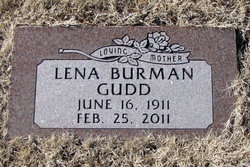

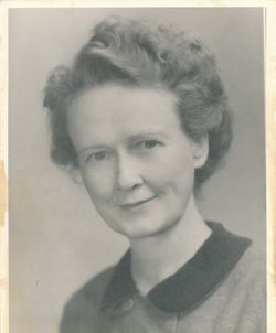
Lena Burman Gudd
| Birth | : | 16 Jun 1911 Shawnee County, Kansas, USA |
| Death | : | 24 Feb 2011 San Francisco County, California, USA |
| Burial | : | Foster Cemetery, Topeka, Shawnee County, USA |
| Coordinate | : | 38.9942017, -95.7061005 |
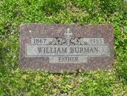
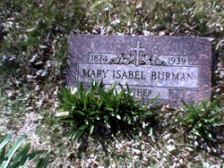
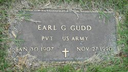
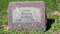
| Description | : | Lena Burman Gudd passed away peacefully on February 24, 2011, just a few months shy of her 100th birthday. She was with her daughter, Carol and son-in law, Barry at home in San Francisco. She had been under care of Hospice by the Bay at home for about ten days. Lena Gudd was born in Kansas in 1911 and was the last surviving of 12 children born to Mary and William Burman. She moved to Arizona with her second husband, Earl Gudd, in 1952 and fell in love with the desert, especially the weather. She is a graduate of Washburn High... Read More |
frequently asked questions (FAQ):
-
Where is Lena Burman Gudd's memorial?
Lena Burman Gudd's memorial is located at: Foster Cemetery, Topeka, Shawnee County, USA.
-
When did Lena Burman Gudd death?
Lena Burman Gudd death on 24 Feb 2011 in San Francisco County, California, USA
-
Where are the coordinates of the Lena Burman Gudd's memorial?
Latitude: 38.9942017
Longitude: -95.7061005
Family Members:
Parent
Spouse
Siblings

Flowers:


Nearby Cemetories:
1. Foster Cemetery
Topeka, Shawnee County, USA
Coordinate: 38.9942017, -95.7061005
2. Ritchie Cemetery
Topeka, Shawnee County, USA
Coordinate: 39.0228010, -95.7027530
3. Carnegie Hall
Topeka, Shawnee County, USA
Coordinate: 39.0350600, -95.6999100
4. Elevation Cemetery
Shawnee County, USA
Coordinate: 38.9832993, -95.7613983
5. Saint Davids Episcopal Church Columbarium
Topeka, Shawnee County, USA
Coordinate: 39.0369860, -95.7259480
6. Westminster Presbyterian Church Memorial Garden
Topeka, Shawnee County, USA
Coordinate: 39.0430400, -95.7021700
7. Mount Hope Cemetery
Topeka, Shawnee County, USA
Coordinate: 39.0367393, -95.7386703
8. Abram Burnett Burial Site
Topeka, Shawnee County, USA
Coordinate: 39.0102997, -95.7685776
9. Grace Episcopal Cathedral Sanctuary
Topeka, Shawnee County, USA
Coordinate: 39.0506925, -95.6839273
10. Grace Episcopal Cathedral Columbarium
Topeka, Shawnee County, USA
Coordinate: 39.0511284, -95.6843719
11. Topeka Cemetery
Topeka, Shawnee County, USA
Coordinate: 39.0388985, -95.6528015
12. Mission Center Cemetery
Topeka, Shawnee County, USA
Coordinate: 39.0145493, -95.7819290
13. Lynn Creek Cemetery
Berryton, Shawnee County, USA
Coordinate: 38.9575005, -95.6408005
14. Mount Auburn Cemetery
Topeka, Shawnee County, USA
Coordinate: 39.0393982, -95.6500015
15. Mount Calvary Cemetery
Topeka, Shawnee County, USA
Coordinate: 39.0532990, -95.7360992
16. Memorial Park Cemetery
Topeka, Shawnee County, USA
Coordinate: 39.0619011, -95.7221985
17. Topeka State Hospital Cemetery
Topeka, Shawnee County, USA
Coordinate: 39.0671005, -95.7080994
18. Security Benefit Association Cemetery
Topeka, Shawnee County, USA
Coordinate: 39.0630989, -95.7606583
19. Simerwell Cemetery
Shawnee County, USA
Coordinate: 38.9132004, -95.7483597
20. Curtis Family Cemetery
North Topeka, Shawnee County, USA
Coordinate: 39.0792870, -95.6702270
21. Bethel Cemetery
Topeka, Shawnee County, USA
Coordinate: 39.0085983, -95.5864029
22. Bauer Cemetery
Topeka, Shawnee County, USA
Coordinate: 38.9864006, -95.5764008
23. West Lawn Memorial Gardens
Topeka, Shawnee County, USA
Coordinate: 39.0518112, -95.8167419
24. Emmanuel Cemetery
Watson, Shawnee County, USA
Coordinate: 38.9719009, -95.5744019