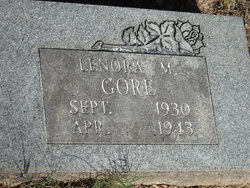
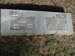
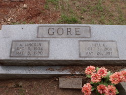
Lenora Mae Gore
| Birth | : | 13 Sep 1930 Arkansas, USA |
| Death | : | 4 Apr 1943 Sevier County, Arkansas, USA |
| Burial | : | Cobden Cemetery, Cobden, Renfrew County, Canada |
| Coordinate | : | 45.6171200, -76.8671200 |
| Description | : | Child 13 Burns to death in House fire Lenora Mae Gore 13 year old daughter of Mr. & Mrs.Lincoln Gore was burned to death when fire destroyed the house of N.P. Clements 9 miles south of DeQueen Ark.at 3:30 am Sunday morning. Cause of the fire was not determined. Clements said when he awakened,Flames were enveloping the four room house and that he and his family barely had time to escape according to Clements the Gore child ran out of the burning house and reentered through A rear door to get her clothing,her body was found in the kitchen of the house,neighbors kept the flames from... Read More |
frequently asked questions (FAQ):
-
Where is Lenora Mae Gore's memorial?
Lenora Mae Gore's memorial is located at: Cobden Cemetery, Cobden, Renfrew County, Canada.
-
When did Lenora Mae Gore death?
Lenora Mae Gore death on 4 Apr 1943 in Sevier County, Arkansas, USA
-
Where are the coordinates of the Lenora Mae Gore's memorial?
Latitude: 45.6171200
Longitude: -76.8671200
Family Members:
Parent
Siblings
Flowers:
Nearby Cemetories:
1. Cobden Cemetery
Cobden, Renfrew County, Canada
Coordinate: 45.6171200, -76.8671200
2. Pioneer Cemetery
Osceola, Renfrew County, Canada
Coordinate: 45.6231291, -76.9430902
3. Saint Pius V Cemetery
Osceola, Renfrew County, Canada
Coordinate: 45.6257000, -76.9445000
4. Beachburg Mennonite Cemetery
Cobden, Renfrew County, Canada
Coordinate: 45.6728430, -76.8527980
5. Beachburg Mennonite Cemetery
Beachburg, Renfrew County, Canada
Coordinate: 45.6751052, -76.8551953
6. Haley Cemetery
Haley Station, Renfrew County, Canada
Coordinate: 45.5722300, -76.7880700
7. Howard Cemetery
Foresters Falls, Renfrew County, Canada
Coordinate: 45.6787224, -76.7817764
8. Saint Andrew's Presbyterian Cemetery
Kerr Line, Renfrew County, Canada
Coordinate: 45.6479200, -76.7433600
9. Rosebank Cemetery
Rosebank, Renfrew County, Canada
Coordinate: 45.5251000, -76.7829110
10. Beachburg Union Cemetery
Beachburg, Renfrew County, Canada
Coordinate: 45.7300987, -76.8577194
11. St. Augustine Anglican Cemetery
Beachburg, Renfrew County, Canada
Coordinate: 45.7306000, -76.8597300
12. St. Augustines Anglican
Westmeath, Renfrew County, Canada
Coordinate: 45.7306000, -76.8597000
13. Saint Michael Roman Catholic Cemetery
Bromley, Renfrew County, Canada
Coordinate: 45.5166367, -76.9439485
14. Douglas Public Cemetery
Douglas, Renfrew County, Canada
Coordinate: 45.5119600, -76.9439500
15. Micksburg United Cemetery
Micksburg, Renfrew County, Canada
Coordinate: 45.6615600, -77.0353000
16. Saint Patricks Anglican Cemetery
Cobden, Renfrew County, Canada
Coordinate: 45.7103750, -77.0024870
17. Stafford United Church Cemetery
Cobden, Renfrew County, Canada
Coordinate: 45.7120380, -77.0029160
18. Micksburg Presbyterian Cemetery
Micksburg, Renfrew County, Canada
Coordinate: 45.6705200, -77.0462600
19. McDonald Burying Ground
Westmeath, Renfrew County, Canada
Coordinate: 45.7178231, -77.0010204
20. St. George Anglican Church Cemetery
Portage-du-Fort, Outaouais Region, Canada
Coordinate: 45.5934170, -76.6678210
21. Saint Stephen Anglican Cemetery
Micksburg, Renfrew County, Canada
Coordinate: 45.6759620, -77.0546720
22. Litchfield United Cemetery
Outaouais Region, Canada
Coordinate: 45.6309030, -76.6564860
23. Protestant Cemetery of Portage du Fort
Portage-du-Fort, Outaouais Region, Canada
Coordinate: 45.5926410, -76.6584030
24. St. James Roman Catholic Cemetery
Portage-du-Fort, Outaouais Region, Canada
Coordinate: 45.5929000, -76.6582800

