
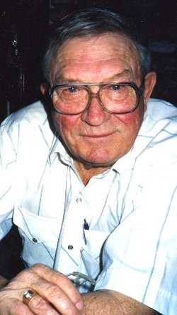


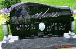
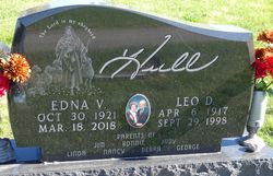
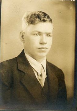
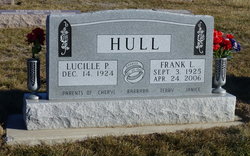
Leo Dale Hull
| Birth | : | 6 Apr 1917 Monona County, Iowa, USA |
| Death | : | 29 Sep 1998 Omaha, Douglas County, Nebraska, USA |
| Burial | : | Misterton Cemetery, Misterton, South Somerset District, England |
| Coordinate | : | 50.8684960, -2.7687390 |
| Description | : | MOORHEAD- Leo Dale Hull, 81, of Moorhead died Sept. 29 at Immanuel Medical Center in Omaha. He was born in Willow Township in Monona County, attended Willow country school and graduated from Dunlap High School in 1933. He farmed in Willow Township and moved to Moorhead in 1985. He was a member of the Moorhead Christian Church, served on the church board and as a deacon. He served on the Willow Township, Moorhead Community and East Monona school boards, the Dunlap Savings Bank Board and Moorhead and Soldier Co-op boards and was a... Read More |
frequently asked questions (FAQ):
-
Where is Leo Dale Hull's memorial?
Leo Dale Hull's memorial is located at: Misterton Cemetery, Misterton, South Somerset District, England.
-
When did Leo Dale Hull death?
Leo Dale Hull death on 29 Sep 1998 in Omaha, Douglas County, Nebraska, USA
-
Where are the coordinates of the Leo Dale Hull's memorial?
Latitude: 50.8684960
Longitude: -2.7687390
Family Members:
Parent
Spouse
Siblings

Flowers:


Nearby Cemetories:
1. Misterton Cemetery
Misterton, South Somerset District, England
Coordinate: 50.8684960, -2.7687390
2. Saint Leonards Churchyard
Misterton, South Somerset District, England
Coordinate: 50.8698905, -2.7795252
3. St Martin's Churchyard
North Perrott, South Somerset District, England
Coordinate: 50.8828270, -2.7518080
4. Townsend Cemetery
Crewkerne, South Somerset District, England
Coordinate: 50.8823800, -2.7952100
5. Saint Mary's Church
Mosterton, West Dorset District, England
Coordinate: 50.8466690, -2.7723670
6. St Bartholomew Churchyard
Crewkerne, South Somerset District, England
Coordinate: 50.8851640, -2.7981790
7. St. Michael and All Angels Churchyard
Haselbury Plucknett, South Somerset District, England
Coordinate: 50.8954140, -2.7531080
8. Saint John Churchyard
Seaborough, West Dorset District, England
Coordinate: 50.8502200, -2.8112800
9. St James Cemetery
Chedington, West Dorset District, England
Coordinate: 50.8473070, -2.7275580
10. All Saints Churchyard
Merriott, South Somerset District, England
Coordinate: 50.9123410, -2.7941670
11. St. Margaret's Churchyard
Middle Chinnock, South Somerset District, England
Coordinate: 50.9151370, -2.7522120
12. St John the Baptist Churchyard
Broadwindsor, West Dorset District, England
Coordinate: 50.8205790, -2.7996230
13. St George Churchyard
Hinton St George, South Somerset District, England
Coordinate: 50.9106520, -2.8285630
14. St Andrew Churchyard
Burstock, West Dorset District, England
Coordinate: 50.8228330, -2.8216970
15. St Marys Churchyard
Hardington Mandeville, South Somerset District, England
Coordinate: 50.9046300, -2.6954050
16. St. Mary's Churchyard
East Chinnock, South Somerset District, England
Coordinate: 50.9164240, -2.7145142
17. Holy Trinity Churchyard
Beaminster, West Dorset District, England
Coordinate: 50.8125230, -2.7376500
18. St. Mary's Churchyard
Corscombe, West Dorset District, England
Coordinate: 50.8413300, -2.6797630
19. St Mary of the Annunciation Churchyard
Beaminster, West Dorset District, England
Coordinate: 50.8085130, -2.7409170
20. St. Peter and St. Paul's Churchyard
Chiselborough, South Somerset District, England
Coordinate: 50.9308340, -2.7589220
21. All Saints Churchyard
Lopen, South Somerset District, England
Coordinate: 50.9270850, -2.8164620
22. Saint Nicholas Churchyard
Dinnington, South Somerset District, England
Coordinate: 50.9111810, -2.8505240
23. Chillington St James Churchyard and Cemetery
Chillington, South Somerset District, England
Coordinate: 50.8959300, -2.8689200
24. Parnham House
Beaminster, West Dorset District, England
Coordinate: 50.7995080, -2.7418580