
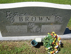
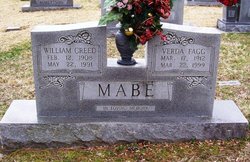
Leola Azile Mabe Brown
| Birth | : | 14 Oct 1916 Stokes County, North Carolina, USA |
| Death | : | 7 Jun 1999 Winston-Salem, Forsyth County, North Carolina, USA |
| Burial | : | Saint Michael and All Angels Churchyard, Felton, Northumberland Unitary Authority, England |
| Coordinate | : | 52.8203010, -2.9792430 |
frequently asked questions (FAQ):
-
Where is Leola Azile Mabe Brown's memorial?
Leola Azile Mabe Brown's memorial is located at: Saint Michael and All Angels Churchyard, Felton, Northumberland Unitary Authority, England.
-
When did Leola Azile Mabe Brown death?
Leola Azile Mabe Brown death on 7 Jun 1999 in Winston-Salem, Forsyth County, North Carolina, USA
-
Where are the coordinates of the Leola Azile Mabe Brown's memorial?
Latitude: 52.8203010
Longitude: -2.9792430
Family Members:
Parent

Spouse

Siblings
Children

Flowers:


Nearby Cemetories:
1. Saint Michael and All Angels Churchyard
Felton, Northumberland Unitary Authority, England
Coordinate: 52.8203010, -2.9792430
2. St Mary the Virgin Parish Church
Hordley, Shropshire Unitary Authority, England
Coordinate: 52.8713670, -2.9208050
3. All Saints Churchyard
Baschurch, Shropshire Unitary Authority, England
Coordinate: 52.7913710, -2.8586210
4. St. Barnabas Churchyard
Hengoed, Shropshire Unitary Authority, England
Coordinate: 52.8883855, -3.0562708
5. Preeshenlle United Reformed Churchyard
Gobowen, Shropshire Unitary Authority, England
Coordinate: 52.8991040, -3.0356200
6. St. Simon and St. Jude Churchyard
Cockshutt, Shropshire Unitary Authority, England
Coordinate: 52.8577297, -2.8412706
7. Alberbury Priory
Alberbury, Shropshire Unitary Authority, England
Coordinate: 52.7311000, -2.9267000
8. St. Michael and All Angels Churchyard
Alberbury, Shropshire Unitary Authority, England
Coordinate: 52.7236380, -2.9509280
9. Saint Mary's Churchyard
Ellesmere, Shropshire Unitary Authority, England
Coordinate: 52.9075740, -2.8894550
10. Ellesmere Cemetery
Ellesmere, Shropshire Unitary Authority, England
Coordinate: 52.9111900, -2.8906500
11. St. Matthew's Churchyard
Ellesmere Rural, Shropshire Unitary Authority, England
Coordinate: 52.9240135, -2.9467180
12. St Peter and St Paul Churchyard
Fitz, Shropshire Unitary Authority, England
Coordinate: 52.7553657, -2.8182247
13. All Saints Churchyard
Alberbury, Shropshire Unitary Authority, England
Coordinate: 52.7062510, -3.0333570
14. St Mary's Churchyard Dudleston
Ellesmere, Shropshire Unitary Authority, England
Coordinate: 52.9392780, -2.9745280
15. St. Michael Churchyard
Ford, Shropshire Unitary Authority, England
Coordinate: 52.7184248, -2.8715080
16. St. Michael’s Churchyard
Cardeston, Shropshire Unitary Authority, England
Coordinate: 52.7050600, -2.8960090
17. Bomere Heath Methodist Church Burial Ground
Bomere Heath, Shropshire Unitary Authority, England
Coordinate: 52.7734260, -2.7833720
18. Bicton Cemetery
Bicton, Shropshire Unitary Authority, England
Coordinate: 52.7284870, -2.8183830
19. St John the Baptist Churchyard
Albrighton, Shropshire Unitary Authority, England
Coordinate: 52.7572400, -2.7462600
20. All Saints Church
Clive, Shropshire Unitary Authority, England
Coordinate: 52.8116250, -2.7212930
21. St Thomas Churchyard
Great Hanwood, Shropshire Unitary Authority, England
Coordinate: 52.6812150, -2.8242660
22. St. Mary Magdalene Church
Hadnall, Shropshire Unitary Authority, England
Coordinate: 52.7759670, -2.7100180
23. St. Mary's Churchyard
Edstaston, Shropshire Unitary Authority, England
Coordinate: 52.8830727, -2.7182040
24. Coton Primitive Methodist Chapel
Cotonwood, Shropshire Unitary Authority, England
Coordinate: 52.9191890, -2.6926830