
| Memorials | : | 0 |
| Location | : | Cotonwood, Shropshire Unitary Authority, England |
| Coordinate | : | 52.9191890, -2.6926830 |
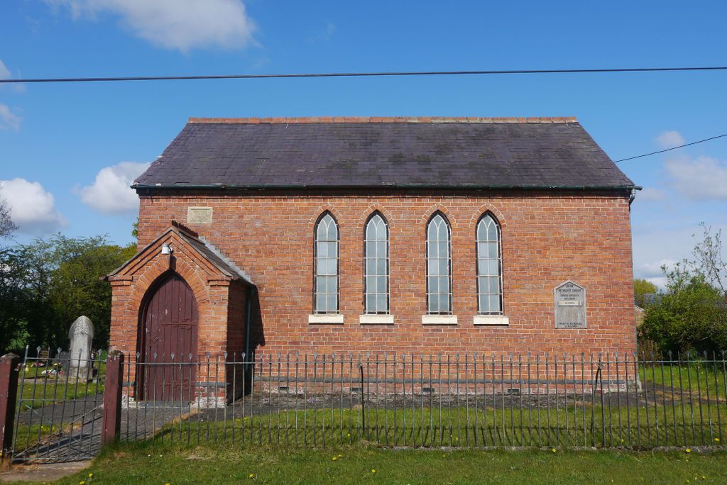
| Description | : | There were Primitive Methodist meetings in Cotonwood for several decades before a chapel was built. In 1851 they were meeting in a dwelling house and in the Religious Census taken in March of that year they had 33 worshippers at their Sunday evening service. This little chapel was built on land bought on 23rd June 1888 for £25 from G. Batho of Heath Lane, near Whitchurch. This was followed on the 4th July by a stone laying ceremony. The chapel cost just over £70 to build. By 1904 the chapel was free of debt. The chapel was registered for the... Read More |
frequently asked questions (FAQ):
-
Where is Coton Primitive Methodist Chapel?
Coton Primitive Methodist Chapel is located at Wem Rural Cotonwood, Shropshire Unitary Authority ,Shropshire , SY13 3LTEngland.
-
Coton Primitive Methodist Chapel cemetery's updated grave count on graveviews.com?
0 memorials
-
Where are the coordinates of the Coton Primitive Methodist Chapel?
Latitude: 52.9191890
Longitude: -2.6926830


Nearby Cemetories:
1. St. Mary's Churchyard
Edstaston, Shropshire Unitary Authority, England
Coordinate: 52.8830727, -2.7182040
2. Christ Church
Ash Magna, Shropshire Unitary Authority, England
Coordinate: 52.9575430, -2.6287860
3. St John The Baptist Churchyard
Ightfield, Shropshire Unitary Authority, England
Coordinate: 52.9438900, -2.6081000
4. Calverhall Holy Trinity
Calverhall, Shropshire Unitary Authority, England
Coordinate: 52.9311270, -2.5917490
5. St Michael Churchyard
Marbury-cum-Quoisley, Cheshire East Unitary Authority, England
Coordinate: 53.0062980, -2.6564160
6. Old St. Chad's Church and Cemetery
Tushingham, Cheshire West and Chester Unitary Authority, England
Coordinate: 53.0115193, -2.7061829
7. St Luke's Churchyard
Hodnet, Shropshire Unitary Authority, England
Coordinate: 52.8536780, -2.5772160
8. St. Simon and St. Jude Churchyard
Cockshutt, Shropshire Unitary Authority, England
Coordinate: 52.8577297, -2.8412706
9. All Saints Church
Clive, Shropshire Unitary Authority, England
Coordinate: 52.8116250, -2.7212930
10. St. Oswald's Churchyard
Malpas, Cheshire West and Chester Unitary Authority, England
Coordinate: 53.0194240, -2.7669350
11. United Reformed Church Burial Ground
Malpas, Cheshire West and Chester Unitary Authority, England
Coordinate: 53.0198355, -2.7673954
12. Malpas Cemetery
Malpas, Cheshire West and Chester Unitary Authority, England
Coordinate: 53.0262800, -2.7633600
13. St Peter Churchyard
Adderley, Shropshire Unitary Authority, England
Coordinate: 52.9517090, -2.5061580
14. St. Wenefredes Churchyard
Bickley, Cheshire West and Chester Unitary Authority, England
Coordinate: 53.0365490, -2.6924400
15. St Margaret Churchyard
Wrenbury-cum-Frith, Cheshire East Unitary Authority, England
Coordinate: 53.0256700, -2.6073340
16. Saint Mary's Churchyard
Ellesmere, Shropshire Unitary Authority, England
Coordinate: 52.9075740, -2.8894550
17. Ellesmere Cemetery
Ellesmere, Shropshire Unitary Authority, England
Coordinate: 52.9111900, -2.8906500
18. St. John's Churchyard
Threapwood, Cheshire West and Chester Unitary Authority, England
Coordinate: 53.0023350, -2.8359540
19. Bateman Memorial Chapel
Chorley, Cheshire East Unitary Authority, England
Coordinate: 53.0549000, -2.6368300
20. St Michael Churchyard
Baddiley, Cheshire East Unitary Authority, England
Coordinate: 53.0488780, -2.5905830
21. St. Mary Magdalene Church
Hadnall, Shropshire Unitary Authority, England
Coordinate: 52.7759670, -2.7100180
22. St Mary the Virgin Parish Church
Hordley, Shropshire Unitary Authority, England
Coordinate: 52.8713670, -2.9208050
23. St Michael & All Angels
Childs Ercall, Shropshire Unitary Authority, England
Coordinate: 52.8222524, -2.4975524
24. St. Matthew's Churchyard
Ellesmere Rural, Shropshire Unitary Authority, England
Coordinate: 52.9240135, -2.9467180