
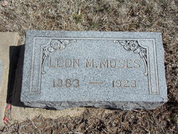
Leon M. Moses
| Birth | : | 8 Jan 1882 Newbern, Pulaski County, Virginia, USA |
| Death | : | 12 Nov 1923 Longford, Clay County, Kansas, USA |
| Burial | : | Wesleyan Cemetery, Oak Hill, Clay County, USA |
| Coordinate | : | 39.2268982, -97.2572021 |
| Description | : | Longford Journal, Thursday, November 22, 1923, page 1: Leon M. Moses was born at Newbern, Virginia, January 8, 1882, and passed away at his home near Longford, Kansas, November 12, 1923, age 40 years, 10 months and 2 days. He was taken sick with the flu last February, from which he was unable to recover his strength. Other complications began and his trouble was pronounced Intestinal Tuberculosis and for some time before his death he felt that he could not recover. He moved from Iowa to Lane county, Kansas, and located near Dighton, where he spent the years of his... Read More |
frequently asked questions (FAQ):
-
Where is Leon M. Moses's memorial?
Leon M. Moses's memorial is located at: Wesleyan Cemetery, Oak Hill, Clay County, USA.
-
When did Leon M. Moses death?
Leon M. Moses death on 12 Nov 1923 in Longford, Clay County, Kansas, USA
-
Where are the coordinates of the Leon M. Moses's memorial?
Latitude: 39.2268982
Longitude: -97.2572021
Family Members:
Parent

Spouse
Siblings
Children
Flowers:


Nearby Cemetories:
1. Wesleyan Cemetery
Oak Hill, Clay County, USA
Coordinate: 39.2268982, -97.2572021
2. Pleasant Valley Cemetery
Oak Hill, Clay County, USA
Coordinate: 39.2468987, -97.2889023
3. Rose Meron Cemetery
Oak Hill, Clay County, USA
Coordinate: 39.2194700, -97.3338900
4. Pleasant Ridge Cemetery
Clay County, USA
Coordinate: 39.2789001, -97.1841965
5. Athelstane Cemetery
Athelstane Township, Clay County, USA
Coordinate: 39.1768990, -97.1753006
6. Table Mound Cemetery
Idana, Clay County, USA
Coordinate: 39.3141300, -97.2792300
7. Hebron Cemetery
Clay County, USA
Coordinate: 39.3213800, -97.2601400
8. Zion Lutheran Cemetery
Clay County, USA
Coordinate: 39.2928009, -97.1557999
9. Mizpah Cemetery
Clay County, USA
Coordinate: 39.2057800, -97.1238500
10. Keystone Cemetery
Manchester, Dickinson County, USA
Coordinate: 39.1185989, -97.2917023
11. Swartwood Cemetery
Longford, Clay County, USA
Coordinate: 39.1323200, -97.3431500
12. Shields Cemetery
Clay County, USA
Coordinate: 39.3208008, -97.3507996
13. Uniondale Cemetery
Wakefield, Clay County, USA
Coordinate: 39.2382800, -97.0918400
14. Idana Cemetery
Idana, Clay County, USA
Coordinate: 39.3574500, -97.2693300
15. Republican City Cemetery
Clay Center, Clay County, USA
Coordinate: 39.3431015, -97.1628036
16. Greenridge Cemetery
Dickinson County, USA
Coordinate: 39.1199989, -97.1433029
17. Mount Liberty Church Cemetery
Ottawa County, USA
Coordinate: 39.2489400, -97.4356200
18. Saint John's Episcopal Cemetery
Clay County, USA
Coordinate: 39.2193985, -97.0744019
19. Henry Cemetery
Buckeye, Dickinson County, USA
Coordinate: 39.0828018, -97.1857986
20. Milo Chapman Gravesite
Broughton, Clay County, USA
Coordinate: 39.2888500, -97.0724400
21. Gilbert Cemetery
Clay County, USA
Coordinate: 39.2853012, -97.0625000
22. Wilson Cemetery
Clay County, USA
Coordinate: 39.3800011, -97.1896973
23. Vine Creek Cemetery
Ottawa County, USA
Coordinate: 39.1194000, -97.4180984
24. White Cloud Cemetery
Manchester, Dickinson County, USA
Coordinate: 39.0744019, -97.3525009