
| Birth | : | 24 Sep 1897 Saint Joseph, Cloud County, Kansas, USA |
| Death | : | 20 Oct 1971 Concordia, Cloud County, Kansas, USA |
| Burial | : | Mount Calvary Cemetery, Clyde, Cloud County, USA |
| Coordinate | : | 39.5917015, -97.4143982 |
| Plot | : | Site A/18 |
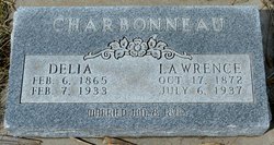
| Description | : | The Kansan; Concordia, Cloud County, Kansas 21 Oct 1971 Mrs. Eddie Chaput of Clyde died at St. Joseph hospital on Wednesday, Oct 20 after a short illness. She had suffered a heart attack on Tuesday. She was 74. Mrs. Chaput, the former Leona Charbonneau was born at St Joseph, Kansas, on September 24, 1897, the daughter of Mr. and Mrs. Lawrence Charbonneau. She was member of the Catholic Church and the catholic daughter of America at Clyde. She was married to Eddie Chaput on September 23, 1913 at St Joseph. They moved to Clyde from the farm in 1946. Survivors are her... Read More |
frequently asked questions (FAQ):
-
Where is Leona Marie Charboneau Chaput's memorial?
Leona Marie Charboneau Chaput's memorial is located at: Mount Calvary Cemetery, Clyde, Cloud County, USA.
-
When did Leona Marie Charboneau Chaput death?
Leona Marie Charboneau Chaput death on 20 Oct 1971 in Concordia, Cloud County, Kansas, USA
-
Where are the coordinates of the Leona Marie Charboneau Chaput's memorial?
Latitude: 39.5917015
Longitude: -97.4143982
Family Members:
Parent

Spouse

Siblings
Children

Flowers:


Nearby Cemetories:
1. Mount Calvary Cemetery
Clyde, Cloud County, USA
Coordinate: 39.5917015, -97.4143982
2. Mount Hope Cemetery
Clyde, Cloud County, USA
Coordinate: 39.5969009, -97.4116974
3. Cedar Grove Cemetery
Clyde, Cloud County, USA
Coordinate: 39.5494003, -97.4056015
4. Pleasant View Cemetery
Ames, Cloud County, USA
Coordinate: 39.5346985, -97.4431000
5. Walnut Grove Cemetery
Cloud County, USA
Coordinate: 39.5699997, -97.4993973
6. Saint Joseph Cemetery
Saint Joseph, Cloud County, USA
Coordinate: 39.5074941, -97.4022328
7. Agenda Cemetery
Agenda, Republic County, USA
Coordinate: 39.6761017, -97.4336014
8. Green Mound Cemetery
Rice, Cloud County, USA
Coordinate: 39.5248450, -97.5081630
9. Hollis Cemetery
Cloud County, USA
Coordinate: 39.6383018, -97.5361023
10. Beck Family Cemetery
Agenda, Republic County, USA
Coordinate: 39.6818000, -97.4863000
11. Rice Cemetery
Rice, Cloud County, USA
Coordinate: 39.5614014, -97.5552979
12. Nelson Cemetery
Rice, Cloud County, USA
Coordinate: 39.5257988, -97.5410995
13. Riverdale Cemetery
Clay County, USA
Coordinate: 39.5106010, -97.2930984
14. Saint Peters Cemetery
Aurora, Cloud County, USA
Coordinate: 39.4763985, -97.5180969
15. Princeville Cemetery
Aurora, Cloud County, USA
Coordinate: 39.4672012, -97.5010986
16. Iwacura Cemetery
Morganville, Clay County, USA
Coordinate: 39.4550000, -97.3510000
17. Union Cemetery
Wayne, Republic County, USA
Coordinate: 39.6977997, -97.5457993
18. Willoughby Cemetery
Agenda, Republic County, USA
Coordinate: 39.7402992, -97.4244003
19. French Presbyterian Church Cemetery
Cloud County, USA
Coordinate: 39.4395200, -97.4148290
20. Gotland Cemetery
Sibley Township, Cloud County, USA
Coordinate: 39.6091995, -97.6125031
21. Sherman Cemetery
Morganville, Clay County, USA
Coordinate: 39.5316300, -97.2243700
22. Zion Cemetery
Agenda, Republic County, USA
Coordinate: 39.6749992, -97.5939026
23. Rose Hill Cemetery
Wayne, Republic County, USA
Coordinate: 39.7111015, -97.5661011
24. Minersville Cemetery
Talmo, Republic County, USA
Coordinate: 39.6568330, -97.6229250