
| Birth | : | 19 Nov 1879 Ameide, Zederik Municipality, Zuid-Holland, Netherlands |
| Death | : | 8 Dec 1947 Townsend, Broadwater County, Montana, USA |
| Burial | : | Purewa Cemetery, Meadowbank, Auckland Council, New Zealand |
| Coordinate | : | -36.8674300, 174.8297900 |
| Plot | : | Family Plot 265 |
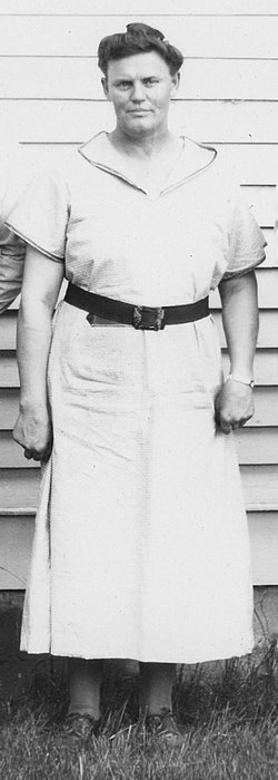
| Description | : | Len (Leendert in Dutch) Verwolf, 68, a native of Holland and a resident of Manhattan for the last 50 years, died Monday afternoon at the hospital in Townsend. He had been ill for the last six weeks. Born in Ameide, Holland, November 19, 1879, he came to the United States with his parents when he was 10 years old, and came to Manhattan when he was 18 years old. He has made his home there since that time, and for a while was engaged in farming and later ran a butcher shop. At the time of his death... Read More |
frequently asked questions (FAQ):
-
Where is Leonard “Leendert” Verwolf's memorial?
Leonard “Leendert” Verwolf's memorial is located at: Purewa Cemetery, Meadowbank, Auckland Council, New Zealand.
-
When did Leonard “Leendert” Verwolf death?
Leonard “Leendert” Verwolf death on 8 Dec 1947 in Townsend, Broadwater County, Montana, USA
-
Where are the coordinates of the Leonard “Leendert” Verwolf's memorial?
Latitude: -36.8674300
Longitude: 174.8297900
Family Members:
Parent
Spouse

Siblings
Children

Flowers:


Nearby Cemetories:
1. Purewa Cemetery
Meadowbank, Auckland Council, New Zealand
Coordinate: -36.8674300, 174.8297900
2. Ōrākei (Rautara St) Urupā
Orakei, Auckland Council, New Zealand
Coordinate: -36.8610770, 174.8188960
3. St. John’s College Graveyard
Saint Johns, Auckland Council, New Zealand
Coordinate: -36.8738169, 174.8416826
4. St. Thomas Churchyard
Tamaki, Auckland Council, New Zealand
Coordinate: -36.8675590, 174.8460560
5. Savage Memorial
Auckland, Auckland Council, New Zealand
Coordinate: -36.8462500, 174.8259300
6. Point England Presbyterian Cemetery
Point England, Auckland Council, New Zealand
Coordinate: -36.8823420, 174.8601550
7. St. Stephen's Churchyard
Auckland, Auckland Council, New Zealand
Coordinate: -36.8504860, 174.7899970
8. St Mark's Anglican Church Cemetery
Remuera, Auckland Council, New Zealand
Coordinate: -36.8729300, 174.7801600
9. St. Patrick's Roman Catholic Church Cemetery
Panmure, Auckland Council, New Zealand
Coordinate: -36.9029680, 174.8564960
10. St Matthias Churchyard
Panmure, Auckland Council, New Zealand
Coordinate: -36.9053300, 174.8577200
11. Royal New Zealand Navy Memorial
Devonport, Auckland Council, New Zealand
Coordinate: -36.8305900, 174.7898900
12. Mount Victoria Cemetery
Devonport, Auckland Council, New Zealand
Coordinate: -36.8252490, 174.7978140
13. Mount Eden Stockade Cemetery
Mount Eden, Auckland Council, New Zealand
Coordinate: -36.8678370, 174.7666430
14. Symonds Street Cemetery
Auckland, Auckland Council, New Zealand
Coordinate: -36.8582828, 174.7636628
15. Saint Andrew's Churchyard
Epsom, Auckland Council, New Zealand
Coordinate: -36.8937200, 174.7654100
16. Pakuranga Methodist Cemetery
Pakuranga, Auckland Council, New Zealand
Coordinate: -36.9054000, 174.8914900
17. Our Lady of the Assumption Catholic Church
Ōnehunga, Auckland Council, New Zealand
Coordinate: -36.9223690, 174.7884530
18. Onehunga Catholic Cemetery
Ōnehunga, Auckland Council, New Zealand
Coordinate: -36.9224360, 174.7884560
19. St. Peter's Anglican Cemetery
Ōnehunga, Auckland Council, New Zealand
Coordinate: -36.9227113, 174.7847550
20. Waikaraka Cemetery
Ōnehunga, Auckland Council, New Zealand
Coordinate: -36.9297140, 174.7967170
21. O'Neill's Point Cemetery
Belmont, Auckland Council, New Zealand
Coordinate: -36.8103002, 174.7812784
22. Howick Historical Village
Pakuranga, Auckland Council, New Zealand
Coordinate: -36.9067680, 174.9027080
23. Holy Trinity Memorial Park
Ōtāhūhū, Auckland Council, New Zealand
Coordinate: -36.9374510, 174.8448580
24. Otahuhu Public Cemetery
Ōtāhūhū, Auckland Council, New Zealand
Coordinate: -36.9377500, 174.8432390