

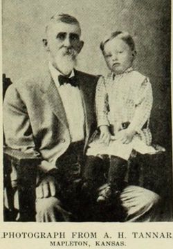
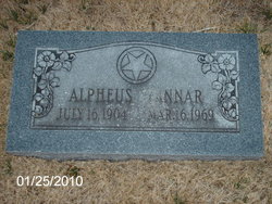
Leonard W Tannar
| Birth | : | 17 May 1875 Mapleton, Bourbon County, Kansas, USA |
| Death | : | 1 Jan 1954 Iola, Allen County, Kansas, USA |
| Burial | : | O'Neill's Point Cemetery, Belmont, Auckland Council, New Zealand |
| Coordinate | : | -36.8103002, 174.7812784 |
| Description | : | The Iola Register, Saturday, Jan 2, 1954 L. W. Tanner, 78, Claimed by Death Leonard W. Tanner, 78, died last night at the McAtee Rest Home, where he has lived for the past several months. Mr. Tanner was born at Mapleton and lived there virtually all of his life, coming to Iola about three years ago. He was a member of the Masonic Lodge at Mapleton He leaves one son A. H. Tanner, Iola; a brother, Harry Tanner, Bacoville, Calf., and two grandchildren. The body will be taken to Mapleton for burial. Graveside services will be conducted by the... Read More |
frequently asked questions (FAQ):
-
Where is Leonard W Tannar's memorial?
Leonard W Tannar's memorial is located at: O'Neill's Point Cemetery, Belmont, Auckland Council, New Zealand.
-
When did Leonard W Tannar death?
Leonard W Tannar death on 1 Jan 1954 in Iola, Allen County, Kansas, USA
-
Where are the coordinates of the Leonard W Tannar's memorial?
Latitude: -36.8103002
Longitude: 174.7812784
Family Members:
Parent
Spouse
Siblings
Children
Flowers:


Nearby Cemetories:
1. O'Neill's Point Cemetery
Belmont, Auckland Council, New Zealand
Coordinate: -36.8103002, 174.7812784
2. Mount Victoria Cemetery
Devonport, Auckland Council, New Zealand
Coordinate: -36.8252490, 174.7978140
3. Royal New Zealand Navy Memorial
Devonport, Auckland Council, New Zealand
Coordinate: -36.8305900, 174.7898900
4. St. Stephen's Churchyard
Auckland, Auckland Council, New Zealand
Coordinate: -36.8504860, 174.7899970
5. Pompallier Cemetery
Birkenhead, Auckland Council, New Zealand
Coordinate: -36.8036900, 174.7251200
6. Birkenhead-Glenfield Cemetery
Birkenhead, Auckland Council, New Zealand
Coordinate: -36.7989000, 174.7234700
7. Symonds Street Cemetery
Auckland, Auckland Council, New Zealand
Coordinate: -36.8582828, 174.7636628
8. Savage Memorial
Auckland, Auckland Council, New Zealand
Coordinate: -36.8462500, 174.8259300
9. Mount Eden Stockade Cemetery
Mount Eden, Auckland Council, New Zealand
Coordinate: -36.8678370, 174.7666430
10. Ōrākei (Rautara St) Urupā
Orakei, Auckland Council, New Zealand
Coordinate: -36.8610770, 174.8188960
11. St Mark's Anglican Church Cemetery
Remuera, Auckland Council, New Zealand
Coordinate: -36.8729300, 174.7801600
12. Purewa Cemetery
Meadowbank, Auckland Council, New Zealand
Coordinate: -36.8674300, 174.8297900
13. St. Thomas Churchyard
Tamaki, Auckland Council, New Zealand
Coordinate: -36.8675590, 174.8460560
14. St. John’s College Graveyard
Saint Johns, Auckland Council, New Zealand
Coordinate: -36.8738169, 174.8416826
15. St. Luke's Anglican Church Cemetery
Mount Albert, Auckland Council, New Zealand
Coordinate: -36.8785540, 174.7290400
16. Saint Andrew's Churchyard
Epsom, Auckland Council, New Zealand
Coordinate: -36.8937200, 174.7654100
17. Point England Presbyterian Cemetery
Point England, Auckland Council, New Zealand
Coordinate: -36.8823420, 174.8601550
18. North Shore Memorial Park
Auckland, Auckland Council, New Zealand
Coordinate: -36.7545800, 174.6838900
19. Holy Trinity Cemetery
Silverdale, Auckland Council, New Zealand
Coordinate: -36.7429008, 174.6940822
20. Hobsonville Church and Settlers' Cemetery
Hobsonville, Auckland Council, New Zealand
Coordinate: -36.8000500, 174.6551800
21. Albany Village Cemetery
Albany, Auckland Council, New Zealand
Coordinate: -36.7298900, 174.6972700
22. George Maxwell Memorial Cemetery
Avondale, Auckland Council, New Zealand
Coordinate: -36.8890320, 174.6849320
23. St. Patrick's Roman Catholic Church Cemetery
Panmure, Auckland Council, New Zealand
Coordinate: -36.9029680, 174.8564960
24. Saint Ninians Churchyard
Avondale, Auckland Council, New Zealand
Coordinate: -36.8994510, 174.6966690