
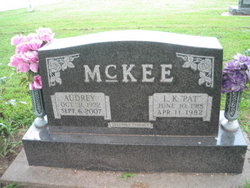
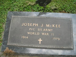
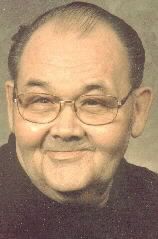
LeRoy Kenneth “Pat” McKee
| Birth | : | 10 Jun 1918 Grant, Montgomery County, Iowa, USA |
| Death | : | 11 Apr 1982 Red Oak, Montgomery County, Iowa, USA |
| Burial | : | St. Mary's Churchyard, Sand Hutton, Ryedale District, England |
| Coordinate | : | 54.0183800, -0.9410700 |
| Plot | : | 2nd Addition #33 |
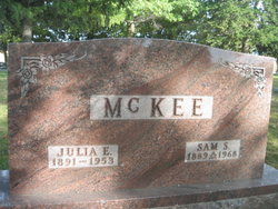
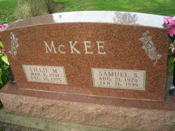
| Description | : | LeRoy Kenneth “Pat” McKee, son of Samuel Sullivan McKee and Julia Elizabeth Trued, was born June 10, 1918 in Grant, Iowa and died April 1982 in Red Oak, Iowa. He married Audrey I. Shook on March 15, 1941 in Rockport, Missouri. They lived in Red Oak the majority of their married life |
frequently asked questions (FAQ):
-
Where is LeRoy Kenneth “Pat” McKee's memorial?
LeRoy Kenneth “Pat” McKee's memorial is located at: St. Mary's Churchyard, Sand Hutton, Ryedale District, England.
-
When did LeRoy Kenneth “Pat” McKee death?
LeRoy Kenneth “Pat” McKee death on 11 Apr 1982 in Red Oak, Montgomery County, Iowa, USA
-
Where are the coordinates of the LeRoy Kenneth “Pat” McKee's memorial?
Latitude: 54.0183800
Longitude: -0.9410700
Family Members:
Parent

Spouse
Siblings
Children

Flowers:


Nearby Cemetories:
1. St. Mary's Churchyard
Sand Hutton, Ryedale District, England
Coordinate: 54.0183800, -0.9410700
2. St Peter Churchyard
Upper Helmsley, Ryedale District, England
Coordinate: 54.0044650, -0.9409770
3. St Botolph Churchyard
Bossall, Ryedale District, England
Coordinate: 54.0375570, -0.9047540
4. St. Mary's Churchyard
Gate Helmsley, Ryedale District, England
Coordinate: 53.9883720, -0.9481980
5. St Mary Churchyard
Warthill, Ryedale District, England
Coordinate: 53.9887610, -0.9714450
6. St Lawrence Churchyard
Flaxton, Ryedale District, England
Coordinate: 54.0508680, -0.9624500
7. St John the Evangelist Churchyard
Buttercrambe, Ryedale District, England
Coordinate: 54.0137300, -0.8812900
8. St Peter and St Paul Churchyard
Scrayingham, Ryedale District, England
Coordinate: 54.0342510, -0.8826130
9. St Peter Churchyard
Stockton-on-the-Forest, York Unitary Authority, England
Coordinate: 53.9964440, -0.9991290
10. Holy Trinity Churchyard
Stockton-on-the-Forest, York Unitary Authority, England
Coordinate: 53.9960220, -0.9994630
11. All Saints Churchyard
Low Catton, East Riding of Yorkshire Unitary Authority, England
Coordinate: 53.9769280, -0.9268720
12. Holy Trinity Churchyard
Holtby, York Unitary Authority, England
Coordinate: 53.9792890, -0.9719310
13. Howsham Churchyard
Howsham, Ryedale District, England
Coordinate: 54.0565520, -0.8755670
14. St Mary Churchyard
Full Sutton, East Riding of Yorkshire Unitary Authority, England
Coordinate: 53.9897620, -0.8613700
15. Dunnington Cemetery
Dunnington, York Unitary Authority, England
Coordinate: 53.9675110, -0.9823760
16. St Nicholas Churchyard
Dunnington, York Unitary Authority, England
Coordinate: 53.9661680, -0.9829590
17. All Saints Churchyard
Foston, Ryedale District, England
Coordinate: 54.0775719, -0.9331510
18. St Mary the Virgin Churchyard
Strensall, York Unitary Authority, England
Coordinate: 54.0389130, -1.0394910
19. St Michael Churchyard
Crambe, Ryedale District, England
Coordinate: 54.0744550, -0.8809390
20. Saint James Churchyard
Murton, York Unitary Authority, England
Coordinate: 53.9656390, -1.0125031
21. St Paul Churchyard
Kexby, York Unitary Authority, England
Coordinate: 53.9505970, -0.9339900
22. St Andrew Churchyard
Bugthorpe, East Riding of Yorkshire Unitary Authority, England
Coordinate: 54.0108100, -0.8226900
23. Kirkham Priory
Kirkham, Ryedale District, England
Coordinate: 54.0826180, -0.8768470
24. All Saints Churchyard
Huntington, York Unitary Authority, England
Coordinate: 53.9977460, -1.0633490