

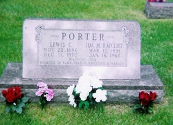
Lewis Cleveland Porter
| Birth | : | 22 Nov 1886 USA |
| Death | : | 11 Dec 1970 Hopkinton, Delaware County, Iowa, USA |
| Burial | : | Wheatley Lane Methodist Churchyard, Fence, Pendle Borough, England |
| Coordinate | : | 53.8341457, -2.2596202 |
| Description | : | Lewis CLeveland Porter was the son of Charlotte Ann Bacon & Edward A. Porter. He married Ida Mae Ratcliff in 1914 in Delaware county, IA. Together they had 4 children. |
frequently asked questions (FAQ):
-
Where is Lewis Cleveland Porter's memorial?
Lewis Cleveland Porter's memorial is located at: Wheatley Lane Methodist Churchyard, Fence, Pendle Borough, England.
-
When did Lewis Cleveland Porter death?
Lewis Cleveland Porter death on 11 Dec 1970 in Hopkinton, Delaware County, Iowa, USA
-
Where are the coordinates of the Lewis Cleveland Porter's memorial?
Latitude: 53.8341457
Longitude: -2.2596202
Family Members:
Parent

Spouse
Siblings
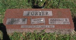
Children
Flowers:


Nearby Cemetories:
1. Wheatley Lane Methodist Churchyard
Fence, Pendle Borough, England
Coordinate: 53.8341457, -2.2596202
2. St. Anne Churchyard
Fence, Pendle Borough, England
Coordinate: 53.8304372, -2.2679552
3. Wheatley Lane Inghamite Church Churchyard
Wheatley Lane, Pendle Borough, England
Coordinate: 53.8412800, -2.2457100
4. St. Mary's Churchyard
Newchurch in Pendle, Pendle Borough, England
Coordinate: 53.8504181, -2.2706807
5. All Souls Cemetery
Barrowford, Pendle Borough, England
Coordinate: 53.8462900, -2.2355600
6. St John Churchyard
Higham, Pendle Borough, England
Coordinate: 53.8251420, -2.2898120
7. Marsden Friends Burial Ground
Marsden, Metropolitan Borough of Kirklees, England
Coordinate: 53.8241910, -2.2197410
8. St. Paul's Churchyard
Nelson, Pendle Borough, England
Coordinate: 53.8289250, -2.2157520
9. St. Thomas Churchyard
Barrowford, Pendle Borough, England
Coordinate: 53.8513900, -2.2196600
10. Barrowford Cemetery
Nelson, Pendle Borough, England
Coordinate: 53.8521100, -2.2130300
11. St. John the Evangelist Churchyard
Nelson, Pendle Borough, England
Coordinate: 53.8367000, -2.1977200
12. Nelson Cemetery
Nelson, Pendle Borough, England
Coordinate: 53.8420330, -2.1972230
13. Ebenezer Baptist Chapel Chapelyard
Burnley, Burnley Borough, England
Coordinate: 53.7975120, -2.2397260
14. St. James' Churchyard
Briercliffe, Burnley Borough, England
Coordinate: 53.8107700, -2.2031800
15. All Saints Churchyard
Habergham Eaves, Burnley Borough, England
Coordinate: 53.7971060, -2.2913770
16. Haggate Baptist Church Burial Ground
Burnley Borough, England
Coordinate: 53.8145048, -2.1960725
17. St. Peter's Churchyard
Burnley, Burnley Borough, England
Coordinate: 53.7924450, -2.2394890
18. Saint Nicholas Parish Churchyard
Sabden, Ribble Valley Borough, England
Coordinate: 53.8346503, -2.3332764
19. Holy Trinity Churchyard
Burnley, Burnley Borough, England
Coordinate: 53.7898290, -2.2574200
20. St. James' Churchyard
Burnley, Burnley Borough, England
Coordinate: 53.7905590, -2.2458280
21. Hill Lane Baptist Church Churchyard
Briercliffe, Burnley Borough, England
Coordinate: 53.8161467, -2.1875368
22. St. Leonard's Churchyard
Padiham, Burnley Borough, England
Coordinate: 53.8022600, -2.3164300
23. Wesleyan Methodist Chapel Chapelyard
Padiham, Burnley Borough, England
Coordinate: 53.8018980, -2.3181730
24. St Leonard Churchyard Extension
Padiham, Burnley Borough, England
Coordinate: 53.7991800, -2.3222000