

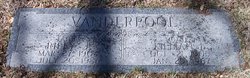
Lillian Idella Clark Vanderpool
| Birth | : | 2 Oct 1905 |
| Death | : | 29 Jan 1967 |
| Burial | : | Church and Clayton-le-Moors Cemetery, Accrington, Hyndburn Borough, England |
| Coordinate | : | 53.7630200, -2.3804820 |
| Plot | : | C, 110, 1 |
| Description | : | Wife of James Riley Vanderpool a/k/a Riley J. Vanderpool. Cemetery Sexton lists her as Lillian T. Vanderpool. Daughter of Sedgwick R Clark and Lillian M (LNU). Mrs. Lillian Vanderpool, 61, 2322 Avenue C, died Sunday at a local hospital after an extended illness.Born at Primrose, NE, she had resided 45 years in Council Bluffs. She was a member of First Baptist Church, White Shrine of Jerusalem and Council Bluffs Assembly 82, Social Order of the Beaceant. Mrs. Vanderpool was employed by First Federal Savings and Loan Association. Survivors include: Husband, Riley; daughter, Mrs. Jean Newell of Edina, MN; son, James R.... Read More |
frequently asked questions (FAQ):
-
Where is Lillian Idella Clark Vanderpool's memorial?
Lillian Idella Clark Vanderpool's memorial is located at: Church and Clayton-le-Moors Cemetery, Accrington, Hyndburn Borough, England.
-
When did Lillian Idella Clark Vanderpool death?
Lillian Idella Clark Vanderpool death on 29 Jan 1967 in
-
Where are the coordinates of the Lillian Idella Clark Vanderpool's memorial?
Latitude: 53.7630200
Longitude: -2.3804820
Family Members:
Parent

Spouse
Siblings
Children
Flowers:


Nearby Cemetories:
1. Church and Clayton-le-Moors Cemetery
Accrington, Hyndburn Borough, England
Coordinate: 53.7630200, -2.3804820
2. St James Churchyard
Church, Hyndburn Borough, England
Coordinate: 53.7574640, -2.3942660
3. All Saints Churchyard
Clayton-le-Moors, Hyndburn Borough, England
Coordinate: 53.7738520, -2.3881690
4. Barnes Square Weslyan Methodist Churchyard
Clayton-le-Moors, Hyndburn Borough, England
Coordinate: 53.7744350, -2.3853800
5. St. James' Parish Church
Accrington, Hyndburn Borough, England
Coordinate: 53.7519900, -2.3652600
6. St Marys Burial Ground
Clayton-le-Moors, Hyndburn Borough, England
Coordinate: 53.7792778, -2.3705871
7. Accrington Cemetery and Crematorium
Accrington, Hyndburn Borough, England
Coordinate: 53.7623787, -2.3508649
8. Christ Church Churchyard
Accrington, Hyndburn Borough, England
Coordinate: 53.7478560, -2.3605820
9. Great Harwood Cemetery
Great Harwood, Hyndburn Borough, England
Coordinate: 53.7796190, -2.4091680
10. Our Lady and Saint Hubert
Great Harwood, Hyndburn Borough, England
Coordinate: 53.7851070, -2.4009760
11. New Lane Baptist Chapel Chapelyard
Oswaldwistle, Hyndburn Borough, England
Coordinate: 53.7381100, -2.4049500
12. St. Bartholomew's Churchyard
Great Harwood, Hyndburn Borough, England
Coordinate: 53.7900670, -2.4055460
13. Immanuel Churchyard
Oswaldwistle, Hyndburn Borough, England
Coordinate: 53.7358300, -2.4056200
14. St. John the Baptist Churchyard
Baxenden, Hyndburn Borough, England
Coordinate: 53.7346500, -2.3470230
15. St James Church
Altham, Hyndburn Borough, England
Coordinate: 53.7928940, -2.3465250
16. St Margaret Churchyard
Hapton, Burnley Borough, England
Coordinate: 53.7802400, -2.3169230
17. St. John's Churchyard
Read, Ribble Valley Borough, England
Coordinate: 53.8088800, -2.3585600
18. St Leonard Churchyard Extension
Padiham, Burnley Borough, England
Coordinate: 53.7991800, -2.3222000
19. St. John's Cemetery
Padiham, Burnley Borough, England
Coordinate: 53.7948720, -2.3145290
20. Wesleyan Methodist Chapel Chapelyard
Padiham, Burnley Borough, England
Coordinate: 53.8018980, -2.3181730
21. St. Leonard's Churchyard
Padiham, Burnley Borough, England
Coordinate: 53.8022600, -2.3164300
22. Blackburn Cemetery
Blackburn, Blackburn with Darwen Unitary Authority, England
Coordinate: 53.7662430, -2.4726050
23. St Alban's Churchyard
Blackburn, Blackburn with Darwen Unitary Authority, England
Coordinate: 53.7530090, -2.4748540
24. Holy Trinity Church
Blackburn with Darwen Unitary Authority, England
Coordinate: 53.7511727, -2.4747178