
| Birth | : | 25 Jan 1913 USA |
| Death | : | 16 Feb 2001 Union County, South Carolina, USA |
| Burial | : | Burnley Cemetery, Burnley, Burnley Borough, England |
| Coordinate | : | 53.7821730, -2.2795070 |
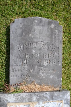
| Description | : | UNION - Lillie Mae Farr Davis, 88, of Oakmont Retirement Center, formerly of 403 Springdale Drive, died Feb. 16, 2001, at Wallace Thomson Hospital. A native of the Kelton Community in Union County, she was the widow of Bennie V. Davis, daughter of the late David Farr and Minnie Bentley Farr Alman and stepdaughter of the late Marvin Alman. She was a member of Buffalo United Methodist Church and was retired from United Merchants at the Union Plant. Survivors include three sisters, Alsie Inman of Union and Louise Farr and Lucille Fowler, both of... Read More |
frequently asked questions (FAQ):
-
Where is Lillie Mae Farr Davis's memorial?
Lillie Mae Farr Davis's memorial is located at: Burnley Cemetery, Burnley, Burnley Borough, England.
-
When did Lillie Mae Farr Davis death?
Lillie Mae Farr Davis death on 16 Feb 2001 in Union County, South Carolina, USA
-
Where are the coordinates of the Lillie Mae Farr Davis's memorial?
Latitude: 53.7821730
Longitude: -2.2795070
Family Members:
Parent

Spouse
Siblings
Flowers:


Nearby Cemetories:
1. Burnley Cemetery
Burnley, Burnley Borough, England
Coordinate: 53.7821730, -2.2795070
2. Burnley Crematorium
Burnley, Burnley Borough, England
Coordinate: 53.7821730, -2.2795070
3. Holy Trinity Churchyard
Burnley, Burnley Borough, England
Coordinate: 53.7898290, -2.2574200
4. All Saints Churchyard
Habergham Eaves, Burnley Borough, England
Coordinate: 53.7971060, -2.2913770
5. St. James' Churchyard
Burnley, Burnley Borough, England
Coordinate: 53.7905590, -2.2458280
6. St Margaret Churchyard
Hapton, Burnley Borough, England
Coordinate: 53.7802400, -2.3169230
7. St. John's Cemetery
Padiham, Burnley Borough, England
Coordinate: 53.7948720, -2.3145290
8. St. Peter's Churchyard
Burnley, Burnley Borough, England
Coordinate: 53.7924450, -2.2394890
9. Ebenezer Baptist Chapel Chapelyard
Burnley, Burnley Borough, England
Coordinate: 53.7975120, -2.2397260
10. St. Leonard's Churchyard
Padiham, Burnley Borough, England
Coordinate: 53.8022600, -2.3164300
11. Wesleyan Methodist Chapel Chapelyard
Padiham, Burnley Borough, England
Coordinate: 53.8018980, -2.3181730
12. St Leonard Churchyard Extension
Padiham, Burnley Borough, England
Coordinate: 53.7991800, -2.3222000
13. Providence Free United Methodist Graveyard
Crawshawbooth, Rossendale Borough, England
Coordinate: 53.7442070, -2.2825700
14. St James Church
Altham, Hyndburn Borough, England
Coordinate: 53.7928940, -2.3465250
15. St John Churchyard
Higham, Pendle Borough, England
Coordinate: 53.8251420, -2.2898120
16. Accrington Cemetery and Crematorium
Accrington, Hyndburn Borough, England
Coordinate: 53.7623787, -2.3508649
17. Rehoboth Chapel
Goodshaw, Rossendale Borough, England
Coordinate: 53.7355870, -2.2914730
18. St. Anne Churchyard
Fence, Pendle Borough, England
Coordinate: 53.8304372, -2.2679552
19. Goodshaw Particular Baptist Chapel Graveyard
Goodshaw, Rossendale Borough, England
Coordinate: 53.7328210, -2.2815530
20. St. Mary and All Saints Churchyard
Goodshaw, Rossendale Borough, England
Coordinate: 53.7315270, -2.2828940
21. Wheatley Lane Methodist Churchyard
Fence, Pendle Borough, England
Coordinate: 53.8341457, -2.2596202
22. St. James' Churchyard
Briercliffe, Burnley Borough, England
Coordinate: 53.8107700, -2.2031800
23. St. John's Churchyard
Read, Ribble Valley Borough, England
Coordinate: 53.8088800, -2.3585600
24. St Marys Burial Ground
Clayton-le-Moors, Hyndburn Borough, England
Coordinate: 53.7792778, -2.3705871