
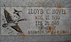
Lloyd Clair Hovel
| Birth | : | 27 Aug 1930 Plymouth, Cerro Gordo County, Iowa, USA |
| Death | : | 26 Feb 1995 Plymouth, Cerro Gordo County, Iowa, USA |
| Burial | : | Redhill Cemetery, Arnold, Nottingham Unitary Authority, England |
| Coordinate | : | 53.0066910, -1.1382950 |
| Plot | : | NW quadrant, Block 2, Lot 19 |
| Inscription | : | Father of Barbara, Sandy & David |
| Description | : | Spouse: Mary Hovel Lloyd was married then later divorced. Lloyd & his wife Mary were blessed with 3 children. David, Barbara, & Sandy. Lloyd was the kind of person who was very easy going & very quiet. He enjoyed riding his motorcycle with his friends. Not sure if Lloyd was born at home. In the days at that time the family had their babies at home. Lloyd was raised on his dad's farm at Plymouth. If you have any pictures you can add & a flower & a message for Lloyd... Read More |
frequently asked questions (FAQ):
-
Where is Lloyd Clair Hovel's memorial?
Lloyd Clair Hovel's memorial is located at: Redhill Cemetery, Arnold, Nottingham Unitary Authority, England.
-
When did Lloyd Clair Hovel death?
Lloyd Clair Hovel death on 26 Feb 1995 in Plymouth, Cerro Gordo County, Iowa, USA
-
Where are the coordinates of the Lloyd Clair Hovel's memorial?
Latitude: 53.0066910
Longitude: -1.1382950
Family Members:
Parent
Siblings

Flowers:


Nearby Cemetories:
1. Redhill Cemetery
Arnold, Nottingham Unitary Authority, England
Coordinate: 53.0066910, -1.1382950
2. St. John's Carrington Churchyard
Nottingham, Nottingham Unitary Authority, England
Coordinate: 52.9755350, -1.1506790
3. Basford Cemetery
Old Basford, Nottingham Unitary Authority, England
Coordinate: 52.9799700, -1.1725900
4. St. Leodegarius Churchyard
Old Basford, Nottingham Unitary Authority, England
Coordinate: 52.9794240, -1.1778650
5. Gedling Cemetery
Gedling, Gedling Borough, England
Coordinate: 52.9806930, -1.0870670
6. St. Paul's Churchyard
Nottingham Unitary Authority, England
Coordinate: 52.9667590, -1.1172140
7. Northern Cemetery
Bulwell, Nottingham Unitary Authority, England
Coordinate: 52.9979840, -1.2077900
8. Hucknall Cemetery
Hucknall, Ashfield District, England
Coordinate: 53.0293427, -1.1988190
9. Nottingham Church Cemetery
Nottingham, Nottingham Unitary Authority, England
Coordinate: 52.9649830, -1.1558070
10. All Hallows Churchyard
Gedling, Gedling Borough, England
Coordinate: 52.9769400, -1.0805130
11. Hardy Street Jewish Cemetery
Nottingham, Nottingham Unitary Authority, England
Coordinate: 52.9619500, -1.1665900
12. Carlton Cemetery
Nottingham, Nottingham Unitary Authority, England
Coordinate: 52.9682820, -1.0900230
13. St. Mary Rest Ground
Nottingham, Nottingham Unitary Authority, England
Coordinate: 52.9568310, -1.1406580
14. Nottingham General Cemetery
Nottingham, Nottingham Unitary Authority, England
Coordinate: 52.9575370, -1.1594236
15. Woodborough Cemetery
Woodborough, Gedling Borough, England
Coordinate: 53.0272840, -1.0600540
16. St. Mary Magdalene Churchyard
Hucknall, Ashfield District, England
Coordinate: 53.0390630, -1.2058330
17. General Cemetery
Nottingham, Nottingham Unitary Authority, England
Coordinate: 52.9561430, -1.1615420
18. St. Peter Churchyard Old Radford
Nottingham, Nottingham Unitary Authority, England
Coordinate: 52.9601830, -1.1789620
19. Cathedral Church of St. Barnabas
Nottingham, Nottingham Unitary Authority, England
Coordinate: 52.9546750, -1.1570460
20. National Ice Centre
Nottingham, Nottingham Unitary Authority, England
Coordinate: 52.9527790, -1.1394460
21. St Mary's Burial Grounds
Nottingham, Nottingham Unitary Authority, England
Coordinate: 52.9527860, -1.1419160
22. St Peters Church Yard
Nottingham, Nottingham Unitary Authority, England
Coordinate: 52.9522800, -1.1486940
23. National Justice Museum High Pavement Nottingham
Nottingham Unitary Authority, England
Coordinate: 52.9510680, -1.1443050
24. St Nicholas Churchyard
Nottingham, Nottingham Unitary Authority, England
Coordinate: 52.9504780, -1.1509220