
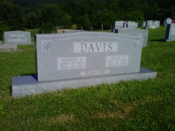
| Birth | : | 24 Jan 1926 USA |
| Death | : | 19 Jan 2002 USA |
| Burial | : | Cabin Creek Cemetery, Grayson County, USA |
| Coordinate | : | 36.6116000, -81.5218000 |
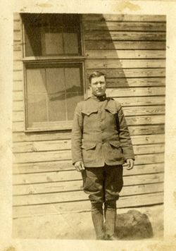
| Description | : | Lonnie Ray Davis, 75, of Alexandria, formerly of Mouth of Wilson, the Cabin Creek Community, Died Jan. 19,2002m at his home. He was born Jan.24, 1926, to Marion Alonzo and Olga Osborne Davis. Survivors include his wife, Esther Davis of the home; a daughter and son-in-law, Elizabeth "Betty Lou" and James Benson of Fairfax; two grandchildren; and three great-grandchildren. A funeral will be held today, Wednesday, at 11 a.m. at Faith Lutheran Church, Whitetop, with burial in the Cabin Creek Cemetery, Mouth of Wilson. Pastor Wil Robertson will officiate. Military rites will be conducted by the Grayson County VFW Post 7726. Reins-Sturdivant... Read More |
frequently asked questions (FAQ):
-
Where is Lonnie Ray Davis's memorial?
Lonnie Ray Davis's memorial is located at: Cabin Creek Cemetery, Grayson County, USA.
-
When did Lonnie Ray Davis death?
Lonnie Ray Davis death on 19 Jan 2002 in USA
-
Where are the coordinates of the Lonnie Ray Davis's memorial?
Latitude: 36.6116000
Longitude: -81.5218000
Family Members:
Parent
Spouse

Flowers:


Nearby Cemetories:
1. Cabin Creek Cemetery
Grayson County, USA
Coordinate: 36.6116000, -81.5218000
2. Osborne Cemetery
Grayson County, USA
Coordinate: 36.6119003, -81.5216980
3. Greer Cemetery
Grayson County, USA
Coordinate: 36.6180992, -81.5243988
4. Fees Ridge Cemetery
Mouth of Wilson, Grayson County, USA
Coordinate: 36.5936130, -81.5113800
5. Haw Orchard Cemetery
Grayson County, USA
Coordinate: 36.6081009, -81.4950027
6. Lewis-Perry Cemetery
Grayson County, USA
Coordinate: 36.5849991, -81.5355988
7. Kilby Cemetery
Grayson County, USA
Coordinate: 36.5825005, -81.5092010
8. Duvall Family Cemetery
Grayson County, USA
Coordinate: 36.5942130, -81.4864020
9. Roop Cemetery
Grayson County, USA
Coordinate: 36.5868988, -81.5505981
10. Marshel Jones Cemetery
Rugby, Grayson County, USA
Coordinate: 36.6279230, -81.4816490
11. Timothy F Young Cemetery
Rugby, Grayson County, USA
Coordinate: 36.5955220, -81.4797870
12. Richardson Family Cemetery
Rugby, Grayson County, USA
Coordinate: 36.5975760, -81.4766480
13. Elijah Franklin Sexton Family Cemetery
Mill Creek, Grayson County, USA
Coordinate: 36.6156371, -81.4691845
14. Gideon Weaver Cemetery
Rugby, Grayson County, USA
Coordinate: 36.6156830, -81.4691750
15. Phipps Cemetery
Grayson County, USA
Coordinate: 36.5850830, -81.4794240
16. Roby Testerman Family Cemetery
Mouth of Wilson, Grayson County, USA
Coordinate: 36.5818560, -81.4749340
17. Ambrose Spencer Family Cemetery
Ashe County, USA
Coordinate: 36.5720300, -81.4873300
18. Andrew Hurley Family Cemetery
Ashe County, USA
Coordinate: 36.5633011, -81.5246964
19. Samuel Tucker Family Cemetery
Mouth of Wilson, Grayson County, USA
Coordinate: 36.6092250, -81.4614260
20. Abram Reedy Cemetery
Rugby, Grayson County, USA
Coordinate: 36.5958220, -81.4602810
21. Barnes Cemetery
Rugby, Grayson County, USA
Coordinate: 36.5847700, -81.4625570
22. Bill Reedy Cemetery
Rugby, Grayson County, USA
Coordinate: 36.5943000, -81.4571000
23. John Weiss Cemetery
Rugby, Grayson County, USA
Coordinate: 36.5809630, -81.4629810
24. Corinth Baptist Church Cemetery
Rugby, Grayson County, USA
Coordinate: 36.6119240, -81.4470280