
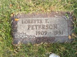
Loretta Florence Sunday Peterson
| Birth | : | 15 Jun 1909 Havre, Hill County, Montana, USA |
| Death | : | 12 Apr 1991 Havre, Hill County, Montana, USA |
| Burial | : | Calvary Cemetery, Havre, Hill County, USA |
| Coordinate | : | 48.5457000, -109.6883000 |
| Plot | : | Lot 5 Block 10 |
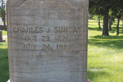
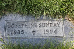
| Description | : | Havre Daily News April 1991 Loretta F. (Sunday) Peterson, 81, of Havre, died April 12 at a Havre hospital. A Rosary is scheduled this evening at 7 at Holland and Bonine Funeral Chapel in Havre, with Father J. Patrick Stewart officiating. A funeral Mass is scheduled Tuesday at 10 a.m. at St. Jude's Catholic Church with Father Stewart officiating. Burial will be in Calvary Cemetery. She was born Jun15,1909, in Havre to Charles and Josephine Sunday. She attended Havre High School and graduated in 1928, She... Read More |
frequently asked questions (FAQ):
-
Where is Loretta Florence Sunday Peterson's memorial?
Loretta Florence Sunday Peterson's memorial is located at: Calvary Cemetery, Havre, Hill County, USA.
-
When did Loretta Florence Sunday Peterson death?
Loretta Florence Sunday Peterson death on 12 Apr 1991 in Havre, Hill County, Montana, USA
-
Where are the coordinates of the Loretta Florence Sunday Peterson's memorial?
Latitude: 48.5457000
Longitude: -109.6883000
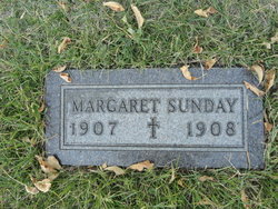
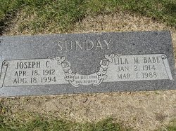
Family Members:
Parent
Spouse
Siblings
Flowers:


Nearby Cemetories:
1. Calvary Cemetery
Havre, Hill County, USA
Coordinate: 48.5457000, -109.6883000
2. Highland Cemetery
Havre, Hill County, USA
Coordinate: 48.5463982, -109.6900024
3. Mount Hope Cemetery
Havre, Hill County, USA
Coordinate: 48.5540000, -109.7050000
4. Sunset Garden Park
Havre, Hill County, USA
Coordinate: 48.5531006, -109.8019028
5. North Havre Lutheran Church Graveyard (Defunct)
Havre, Hill County, USA
Coordinate: 48.6538903, -109.6815870
6. Grainbelt Cemetery
Hill County, USA
Coordinate: 48.6828003, -109.8657990
7. Andrew S. Lohman Grave Site
Lohman, Blaine County, USA
Coordinate: 48.5903520, -109.4073350
8. East End Colony Cemetery
East End Colony, Hill County, USA
Coordinate: 48.7485000, -109.5474000
9. Hilldale Hutterite Colony Cemetery
Hilldale Colony, Hill County, USA
Coordinate: 48.7997000, -109.7872000
10. Saint Johns Catholic Cemetery
Havre, Hill County, USA
Coordinate: 48.7625008, -109.9638977
11. Saint Gabriel Cemetery
Chinook, Blaine County, USA
Coordinate: 48.6065200, -109.2531200
12. Kuper Memorial Cemetery
Chinook, Blaine County, USA
Coordinate: 48.6083100, -109.2531200
13. Rocky Boy Cemetery
Rocky Boy, Hill County, USA
Coordinate: 48.2572410, -109.7923690
14. Box Elder Cemetery
Box Elder, Hill County, USA
Coordinate: 48.3274000, -110.0095000
15. Rocky Boy Gravel Cemetery
Rocky Boy, Hill County, USA
Coordinate: 48.2427720, -109.7596500
16. Cottonwood Lutheran Church Cemetery
Havre, Hill County, USA
Coordinate: 48.4545000, -110.1748000
17. Bear Paw Battlefield
Chinook, Blaine County, USA
Coordinate: 48.3780070, -109.2121290
18. Hungry Hollow Cemetery
Blaine County, USA
Coordinate: 48.2103004, -109.4677963
19. Milk River Valley Church Graveyard
Hill County, USA
Coordinate: 48.6787180, -110.2261080
20. Hollandville Cemetery
Chinook, Blaine County, USA
Coordinate: 48.6960310, -109.1557200
21. Gildford Hill County Cemetery
Gildford, Hill County, USA
Coordinate: 48.5778008, -110.2957993
22. Prairie Chapel United Brethren Cemetery
Chinook, Blaine County, USA
Coordinate: 48.8860000, -109.3414000
23. Mennonite Brethren Cemetery
Chinook, Blaine County, USA
Coordinate: 48.8012560, -109.1980620
24. Bethel Bruderthaler Mennonite Church Cemetery
Chinook, Blaine County, USA
Coordinate: 48.7552000, -109.1345000