

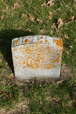
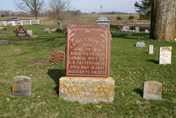
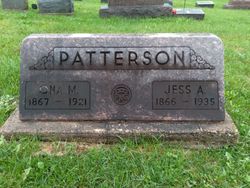
Lorinda Pate Patterson
| Birth | : | 10 Jan 1839 |
| Death | : | 18 May 1907 |
| Burial | : | Saint Paul Churchyard, Great Marton, Blackpool Unitary Authority, England |
| Coordinate | : | 53.8053220, -3.0268330 |
| Plot | : | Row 5, Lot 1E |
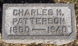
| Description | : | 2nd wife of: Charles Hamilton Patterson. "Died. PATTERSON. - Lorinda Pate, daughter of Jessie and Lucretia Pate, was born in Maquoketa township, Jan. 10, 1839, on what is now known as the John Burke farm and after failing health of two years or more she died of heart failure, May 18, 1907, at the home of her daughter, Nellie Shattuck, aged 68 years, 4 months and 8 days. She was among the first born in the township and very few people are living who lived longer in Iowa than she did. She always lived in the... Read More |
frequently asked questions (FAQ):
-
Where is Lorinda Pate Patterson's memorial?
Lorinda Pate Patterson's memorial is located at: Saint Paul Churchyard, Great Marton, Blackpool Unitary Authority, England.
-
When did Lorinda Pate Patterson death?
Lorinda Pate Patterson death on 18 May 1907 in
-
Where are the coordinates of the Lorinda Pate Patterson's memorial?
Latitude: 53.8053220
Longitude: -3.0268330
Family Members:
Parent

Spouse
Siblings
Children
Flowers:


Nearby Cemetories:
1. Saint Paul Churchyard
Great Marton, Blackpool Unitary Authority, England
Coordinate: 53.8053220, -3.0268330
2. Carlton Cemetery& Crematorium
Blackpool, Blackpool Unitary Authority, England
Coordinate: 53.8095921, -3.0364920
3. Marton Burial Ground
Great Marton, Blackpool Unitary Authority, England
Coordinate: 53.8030870, -3.0108350
4. Holy Trinity Churchyard
Blackpool, Blackpool Unitary Authority, England
Coordinate: 53.7962949, -3.0536214
5. St John the Evangelist Churchyard
Blackpool, Blackpool Unitary Authority, England
Coordinate: 53.8182303, -3.0508197
6. Layton Cemetery
Blackpool, Blackpool Unitary Authority, England
Coordinate: 53.8273740, -3.0328240
7. Blackpool Jewish Cemetery
Blackpool, Blackpool Unitary Authority, England
Coordinate: 53.8287397, -3.0311753
8. St Paul's Church & Medical Centre
Blackpool Unitary Authority, England
Coordinate: 53.8291540, -3.0533490
9. St Stephen On-the-Cliffs Churchyard
Blackpool, Blackpool Unitary Authority, England
Coordinate: 53.8407230, -3.0515610
10. Blackpool Cemetery and Crematorium
Poulton-le-Fylde, Wyre Borough, England
Coordinate: 53.8465680, -3.0196600
11. Saint Chad Churchyard
Poulton-le-Fylde, Wyre Borough, England
Coordinate: 53.8471992, -2.9925005
12. St Anne's Parish Church
St Annes, Fylde Borough, England
Coordinate: 53.7565230, -3.0227100
13. All Hallow's Churchyard
Bispham, Blackpool Unitary Authority, England
Coordinate: 53.8567580, -3.0372160
14. Poulton-Le-Fylde Old Cemetery
Poulton-le-Fylde, Wyre Borough, England
Coordinate: 53.8458145, -2.9713324
15. St Johns Roman Catholic Church Cemetery
Poulton-le-Fylde, Wyre Borough, England
Coordinate: 53.8520854, -2.9873511
16. Poulton New Cemetery
Poulton-le-Fylde, Wyre Borough, England
Coordinate: 53.8461240, -2.9689560
17. St Michael Churchyard
Weeton, Fylde Borough, England
Coordinate: 53.7995380, -2.9358020
18. Lytham Park Cemetery and Crematorium
Lytham Saint Annes, Fylde Borough, England
Coordinate: 53.7534410, -2.9825790
19. St. Anne's Churchyard
Blackburn, Blackburn with Darwen Unitary Authority, England
Coordinate: 53.8381160, -2.9362870
20. St Anne Churchyard
Singleton, Fylde Borough, England
Coordinate: 53.8379280, -2.9359890
21. St. Anne's Roman Catholic Churchyard
Westby, Fylde Borough, England
Coordinate: 53.7876590, -2.9247000
22. St Nicholas Churchyard
Wrea Green, Fylde Borough, England
Coordinate: 53.7772420, -2.9156380
23. Christ Church Thornton Churchyard
Thornton-Cleveleys, Wyre Borough, England
Coordinate: 53.8772800, -3.0221100
24. St. Cuthbert Churchyard
Lytham Saint Annes, Fylde Borough, England
Coordinate: 53.7376560, -2.9761270