
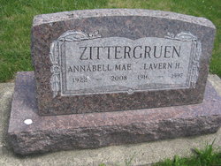
| Birth | : | 18 Feb 1939 Garber, Clayton County, Iowa, USA |
| Death | : | 11 Jun 2007 Dubuque, Dubuque County, Iowa, USA |
| Burial | : | Guttenberg Cemetery, Guttenberg, Clayton County, USA |
| Coordinate | : | 42.7691994, -91.1035995 |
| Inscription | : | Mother of Joel,Todd & Eric Ortman |
| Description | : | Lorna J (Zittergruen) Rommann was born, the daughter of Louis and Elsie (Kruse) Zittergruen, February 18, 1939, on the family farm near Garber. She died Monday, June 11, 2007, at Finley Hospital in Dubuque. Funeral Service: Thursday 10:30 A.M. June 14, 2007 at Trinity Lutheran Church Guttenberg, Iowa Lorna graduated from the Guttenberg High School and attended Wartburg College in Waverly. She owned and operated the Island Marina on Esmann Island for many years. Her other interests were fishing, traveling, and working with flowers. Survivors include her husband, Butch; two sons, Todd (Sandy) Ortman of Brush Prairie, Washington and Eric (Sherri) Ortman... Read More |
frequently asked questions (FAQ):
-
Where is Lorna J. Zittergruen Ortman Rommann's memorial?
Lorna J. Zittergruen Ortman Rommann's memorial is located at: Guttenberg Cemetery, Guttenberg, Clayton County, USA.
-
When did Lorna J. Zittergruen Ortman Rommann death?
Lorna J. Zittergruen Ortman Rommann death on 11 Jun 2007 in Dubuque, Dubuque County, Iowa, USA
-
Where are the coordinates of the Lorna J. Zittergruen Ortman Rommann's memorial?
Latitude: 42.7691994
Longitude: -91.1035995
Family Members:
Parent

Siblings
Flowers:


Nearby Cemetories:
1. Guttenberg Cemetery
Guttenberg, Clayton County, USA
Coordinate: 42.7691994, -91.1035995
2. Mount Olivet Cemetery
Guttenberg, Clayton County, USA
Coordinate: 42.7764840, -91.1083560
3. Saint Johns Cemetery
Jefferson Township, Clayton County, USA
Coordinate: 42.7497000, -91.1133000
4. Saint Marys Cemetery
Guttenberg, Clayton County, USA
Coordinate: 42.7691994, -91.1352997
5. Old Saint Marys Cemetery
Glen Haven, Grant County, USA
Coordinate: 42.8078100, -91.0675330
6. Bierer Cemetery
Millville, Clayton County, USA
Coordinate: 42.7230500, -91.0925166
7. Charlotte Cemetery
Glen Haven, Grant County, USA
Coordinate: 42.7933006, -91.0381012
8. Redman Cemetery
Millville, Clayton County, USA
Coordinate: 42.7166755, -91.0852901
9. Borcherding Cemetery
Jefferson Township, Clayton County, USA
Coordinate: 42.8182983, -91.1414032
10. Storck Cemetery
Guttenberg, Clayton County, USA
Coordinate: 42.7694335, -91.1834638
11. Friedlein Cemetery
Millville, Clayton County, USA
Coordinate: 42.7080994, -91.1108017
12. Lewis Cemetery
Osterdock, Clayton County, USA
Coordinate: 42.7416000, -91.1834000
13. Saint Michael Cemetery
Clayton County, USA
Coordinate: 42.8055992, -91.1802979
14. Duncan Cemetery
Glen Haven, Grant County, USA
Coordinate: 42.8325540, -91.0725940
15. Saint Paula Cemetery
Osterdock, Clayton County, USA
Coordinate: 42.7635994, -91.1992035
16. Gockel Cemetery
Glen Haven, Grant County, USA
Coordinate: 42.8224983, -91.0385971
17. Ramsey Cemetery
North Andover, Grant County, USA
Coordinate: 42.7817001, -90.9972000
18. Bethel Cemetery
Osterdock, Clayton County, USA
Coordinate: 42.7041702, -91.1688919
19. Pioneer Rock Cemetery
Ceres, Clayton County, USA
Coordinate: 42.8230591, -91.1863937
20. Goshen Cemetery
Millville, Clayton County, USA
Coordinate: 42.6905594, -91.0544434
21. Scott Cemetery
Glen Haven, Grant County, USA
Coordinate: 42.8368988, -91.0299988
22. Graham Cemetery
Millville, Clayton County, USA
Coordinate: 42.6833172, -91.1195685
23. Tangeman Family Cemetery
Garnavillo, Clayton County, USA
Coordinate: 42.8580000, -91.1420000
24. McClelland Cemetery
Garnavillo, Clayton County, USA
Coordinate: 42.8249879, -91.2084641