
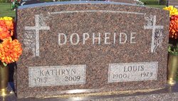
Louis Dopheide
| Birth | : | 12 Sep 1900 Carroll County, Iowa, USA |
| Death | : | 24 May 1979 Carroll, Carroll County, Iowa, USA |
| Burial | : | Dickens Cemetery, Dickens, Dickens County, USA |
| Coordinate | : | 33.6236550, -100.8214260 |
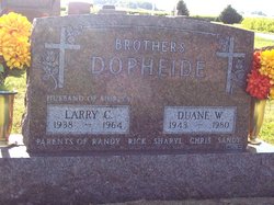
| Description | : | Carroll Daily Times May 25, 1979 P2 Templeton - Mass of the Christian Burial will be conducted at 1:30 p.m. Monday at Sacred Heart Church for Louis H. Dopheide, 78, who died Thursday at his home here.... Mr. Dopheide is survived by his wife Kathryn, a son Duane, two foster daughters: Mrs. Marvin (Anita) Weber, Carroll and Mrs. LaVern (Edna) Trecker, Manning; a daughter-in-law, Mrs. Fred (Shirley) Eischeid, Carroll; a brother, William Dopheide, Dedham, 24 grandchildren and two great-grandchildren. He was preceded in death by his parents, a son Larry on Oct. 2, 1964; his first wife Anna;... Read More |
frequently asked questions (FAQ):
-
Where is Louis Dopheide's memorial?
Louis Dopheide's memorial is located at: Dickens Cemetery, Dickens, Dickens County, USA.
-
When did Louis Dopheide death?
Louis Dopheide death on 24 May 1979 in Carroll, Carroll County, Iowa, USA
-
Where are the coordinates of the Louis Dopheide's memorial?
Latitude: 33.6236550
Longitude: -100.8214260
Family Members:
Parent
Spouse
Siblings

Children
Flowers:


Nearby Cemetories:
1. Dickens Cemetery
Dickens, Dickens County, USA
Coordinate: 33.6236550, -100.8214260
2. Espuela Cemetery
Dickens County, USA
Coordinate: 33.5750008, -100.8949966
3. Mayo Cemetery
Dickens, Dickens County, USA
Coordinate: 33.5970250, -100.7127960
4. Amity Cemetery
Dickens County, USA
Coordinate: 33.7193985, -100.8242035
5. Afton Cemetery
Afton, Dickens County, USA
Coordinate: 33.7658310, -100.8059050
6. Spur Cemetery
Spur, Dickens County, USA
Coordinate: 33.4774704, -100.8379898
7. McAdoo Cemetery
McAdoo, Dickens County, USA
Coordinate: 33.7252998, -101.0214005
8. Steele Hill Cemetery
Spur, Dickens County, USA
Coordinate: 33.4211390, -100.7882370
9. Red Mud Cemetery
Spur, Dickens County, USA
Coordinate: 33.4265120, -100.9987710
10. Mount Zion Cemetery
Crosby County, USA
Coordinate: 33.6533700, -101.1922100
11. Crosbyton Cemetery
Crosbyton, Crosby County, USA
Coordinate: 33.6577988, -101.2099991
12. Antelope Cemetery
Floyd County, USA
Coordinate: 33.8692017, -101.0980988
13. Dougherty Cemetery
Dougherty, Floyd County, USA
Coordinate: 33.9503070, -101.0851670
14. Rock House Cemetery
Mount Blanco, Crosby County, USA
Coordinate: 33.8016080, -101.2487020
15. Lakeview Cemetery
Floyd County, USA
Coordinate: 33.8741989, -101.2577972
16. Ralls Cemetery
Ralls, Crosby County, USA
Coordinate: 33.6732521, -101.4008408
17. Buck Creek Cemetery
Paducah, Cottle County, USA
Coordinate: 33.9322380, -100.3640400
18. Emma Cemetery
Crosby County, USA
Coordinate: 33.6114970, -101.4123950
19. Forest Lawn Cemetery
Floydada, Floyd County, USA
Coordinate: 33.9752600, -101.2729840
20. Cone Cemetery
Cone, Crosby County, USA
Coordinate: 33.7971992, -101.4216995
21. Shinnery Cemetery
Paducah, Cottle County, USA
Coordinate: 33.8483009, -100.2367020
22. Rushing Chapel Cemetery
Floyd County, USA
Coordinate: 34.0558014, -101.2202988
23. Cross H Ranch Cemetery
Post, Garza County, USA
Coordinate: 33.1996620, -101.2539300
24. Floyd County Memorial Park
Floydada, Floyd County, USA
Coordinate: 34.0031600, -101.3262000