
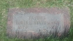
Louis H Aevermann
| Birth | : | 15 Jul 1876 Iowa, USA |
| Death | : | 14 Dec 1952 Havre, Hill County, Montana, USA |
| Burial | : | Highland Cemetery, Havre, Hill County, USA |
| Coordinate | : | 48.5463982, -109.6900024 |
| Plot | : | Space D Lot 55 Block 23 |
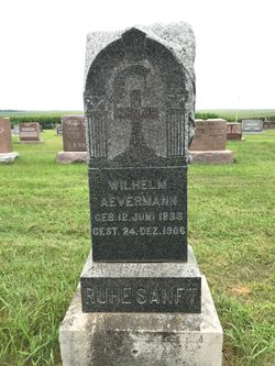
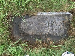
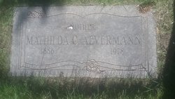
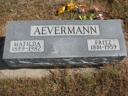
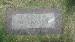
| Description | : | Liberty County Times, Chester, MT, 1 Jan 1953 Louis H. Aevermann, 76, farmer living south and west of Rudyard, died December 14 in a hospital in Havre. Mr. Aevermann was born July 15, 1876, in Iowa, and was married to Mathilda Koch February 25, 1915. Survivors besides Mrs. Aeverman are Clarence of Rudyard and Mrs. Irene Struck of Kalispell, and two grandchildren. Three brothers, Henry of Rudyard, Fritz of Winside, Nebraska, and Paul of Hartinton, Nebraska; sisters, Mrs. Henry Sterlo of Oakland, Nebraska, and Mrs. Henry Claseman of Emerson, Nebraska. Family funeral services were held in the St. John's... Read More |
frequently asked questions (FAQ):
-
Where is Louis H Aevermann's memorial?
Louis H Aevermann's memorial is located at: Highland Cemetery, Havre, Hill County, USA.
-
When did Louis H Aevermann death?
Louis H Aevermann death on 14 Dec 1952 in Havre, Hill County, Montana, USA
-
Where are the coordinates of the Louis H Aevermann's memorial?
Latitude: 48.5463982
Longitude: -109.6900024
Family Members:
Parent
Spouse
Siblings

Children
Flowers:


Nearby Cemetories:
1. Highland Cemetery
Havre, Hill County, USA
Coordinate: 48.5463982, -109.6900024
2. Calvary Cemetery
Havre, Hill County, USA
Coordinate: 48.5457000, -109.6883000
3. Mount Hope Cemetery
Havre, Hill County, USA
Coordinate: 48.5540000, -109.7050000
4. Sunset Garden Park
Havre, Hill County, USA
Coordinate: 48.5531006, -109.8019028
5. North Havre Lutheran Church Graveyard (Defunct)
Havre, Hill County, USA
Coordinate: 48.6538903, -109.6815870
6. Grainbelt Cemetery
Hill County, USA
Coordinate: 48.6828003, -109.8657990
7. Andrew S. Lohman Grave Site
Lohman, Blaine County, USA
Coordinate: 48.5903520, -109.4073350
8. East End Colony Cemetery
East End Colony, Hill County, USA
Coordinate: 48.7485000, -109.5474000
9. Hilldale Hutterite Colony Cemetery
Hilldale Colony, Hill County, USA
Coordinate: 48.7997000, -109.7872000
10. Saint Johns Catholic Cemetery
Havre, Hill County, USA
Coordinate: 48.7625008, -109.9638977
11. Saint Gabriel Cemetery
Chinook, Blaine County, USA
Coordinate: 48.6065200, -109.2531200
12. Kuper Memorial Cemetery
Chinook, Blaine County, USA
Coordinate: 48.6083100, -109.2531200
13. Rocky Boy Cemetery
Rocky Boy, Hill County, USA
Coordinate: 48.2572410, -109.7923690
14. Box Elder Cemetery
Box Elder, Hill County, USA
Coordinate: 48.3274000, -110.0095000
15. Rocky Boy Gravel Cemetery
Rocky Boy, Hill County, USA
Coordinate: 48.2427720, -109.7596500
16. Cottonwood Lutheran Church Cemetery
Havre, Hill County, USA
Coordinate: 48.4545000, -110.1748000
17. Bear Paw Battlefield
Chinook, Blaine County, USA
Coordinate: 48.3780070, -109.2121290
18. Hungry Hollow Cemetery
Blaine County, USA
Coordinate: 48.2103004, -109.4677963
19. Milk River Valley Church Graveyard
Hill County, USA
Coordinate: 48.6787180, -110.2261080
20. Hollandville Cemetery
Chinook, Blaine County, USA
Coordinate: 48.6960310, -109.1557200
21. Gildford Hill County Cemetery
Gildford, Hill County, USA
Coordinate: 48.5778008, -110.2957993
22. Prairie Chapel United Brethren Cemetery
Chinook, Blaine County, USA
Coordinate: 48.8860000, -109.3414000
23. Mennonite Brethren Cemetery
Chinook, Blaine County, USA
Coordinate: 48.8012560, -109.1980620
24. Bethel Bruderthaler Mennonite Church Cemetery
Chinook, Blaine County, USA
Coordinate: 48.7552000, -109.1345000