
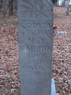

Louisa Lewis Barron
| Birth | : | 16 Jan 1867 St. Francois County, Missouri, USA |
| Death | : | 30 Jul 1908 Cross Roads, St. Francois County, Missouri, USA |
| Burial | : | Bohemian Cemetery, Richardson County, USA |
| Coordinate | : | 40.1175003, -95.9955978 |
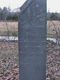
| Description | : | Wife of Nicholas Jefferson Barron Married Dec 30 1886 Madison County, Missouri |
frequently asked questions (FAQ):
-
Where is Louisa Lewis Barron's memorial?
Louisa Lewis Barron's memorial is located at: Bohemian Cemetery, Richardson County, USA.
-
When did Louisa Lewis Barron death?
Louisa Lewis Barron death on 30 Jul 1908 in Cross Roads, St. Francois County, Missouri, USA
-
Where are the coordinates of the Louisa Lewis Barron's memorial?
Latitude: 40.1175003
Longitude: -95.9955978
Family Members:
Parent

Spouse
Siblings
Children
Flowers:


Nearby Cemetories:
1. Bohemian Cemetery
Richardson County, USA
Coordinate: 40.1175003, -95.9955978
2. Dry Branch Pioneer Cemetery
Richardson County, USA
Coordinate: 40.1292000, -96.0100021
3. Humboldt Cemetery
Humboldt, Richardson County, USA
Coordinate: 40.1610985, -95.9578018
4. Bohemian Cemetery
Table Rock, Pawnee County, USA
Coordinate: 40.1786003, -96.0374985
5. Lynchburg Cemetery
Humboldt, Richardson County, USA
Coordinate: 40.1306000, -95.9068985
6. East Amish Cemetery
Table Rock, Pawnee County, USA
Coordinate: 40.1310000, -96.0854000
7. Four Mile Cemetery
Humboldt, Richardson County, USA
Coordinate: 40.0589000, -95.9455000
8. Athens Cemetery
Richardson County, USA
Coordinate: 40.0449982, -95.9852982
9. Longbranch Cemetery
Humboldt, Richardson County, USA
Coordinate: 40.1996000, -95.9740000
10. Standerford Cemetery
Humboldt, Richardson County, USA
Coordinate: 40.2110000, -95.9656000
11. Pleasant Hill Cemetery
Richardson County, USA
Coordinate: 40.0471992, -95.9075012
12. Starr Cemetery
Dawson, Richardson County, USA
Coordinate: 40.1464005, -95.8692017
13. DuBois Cemetery
Du Bois, Pawnee County, USA
Coordinate: 40.0231018, -96.0488968
14. Table Rock Cemetery
Table Rock, Pawnee County, USA
Coordinate: 40.1791400, -96.1037400
15. Saint Johns Cemetery
Table Rock, Pawnee County, USA
Coordinate: 40.2148000, -96.0657000
16. Cincinnati Cemetery
Du Bois, Pawnee County, USA
Coordinate: 40.0042000, -96.0274963
17. Saint Marys Cemetery
Dawson, Richardson County, USA
Coordinate: 40.1307983, -95.8414001
18. Prairie Star Pioneer Cemetery
Du Bois, Pawnee County, USA
Coordinate: 40.0293000, -96.1041000
19. Heim Cemetery
Dawson, Richardson County, USA
Coordinate: 40.1380997, -95.8328018
20. Pawnee City Cemetery
Pawnee City, Pawnee County, USA
Coordinate: 40.1109009, -96.1608810
21. Mound Cemetery
Humboldt, Richardson County, USA
Coordinate: 40.1960983, -95.8602982
22. Evergreen Cemetery
Pawnee County, USA
Coordinate: 40.0485992, -96.1417007
23. Friedens United Church of Christ Cemetery
Bern, Nemaha County, USA
Coordinate: 39.9929008, -96.0529480
24. Four Mile Cemetery
Bern, Nemaha County, USA
Coordinate: 39.9857900, -95.9568900