
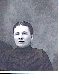
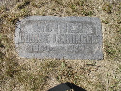
Louise Dorothea Christine Stolte Leininger
| Birth | : | 8 May 1850 Hanover, Region Hannover, Lower Saxony (Niedersachsen), Germany |
| Death | : | 21 Jun 1927 Wheaton, Traverse County, Minnesota, USA |
| Burial | : | St Mary's Church, Grafton Regis, South Northamptonshire Borough, England |
| Coordinate | : | 52.1154430, -0.8931010 |
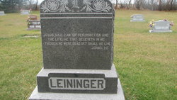
| Inscription | : | Mother Jesus said, I am the resurrection, and the life: He that believeth in me, though he were dead, yet shall he live. John 11:25 |
frequently asked questions (FAQ):
-
Where is Louise Dorothea Christine Stolte Leininger's memorial?
Louise Dorothea Christine Stolte Leininger's memorial is located at: St Mary's Church, Grafton Regis, South Northamptonshire Borough, England.
-
When did Louise Dorothea Christine Stolte Leininger death?
Louise Dorothea Christine Stolte Leininger death on 21 Jun 1927 in Wheaton, Traverse County, Minnesota, USA
-
Where are the coordinates of the Louise Dorothea Christine Stolte Leininger's memorial?
Latitude: 52.1154430
Longitude: -0.8931010
Family Members:
Parent
Spouse
Siblings

Children
Flowers:


Nearby Cemetories:
1. St Mary's Church
Grafton Regis, South Northamptonshire Borough, England
Coordinate: 52.1154430, -0.8931010
2. St Leonards Church
Yardley Gobion, South Northamptonshire Borough, England
Coordinate: 52.0962081, -0.8844584
3. United Reformed Church
Potterspury, South Northamptonshire Borough, England
Coordinate: 52.0836703, -0.8887879
4. Potterspury Cemetery
Potterspury, South Northamptonshire Borough, England
Coordinate: 52.0803020, -0.8898052
5. St James the Great Churchyard
Hanslope, Milton Keynes Borough, England
Coordinate: 52.1129940, -0.8274720
6. St James the Great Churchyard
Paulerspury, South Northamptonshire Borough, England
Coordinate: 52.1032000, -0.9565000
7. St. Simon & St. Jude Churchyard
Castlethorpe, Milton Keynes Borough, England
Coordinate: 52.0931117, -0.8349450
8. St. Peter & St. Paul's Parish Churchyard
Cosgrove, South Northamptonshire Borough, England
Coordinate: 52.0748600, -0.8474600
9. Courteenhall
Courteenhall, South Northamptonshire Borough, England
Coordinate: 52.1695200, -0.8834900
10. St. Mary's Churchyard
Easton Neston, South Northamptonshire Borough, England
Coordinate: 52.1363720, -0.9756590
11. St Mary Magdalen Churchyard
Stony Stratford, Milton Keynes Borough, England
Coordinate: 52.0587470, -0.8550560
12. St. Mary and St. Giles Churchyard
Stony Stratford, Milton Keynes Borough, England
Coordinate: 52.0569580, -0.8535910
13. Holy Trinity Churchyard
Wolverton, Milton Keynes Borough, England
Coordinate: 52.0642500, -0.8297700
14. Holy Trinity Churchyard
Deanshanger, South Northamptonshire Borough, England
Coordinate: 52.0493600, -0.8907600
15. Blisworth
Blisworth, South Northamptonshire Borough, England
Coordinate: 52.1751366, -0.9416729
16. Brackley Road Cemetery
Towcester, South Northamptonshire Borough, England
Coordinate: 52.1294010, -0.9997560
17. Calverton Road Cemetery
Stony Stratford, Milton Keynes Borough, England
Coordinate: 52.0534300, -0.8511800
18. St John the Evangelist Churchyard
Wicken, South Northamptonshire Borough, England
Coordinate: 52.0489000, -0.9149000
19. St. Peter's Churchyard
Stoke Goldington, Milton Keynes Borough, England
Coordinate: 52.1348000, -0.7865000
20. St. John the Baptist Churchyard
Tiffield, South Northamptonshire Borough, England
Coordinate: 52.1586117, -0.9794450
21. London Road Cemetery
Stony Stratford, Milton Keynes Borough, England
Coordinate: 52.0529290, -0.8439400
22. St. Guthlac's Churchyard
Milton Keynes Borough, England
Coordinate: 52.0483770, -0.8634780
23. St Guthlac's Church Passenham
Old Stratford, South Northamptonshire Borough, England
Coordinate: 52.0481170, -0.8634000
24. Lillingstone Lovell Cemetery
Lillingstone Lovell, Aylesbury Vale District, England
Coordinate: 52.0584600, -0.9619000