
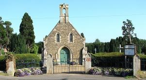
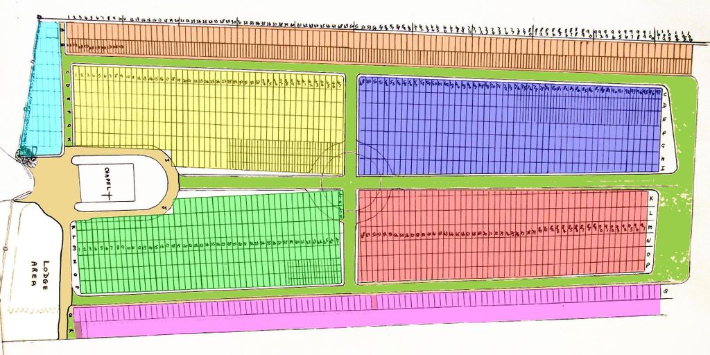
| Memorials | : | 271 |
| Location | : | Towcester, South Northamptonshire Borough, England |
| Coordinate | : | 52.1294010, -0.9997560 |
frequently asked questions (FAQ):
-
Where is Brackley Road Cemetery?
Brackley Road Cemetery is located at Towcester, South Northamptonshire Borough ,Northamptonshire ,England.
-
Brackley Road Cemetery cemetery's updated grave count on graveviews.com?
268 memorials
-
Where are the coordinates of the Brackley Road Cemetery?
Latitude: 52.1294010
Longitude: -0.9997560
Nearby Cemetories:
1. St. Mary's Churchyard
Easton Neston, South Northamptonshire Borough, England
Coordinate: 52.1363720, -0.9756590
2. St Bartholomew Churchyard
Greens Norton, South Northamptonshire Borough, England
Coordinate: 52.1434200, -1.0234100
3. St. John the Baptist Churchyard
Tiffield, South Northamptonshire Borough, England
Coordinate: 52.1586117, -0.9794450
4. St. John the Baptist Churchyard
Abthorpe, South Northamptonshire Borough, England
Coordinate: 52.1131262, -1.0529425
5. St James the Great Churchyard
Paulerspury, South Northamptonshire Borough, England
Coordinate: 52.1032000, -0.9565000
6. St. Botolph's Churchyard
Slapton, South Northamptonshire Borough, England
Coordinate: 52.1166000, -1.0666000
7. St. Luke's Churchyard
Cold Higham, South Northamptonshire Borough, England
Coordinate: 52.1759000, -1.0323000
8. Church of the Holy Cross
Pattishall, South Northamptonshire Borough, England
Coordinate: 52.1828670, -1.0197770
9. St Mary Churchyard
Blakesley, South Northamptonshire Borough, England
Coordinate: 52.1489310, -1.0850410
10. St. Mary's Churchyard
Blakesley, South Northamptonshire Borough, England
Coordinate: 52.1490000, -1.0850000
11. Blisworth
Blisworth, South Northamptonshire Borough, England
Coordinate: 52.1751366, -0.9416729
12. St. Mary the Virgin Churchyard
Wappenham, South Northamptonshire Borough, England
Coordinate: 52.1057700, -1.0890570
13. St. Mary the Virgin Churchyard
Gayton, South Northamptonshire Borough, England
Coordinate: 52.1869000, -0.9687000
14. St Mary's Church
Grafton Regis, South Northamptonshire Borough, England
Coordinate: 52.1154430, -0.8931010
15. Lillingstone Lovell Cemetery
Lillingstone Lovell, Aylesbury Vale District, England
Coordinate: 52.0584600, -0.9619000
16. Parish Church of the Assumption
Lillingstone Lovell, Aylesbury Vale District, England
Coordinate: 52.0582400, -0.9621460
17. St Mary and St Peter Churchyard
Weedon Lois, South Northamptonshire Borough, England
Coordinate: 52.1178320, -1.1228690
18. St Leonards Church
Yardley Gobion, South Northamptonshire Borough, England
Coordinate: 52.0962081, -0.8844584
19. St Peter and St Paul
Rothersthorpe, South Northamptonshire Borough, England
Coordinate: 52.2034651, -0.9566385
20. St. Nicholas of Myra Churchyard
Lillingstone Dayrell, Aylesbury Vale District, England
Coordinate: 52.0524510, -0.9728480
21. Rothersthorpe Extension
Rothersthorpe, South Northamptonshire Borough, England
Coordinate: 52.2046235, -0.9591382
22. St Michael & All Angels Churchyard
Bugbrooke, South Northamptonshire Borough, England
Coordinate: 52.2096900, -1.0149000
23. Courteenhall
Courteenhall, South Northamptonshire Borough, England
Coordinate: 52.1695200, -0.8834900
24. United Reformed Church
Potterspury, South Northamptonshire Borough, England
Coordinate: 52.0836703, -0.8887879