
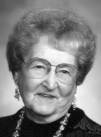

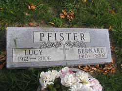
Lucy Anna Jungwirth Pfister
| Birth | : | 9 May 1912 Aberdeen, Brown County, South Dakota, USA |
| Death | : | 12 Oct 2006 Redfield, Spink County, South Dakota, USA |
| Burial | : | St Andrew Churchyard, Slaidburn, Ribble Valley Borough, England |
| Coordinate | : | 53.9641600, -2.4437090 |
| Description | : | A mass of Christian burial for Lucy Anna Pfister, 94, Redfield, was held Thursday, Oct. 5, 2006, at St. Bernard's Catholic Church, Redfield, with Father William Osborn officiating. Burial was in St. Bernard's Cemetery, Redfield. The Thelen Funeral Home, Redfield, was in charge of arrangements. Mrs. Pfister died Sunday, Oct. 1, 2006, at Beverly Healthcare Center, Redfield. She was born May 9, 1912, in Aberdeen, one of six children, to John and Josephine (Leitner) Jungwirth. She attended a rural school through the eighth grade, at which time she left school to help with the family farm and to... Read More |
frequently asked questions (FAQ):
-
Where is Lucy Anna Jungwirth Pfister's memorial?
Lucy Anna Jungwirth Pfister's memorial is located at: St Andrew Churchyard, Slaidburn, Ribble Valley Borough, England.
-
When did Lucy Anna Jungwirth Pfister death?
Lucy Anna Jungwirth Pfister death on 12 Oct 2006 in Redfield, Spink County, South Dakota, USA
-
Where are the coordinates of the Lucy Anna Jungwirth Pfister's memorial?
Latitude: 53.9641600
Longitude: -2.4437090
Family Members:
Parent
Spouse
Flowers:


Nearby Cemetories:
1. St James Churchyard
Tosside, Ribble Valley Borough, England
Coordinate: 53.9940290, -2.4029690
2. St Hubert Roman Catholic Churchyard
Dunsop Bridge, Ribble Valley Borough, England
Coordinate: 53.9460100, -2.5246900
3. Holden Chapel
Bolton-by-Bowland, Ribble Valley Borough, England
Coordinate: 53.9420850, -2.3500060
4. Mount Sion Independent Chapelyard
Tosside, Ribble Valley Borough, England
Coordinate: 53.9982500, -2.3578200
5. St Bartholomew Churchyard
Tosside, Ribble Valley Borough, England
Coordinate: 54.0002500, -2.3536700
6. St. Michael's Churchyard
Whitewell, Ribble Valley Borough, England
Coordinate: 53.9167560, -2.5209540
7. Grindleton Methodist Cemetery
Grindleton, Ribble Valley Borough, England
Coordinate: 53.9080420, -2.3684420
8. St Peter and St Paul Churchyard
Bolton-by-Bowland, Ribble Valley Borough, England
Coordinate: 53.9399800, -2.3270300
9. St Ambrose Churchyard
Grindleton, Ribble Valley Borough, England
Coordinate: 53.9061710, -2.3633270
10. St Helen Churchyard
Waddington, Ribble Valley Borough, England
Coordinate: 53.8898700, -2.4143900
11. Sawley Abbey
Sawley, Ribble Valley Borough, England
Coordinate: 53.9131920, -2.3417080
12. Christ Churchyard
Chatburn, Ribble Valley Borough, England
Coordinate: 53.8940690, -2.3515030
13. Clitheroe Cemetery
Clitheroe, Ribble Valley Borough, England
Coordinate: 53.8779250, -2.3984550
14. St. Joseph's Roman Catholic Cemetery
Clitheroe, Ribble Valley Borough, England
Coordinate: 53.8770700, -2.3960000
15. St Mary Magdalene Churchyard
Clitheroe, Ribble Valley Borough, England
Coordinate: 53.8740980, -2.3903420
16. St. Leonard's Churchyard
Downham, Ribble Valley Borough, England
Coordinate: 53.8944340, -2.3294250
17. Trinity Methodist Churchyard
Clitheroe, Ribble Valley Borough, England
Coordinate: 53.8709060, -2.3954550
18. St James Churchyard
Clitheroe, Ribble Valley Borough, England
Coordinate: 53.8659600, -2.3922700
19. Brocklands Woodland Burial Site
Rathmell, Craven District, England
Coordinate: 54.0275720, -2.2998880
20. Holy Trinity Churchyard
Rathmell, Craven District, England
Coordinate: 54.0351000, -2.3002300
21. St. Bartholomew Churchyard
Chipping, Ribble Valley Borough, England
Coordinate: 53.8846800, -2.5764100
22. St. Mary the Virgin Churchyard
Gisburn, Ribble Valley Borough, England
Coordinate: 53.9356080, -2.2605210
23. Chipping Congregational Churchyard
Chipping, Ribble Valley Borough, England
Coordinate: 53.8836000, -2.5777700
24. Salem Congregational Chapel Martin Top
Rimington, Ribble Valley Borough, England
Coordinate: 53.9072484, -2.2740463