
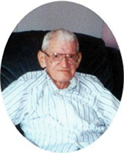
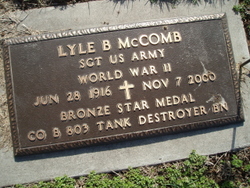
Lyle Bert McComb
| Birth | : | 28 Jun 1916 Saint Edward, Boone County, Nebraska, USA |
| Death | : | 7 Nov 2000 Saint Edward, Boone County, Nebraska, USA |
| Burial | : | St. Mary the Virgin Churchyard, Gisburn, Ribble Valley Borough, England |
| Coordinate | : | 53.9356080, -2.2605210 |
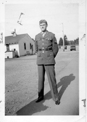
| Description | : | Son of Frank & Nannie (Condreay) McComb. He graduated from St. Edward High School in 1934. He served in the Army during World War II from April 10, 1941 to October 7, 1945. He was a tank commander with the 803rd Tank Destroyer Battalion and served in the European Theater. Lyle married Leona Christensen on October 30, 1946 in Washington, Kansas, they moved to Columbus from St. Edward in 1952. He was a truck driver for Werner Trucking in St. Edward and then later for Behlen Manufacturing in Columbus. He worked for Person's Sport Shop for a short time, then... Read More |
frequently asked questions (FAQ):
-
Where is Lyle Bert McComb's memorial?
Lyle Bert McComb's memorial is located at: St. Mary the Virgin Churchyard, Gisburn, Ribble Valley Borough, England.
-
When did Lyle Bert McComb death?
Lyle Bert McComb death on 7 Nov 2000 in Saint Edward, Boone County, Nebraska, USA
-
Where are the coordinates of the Lyle Bert McComb's memorial?
Latitude: 53.9356080
Longitude: -2.2605210
Family Members:
Parent

Spouse
Siblings
Flowers:


Nearby Cemetories:
1. St. Mary the Virgin Churchyard
Gisburn, Ribble Valley Borough, England
Coordinate: 53.9356080, -2.2605210
2. Salem Congregational Chapel Martin Top
Rimington, Ribble Valley Borough, England
Coordinate: 53.9072484, -2.2740463
3. Saint Michael's Church
Bracewell, Pendle Borough, England
Coordinate: 53.9322400, -2.2099730
4. St Peter and St Paul Churchyard
Bolton-by-Bowland, Ribble Valley Borough, England
Coordinate: 53.9399800, -2.3270300
5. Twiston Quaker Burial Ground
Clitheroe, Ribble Valley Borough, England
Coordinate: 53.8854210, -2.2838840
6. Sawley Abbey
Sawley, Ribble Valley Borough, England
Coordinate: 53.9131920, -2.3417080
7. Holden Chapel
Bolton-by-Bowland, Ribble Valley Borough, England
Coordinate: 53.9420850, -2.3500060
8. Saint Mary-le-Ghyll
Barnoldswick, Pendle Borough, England
Coordinate: 53.9279505, -2.1647004
9. Ghyll Cemetery
Barnoldswick, Pendle Borough, England
Coordinate: 53.9271100, -2.1646700
10. St. Leonard's Churchyard
Downham, Ribble Valley Borough, England
Coordinate: 53.8944340, -2.3294250
11. Salterforth Cemetery
Salterforth, Pendle Borough, England
Coordinate: 53.9123170, -2.1654010
12. St Mary the Virgin Churchyard
Thornton-in-Craven, Craven District, England
Coordinate: 53.9311350, -2.1513350
13. St Ambrose Churchyard
Grindleton, Ribble Valley Borough, England
Coordinate: 53.9061710, -2.3633270
14. Christ Churchyard
Chatburn, Ribble Valley Borough, England
Coordinate: 53.8940690, -2.3515030
15. Grindleton Methodist Cemetery
Grindleton, Ribble Valley Borough, England
Coordinate: 53.9080420, -2.3684420
16. St Peter Church
Martons Both, Craven District, England
Coordinate: 53.9522630, -2.1415720
17. St. Peter's Churchyard
Martons Both, Craven District, England
Coordinate: 53.9522064, -2.1413111
18. St. Aidan's Churchyard
Hellifield, Craven District, England
Coordinate: 54.0042070, -2.2201370
19. Earby Cemetery
Earby, Pendle Borough, England
Coordinate: 53.9189987, -2.1370001
20. St Mary's Churchyard
Kelbrook, Pendle Borough, England
Coordinate: 53.8991000, -2.1494100
21. Friends Burial Ground
Foulridge, Pendle Borough, England
Coordinate: 53.8769360, -2.1669040
22. St. Michael's Churchyard
Foulridge, Pendle Borough, England
Coordinate: 53.8734569, -2.1693508
23. St Mary the Virgin Churchyard
Long Preston, Craven District, England
Coordinate: 54.0183790, -2.2497690
24. St Bartholomew Churchyard
Tosside, Ribble Valley Borough, England
Coordinate: 54.0002500, -2.3536700