
| Birth | : | 9 Jul 1891 |
| Death | : | 11 Apr 1946 Clinton, Vermillion County, Indiana, USA |
| Burial | : | St. Mary the Virgin Churchyard, Bottesford, Melton Borough, England |
| Coordinate | : | 52.9434270, -0.8001460 |
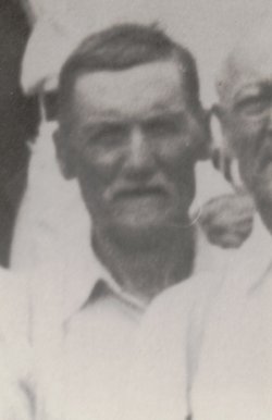
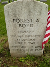
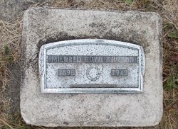
| Description | : | She married Harry Homer Frist February 19, 1911. They were the parents of Emily, Esther, Shirley, Myrtle and Patricia. Per Carolyn Schwab: She was a daughter of Albert E. Boyd and Emily C. Skidmore. From Frist Funeral Home Records. The following is courtesy of Harrison Pierce: April 11, 1946 Mrs. Mabel Frist, County Resident Dies at Hospital Mrs. Mabel Frist, 54, Route 1, Clinton, died at the Vermillion County hospital at 5:45 this morning following a brief illness. Mrs. Frist was a life-time resident of Vermillion County and a member of the Salem Methodist Church, north of Clinton. She is survived by the husband, Harry; five... Read More |
frequently asked questions (FAQ):
-
Where is Mable Audrey Boyd Frist's memorial?
Mable Audrey Boyd Frist's memorial is located at: St. Mary the Virgin Churchyard, Bottesford, Melton Borough, England.
-
When did Mable Audrey Boyd Frist death?
Mable Audrey Boyd Frist death on 11 Apr 1946 in Clinton, Vermillion County, Indiana, USA
-
Where are the coordinates of the Mable Audrey Boyd Frist's memorial?
Latitude: 52.9434270
Longitude: -0.8001460
Family Members:
Parent

Spouse
Siblings
Children
Flowers:


Nearby Cemetories:
1. St. Mary the Virgin Churchyard
Bottesford, Melton Borough, England
Coordinate: 52.9434270, -0.8001460
2. St John the Baptist Churchyard
Muston, Melton Borough, England
Coordinate: 52.9315700, -0.7680600
3. St Peter Churchyard
Redmile, Melton Borough, England
Coordinate: 52.9113200, -0.8161530
4. St Mary's Churchyard
Kilvington, Newark and Sherwood District, England
Coordinate: 52.9772500, -0.8092250
5. St Mary's Churchyard
Orston, Rushcliffe Borough, England
Coordinate: 52.9622500, -0.8560300
6. St Peter's Churchyard
Flawborough, Rushcliffe Borough, England
Coordinate: 52.9773700, -0.8365800
7. Barkestone le Vale St Peter & St Paul
Barkestone, Melton Borough, England
Coordinate: 52.9062600, -0.8450200
8. St. Lawrence Churchyard
Sedgebrook, South Kesteven District, England
Coordinate: 52.9329460, -0.7256530
9. Belvoir Priory
Bottesford, Melton Borough, England
Coordinate: 52.8982090, -0.7825130
10. St James Churchyard
Allington, South Kesteven District, England
Coordinate: 52.9525695, -0.7245301
11. Belvoir Castle
Belvoir, Melton Borough, England
Coordinate: 52.8911170, -0.7855620
12. St Swithun Churchyard
Long Bennington, South Kesteven District, England
Coordinate: 52.9856290, -0.7449190
13. St James Churchyard
Woolsthorpe-by-Belvoir, South Kesteven District, England
Coordinate: 52.8957880, -0.7578370
14. St Mary & All Saints Churchyard
Shelton, Rushcliffe Borough, England
Coordinate: 52.9932200, -0.8389300
15. St. John of Beverley Churchyard
Whatton, Rushcliffe Borough, England
Coordinate: 52.9493000, -0.8926000
16. St. Helen's Churchyard
Plungar, Melton Borough, England
Coordinate: 52.8986260, -0.8569390
17. All Saints Churchyard
Granby, Rushcliffe Borough, England
Coordinate: 52.9180770, -0.8847700
18. St Peter Churchyard
Foston, South Kesteven District, England
Coordinate: 52.9771630, -0.7227360
19. All Saints Churchyard
Westborough, South Kesteven District, England
Coordinate: 52.9892900, -0.7350100
20. St Mary & All Saints Churchyard
Hawksworth, Rushcliffe Borough, England
Coordinate: 52.9831700, -0.8800500
21. All Saints Churchyard
Barrowby, South Kesteven District, England
Coordinate: 52.9186420, -0.6946810
22. St John of Beverley Churchyard
Scarrington, Rushcliffe Borough, England
Coordinate: 52.9667400, -0.9071900
23. St Michael & All Angels Churchyard
Harston, Melton Borough, England
Coordinate: 52.8769700, -0.7556000
24. All Saints Churchyard
Knipton, South Kesteven District, England
Coordinate: 52.8711300, -0.7769400