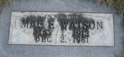
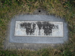
Mae Evelyn Paulsen Watson
| Birth | : | 1 May 1912 Montana, USA |
| Death | : | 2 Dec 1981 Libby, Lincoln County, Montana, USA |
| Burial | : | Short Creek Methodist Church Cemetery, West Liberty, Ohio County, USA |
| Coordinate | : | 40.1568985, -80.6389008 |
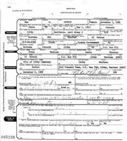
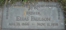
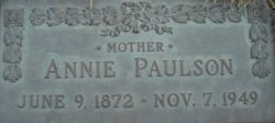
| Description | : | Montana, County Births and Deaths Name: Mae E. Watson [Mae E. Paulson] Gender: Female Death Age: 69 Birth Date: 1 May 1912 Birth Place: Montana, USA Death Date: 2 Dec 1981 Death Place: Libby, Lincoln, Montana Father: Elias Paulson Mother: Annie Paulson Spouse: AL Watson Evangelical Lutheran Church of America, Records, 1875-1940 Name: May Evelyn Paulsen Event Type: Confirmation Birth Date: 1 May 1912 Confirmation Date: 24 Apr 1927 Father: Elias Mother: Anna Church Name: First Lutheran Church Location: Libby, Montana Montana, Death Index, 1868-2011 Name: Mae E Watson Birth Year: abt 1912 Death Date: 2 Dec 1981 Death County: Lincoln Age at... Read More |
frequently asked questions (FAQ):
-
Where is Mae Evelyn Paulsen Watson's memorial?
Mae Evelyn Paulsen Watson's memorial is located at: Short Creek Methodist Church Cemetery, West Liberty, Ohio County, USA.
-
When did Mae Evelyn Paulsen Watson death?
Mae Evelyn Paulsen Watson death on 2 Dec 1981 in Libby, Lincoln County, Montana, USA
-
Where are the coordinates of the Mae Evelyn Paulsen Watson's memorial?
Latitude: 40.1568985
Longitude: -80.6389008
Family Members:
Parent
Siblings
Children
Nearby Cemetories:
1. Short Creek Methodist Church Cemetery
West Liberty, Ohio County, USA
Coordinate: 40.1568985, -80.6389008
2. Morgan Cemetery
West Liberty, Ohio County, USA
Coordinate: 40.1469002, -80.6042023
3. Prall Cemetery
West Liberty, Ohio County, USA
Coordinate: 40.1675040, -80.5992960
4. Wilson Cemetery
Clearview, Ohio County, USA
Coordinate: 40.1608009, -80.6813965
5. Lawrencefield Parish Church Cemetery
Ohio County, USA
Coordinate: 40.1281310, -80.6615600
6. West Liberty Cemetery
West Liberty, Ohio County, USA
Coordinate: 40.1674995, -80.5939026
7. Oaklawn Memorial Park
Clearview, Ohio County, USA
Coordinate: 40.1469002, -80.6931000
8. Riley Hill Road Cemetery
Clearview, Ohio County, USA
Coordinate: 40.1456299, -80.6941910
9. Mound Cemetery
Tiltonsville, Jefferson County, USA
Coordinate: 40.1744003, -80.6949997
10. Cox Cemetery
West Liberty, Ohio County, USA
Coordinate: 40.1707993, -80.5802994
11. Old Tent Cemetery
Wheeling, Ohio County, USA
Coordinate: 40.1090164, -80.6372910
12. Dement Cemetery
West Liberty, Ohio County, USA
Coordinate: 40.1244380, -80.5911110
13. Kadesh Chapel Cemetery
Beech Bottom, Brooke County, USA
Coordinate: 40.2053000, -80.6293700
14. Warrenton Cemetery
Rayland, Jefferson County, USA
Coordinate: 40.1937700, -80.6838900
15. Clendenen Cemetery
Beech Bottom, Brooke County, USA
Coordinate: 40.2100870, -80.6591180
16. King Family Cemetery
Rayland, Jefferson County, USA
Coordinate: 40.1689423, -80.7109297
17. Faris Family Cemetery
Ohio County, USA
Coordinate: 40.1201000, -80.5727800
18. Wells Cemetery
Beech Bottom, Brooke County, USA
Coordinate: 40.2221985, -80.6322021
19. Parkview Memorial Gardens
Wheeling, Ohio County, USA
Coordinate: 40.0917015, -80.6560974
20. Roneys Point Cemetery
Wheeling, Ohio County, USA
Coordinate: 40.0932530, -80.6105200
21. Cochran Family Cemetery
Martins Ferry, Belmont County, USA
Coordinate: 40.1361110, -80.7230570
22. Upland Heights Cemetery
Warren Township, Jefferson County, USA
Coordinate: 40.1608009, -80.7285995
23. Henschel Cemetery
Pease Township, Belmont County, USA
Coordinate: 40.1197200, -80.7177840
24. Nixon Farm Cemetery
Martins Ferry, Belmont County, USA
Coordinate: 40.1325000, -80.7277780


