
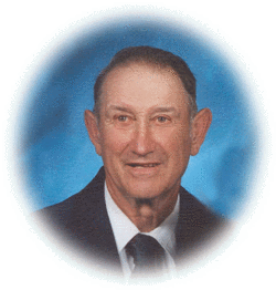
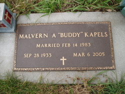
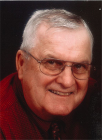
Malvern A. “Buddy” Kapels
| Birth | : | 28 Sep 1933 Creston, Platte County, Nebraska, USA |
| Death | : | 5 Mar 2005 Omaha, Douglas County, Nebraska, USA |
| Burial | : | St Bartholomews Parish Churchyard, Quorn, Charnwood Borough, England |
| Coordinate | : | 52.7440274, -1.1703330 |
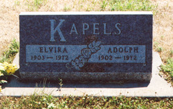
| Description | : | Son of Adolph & Elvira (Osten) Kapels. He attended rural Platte County and St. John's Lutheran grade schools. He graduated from Creston High School. After graduation, Malvern farmed with his father. For one year, Malvern went to California where he worked in an Aircraft Bomber Plant. He returned to Nebraska and joined his brothers and father in El Crest Dairy Farms, where he took care of the cattle feeding. Malvern married Rose Ellen (Marx) Kapels on February 14, 1983 at St. John's Lutheran Church. Malvern was a long time member of St. John's Lutheran Church (LCMS) where... Read More |
frequently asked questions (FAQ):
-
Where is Malvern A. “Buddy” Kapels's memorial?
Malvern A. “Buddy” Kapels's memorial is located at: St Bartholomews Parish Churchyard, Quorn, Charnwood Borough, England.
-
When did Malvern A. “Buddy” Kapels death?
Malvern A. “Buddy” Kapels death on 5 Mar 2005 in Omaha, Douglas County, Nebraska, USA
-
Where are the coordinates of the Malvern A. “Buddy” Kapels's memorial?
Latitude: 52.7440274
Longitude: -1.1703330
Family Members:
Parent

Spouse
Siblings
Flowers:


Nearby Cemetories:
1. St Bartholomews Parish Churchyard
Quorn, Charnwood Borough, England
Coordinate: 52.7440274, -1.1703330
2. Quorn Baptist Churchyard
Quorn, Charnwood Borough, England
Coordinate: 52.7407600, -1.1753200
3. Mountsorrel Cemetery
Mountsorrel, Charnwood Borough, England
Coordinate: 52.7378380, -1.1547880
4. Holy Trinity Churchyard
Barrow-upon-Soar, Charnwood Borough, England
Coordinate: 52.7526930, -1.1470900
5. Barrow-Upon-Soar Cemetery
Barrow-upon-Soar, Charnwood Borough, England
Coordinate: 52.7620220, -1.1585640
6. Loughborough Crematorium
Loughborough, Charnwood Borough, England
Coordinate: 52.7575650, -1.1965200
7. Loughborough Cemetery
Loughborough, Charnwood Borough, England
Coordinate: 52.7599400, -1.1951700
8. St. Peter's Churchyard
Mountsorrel, Charnwood Borough, England
Coordinate: 52.7304450, -1.1408620
9. St. Mary in the Elms Churchyard
Woodhouse, Charnwood Borough, England
Coordinate: 52.7313280, -1.2039850
10. Christchurch Churchyard
Mountsorrel, Charnwood Borough, England
Coordinate: 52.7268480, -1.1409340
11. Emmanuel Churchyard
Loughborough, Charnwood Borough, England
Coordinate: 52.7668830, -1.2108020
12. St. Leonard's Churchyard
Swithland, Charnwood Borough, England
Coordinate: 52.7103000, -1.1800300
13. Rothley Cemetery
Rothley, Charnwood Borough, England
Coordinate: 52.7162850, -1.1367740
14. St. Paul's Churchyard
Woodhouse, Charnwood Borough, England
Coordinate: 52.7216880, -1.2139190
15. Prestwold Natural Burial Ground
Loughborough, Charnwood Borough, England
Coordinate: 52.7779510, -1.1538520
16. All Saints with Holy Trinity Churchyard
Loughborough, Charnwood Borough, England
Coordinate: 52.7743880, -1.2035500
17. St. Mary's Churchyard
Sileby, Charnwood Borough, England
Coordinate: 52.7308600, -1.1121420
18. St Mary Churchyard
Walton-on-the-Wolds, Charnwood Borough, England
Coordinate: 52.7712900, -1.1241310
19. Chapel of the Knights Templar
Rothley, Charnwood Borough, England
Coordinate: 52.7056000, -1.1478000
20. St. Mary and St. John Churchyard
Rothley, Charnwood Borough, England
Coordinate: 52.7083290, -1.1340270
21. Sileby Cemetery
Sileby, Charnwood Borough, England
Coordinate: 52.7299340, -1.1004210
22. St. Andrew's Churchyard
Prestwold, Charnwood Borough, England
Coordinate: 52.7875000, -1.1446400
23. All Saints Churchyard
Cossington, Charnwood Borough, England
Coordinate: 52.7173590, -1.1073300
24. Seagrave Swan Street Cemetery
Seagrave, Charnwood Borough, England
Coordinate: 52.7520370, -1.0883200