
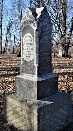

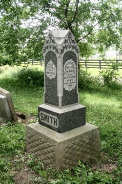
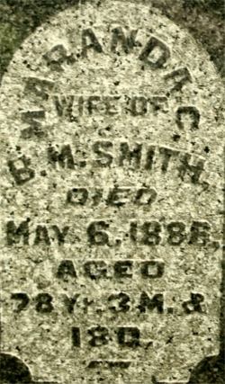

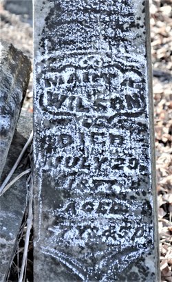
Maranda C. Smith Smith
| Birth | : | 18 Jan 1808 South Carolina, USA |
| Death | : | 6 May 1886 Jolietville, Hamilton County, Indiana, USA |
| Burial | : | Horn Creek Baptist Church Cemetery, Gilmer County, USA |
| Coordinate | : | 39.0605700, -80.8633500 |
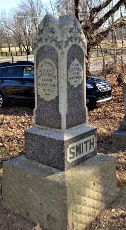
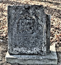
| Inscription | : | Our Father And Mother ===== SMITH Maranda C. Wife Of B. M. Smith Died May 6, 1886, Aged 78 Yr. 3 M. & 18 D. Also on this monument: B. M. Smith (d.1864) |
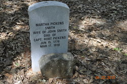
| Description | : | Daughter of John & Martha (Pickens) Smith of South Carolina |
frequently asked questions (FAQ):
-
Where is Maranda C. Smith Smith's memorial?
Maranda C. Smith Smith's memorial is located at: Horn Creek Baptist Church Cemetery, Gilmer County, USA.
-
When did Maranda C. Smith Smith death?
Maranda C. Smith Smith death on 6 May 1886 in Jolietville, Hamilton County, Indiana, USA
-
Where are the coordinates of the Maranda C. Smith Smith's memorial?
Latitude: 39.0605700
Longitude: -80.8633500
Family Members:
Parent
Spouse
Siblings
Children


Nearby Cemetories:
1. Fisher Cemetery
Troy, Gilmer County, USA
Coordinate: 39.0480500, -80.8400000
2. Newberne Cemetery
Gilmer County, USA
Coordinate: 39.0465510, -80.8910940
3. Hall Cemetery
Gilmer County, USA
Coordinate: 39.0816994, -80.8383026
4. Auburn Baptist Church Cemetery
Auburn, Ritchie County, USA
Coordinate: 39.0819200, -80.8384600
5. Auburn Community Cemetery
Auburn, Ritchie County, USA
Coordinate: 39.0960999, -80.8533020
6. Spruce Creek Cemetery
Auburn, Ritchie County, USA
Coordinate: 39.0807300, -80.9083700
7. Bush Cemetery
Gilmer County, USA
Coordinate: 39.0203018, -80.8783035
8. Union Baptist Church Cemetery
Lucerne, Gilmer County, USA
Coordinate: 39.0200800, -80.8779200
9. Abraham Bush Cemetery
Lucerne, Gilmer County, USA
Coordinate: 39.0184000, -80.8856806
10. Mount Olive Cemetery
Burnt House, Ritchie County, USA
Coordinate: 39.0531006, -80.9257965
11. Matthews Cemetery
Lucerne, Gilmer County, USA
Coordinate: 39.0112200, -80.8839100
12. New Mount Olive Cemetery
Burnt House, Ritchie County, USA
Coordinate: 39.0446100, -80.9340200
13. Keister Cemetery
Gilmer County, USA
Coordinate: 39.0727997, -80.7817001
14. Cooper Chapel Cemetery
Tanner, Gilmer County, USA
Coordinate: 39.0057800, -80.9161500
15. Mount Union Methodist Cemetery
Leopold, Doddridge County, USA
Coordinate: 39.1133330, -80.8050000
16. Cooper Family Cemetery
Tanner, Gilmer County, USA
Coordinate: 39.0083050, -80.9255920
17. Leading Creek Baptist Church Cemetery
Alice, Gilmer County, USA
Coordinate: 38.9969000, -80.8183700
18. Spurgeon Cemetery
Conings, Gilmer County, USA
Coordinate: 39.1019000, -80.7801750
19. Mount Earnest Cemetery
Gilmer County, USA
Coordinate: 39.0867004, -80.7652969
20. Troy IOOF Community Cemetery
Troy, Gilmer County, USA
Coordinate: 39.0281170, -80.7679560
21. Woodford Farm Cemetery
Lucerne, Gilmer County, USA
Coordinate: 38.9819600, -80.8880900
22. Brannon Cemetery
Gilmer County, USA
Coordinate: 39.0997009, -80.7718964
23. Roseville Church Cemetery
Gilmer County, USA
Coordinate: 39.0207880, -80.9547600
24. Pine Low Gap Cemetery
Burnt House, Ritchie County, USA
Coordinate: 39.1006400, -80.9562200