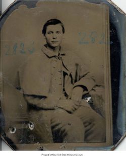
| Birth | : | 10 Jan 1860 Massena, St. Lawrence County, New York, USA |
| Death | : | 17 Sep 1951 Bellingham, Whatcom County, Washington, USA |
| Burial | : | St Paul Churchyard, Stalybridge, Metropolitan Borough of Tameside, England |
| Coordinate | : | 53.4852000, -2.0440300 |
| Plot | : | 11 |
| Description | : | When Marcus Lewis Bangle was born on January 10, 1860, in Massena, New York, his father, Joseph, was 49 and his mother, Mary, was 44. He married Minnie Isobel Lathrop in 1884 in De Smet, South Dakota. They had five children in 16 years. He died on September 17, 1951, in Bellingham, Washington, at the age of 91. Baptism Records from St. Regis Indian Mission indicate that Marcus and his siblings were 1/4 Mohawk Native. Their grandmother, Angelique "Nellie" Duhault dit Jasmin resided at the St Regis Indian Reservation, St. Regis, NY. |
frequently asked questions (FAQ):
-
Where is Marcus Lewis Bangle's memorial?
Marcus Lewis Bangle's memorial is located at: St Paul Churchyard, Stalybridge, Metropolitan Borough of Tameside, England.
-
When did Marcus Lewis Bangle death?
Marcus Lewis Bangle death on 17 Sep 1951 in Bellingham, Whatcom County, Washington, USA
-
Where are the coordinates of the Marcus Lewis Bangle's memorial?
Latitude: 53.4852000
Longitude: -2.0440300
Family Members:
Parent
Spouse
Siblings
Children
Flowers:
Nearby Cemetories:
1. St Paul Churchyard
Stalybridge, Metropolitan Borough of Tameside, England
Coordinate: 53.4852000, -2.0440300
2. St George's Old Churchyard
Stalybridge, Metropolitan Borough of Tameside, England
Coordinate: 53.4844700, -2.0538800
3. St Georges Cemetery
Stalybridge, Metropolitan Borough of Tameside, England
Coordinate: 53.4873400, -2.0576800
4. Bethel Chapel Chapelyard
Stalybridge, Metropolitan Borough of Tameside, England
Coordinate: 53.4820413, -2.0576195
5. St John's Churchyard
Dukinfield, Metropolitan Borough of Tameside, England
Coordinate: 53.4771000, -2.0726000
6. St Mary's Churchyard
Hyde, Metropolitan Borough of Tameside, England
Coordinate: 53.4652400, -2.0599700
7. Hurst Cemetery
Ashton-Under-Lyne, Metropolitan Borough of Tameside, England
Coordinate: 53.5011590, -2.0727370
8. Mossley Cemetery
Mossley, Metropolitan Borough of Tameside, England
Coordinate: 53.5092100, -2.0332700
9. Dukinfield Cemetery and Crematorium
Dukinfield, Metropolitan Borough of Tameside, England
Coordinate: 53.4800300, -2.0857150
10. St. John the Evangelist Churchyard
Hurst, Metropolitan Borough of Tameside, England
Coordinate: 53.5001310, -2.0812490
11. St. George Parish Churchyard
Mossley, Metropolitan Borough of Tameside, England
Coordinate: 53.5164000, -2.0486200
12. St. John The Baptist Churchyard
Hyde, Metropolitan Borough of Tameside, England
Coordinate: 53.4548411, -2.0644712
13. Hollingworth United Methodist Cemetery
Hollingworth, Metropolitan Borough of Tameside, England
Coordinate: 53.4632891, -1.9958244
14. St. Peter's Churchyard
Ashton-Under-Lyne, Metropolitan Borough of Tameside, England
Coordinate: 53.4839340, -2.1054690
15. St. Michael Churchyard
Mottram in Longdendale, Metropolitan Borough of Tameside, England
Coordinate: 53.4544040, -2.0101460
16. Mottram Cemetery
Mottram in Longdendale, Metropolitan Borough of Tameside, England
Coordinate: 53.4546420, -2.0086900
17. Saint Thomas The Apostle Churchyard
Hyde, Metropolitan Borough of Tameside, England
Coordinate: 53.4509000, -2.0707000
18. Saint Stephens Churchyard
Audenshaw, Metropolitan Borough of Tameside, England
Coordinate: 53.4753000, -2.1151700
19. St George Churchyard
Hyde, Metropolitan Borough of Tameside, England
Coordinate: 53.4466540, -2.0789750
20. Hyde Cemetery
Hyde, Metropolitan Borough of Tameside, England
Coordinate: 53.4437910, -2.0684130
21. Audenshaw Cemetery
Audenshaw, Metropolitan Borough of Tameside, England
Coordinate: 53.4653300, -2.1101560
22. Tintwistle Churchyard
Tintwistle, High Peak Borough, England
Coordinate: 53.4719150, -1.9685915
23. Holy Trinity Churchyard
Gee Cross, Metropolitan Borough of Tameside, England
Coordinate: 53.4393900, -2.0645500
24. United Reformed Church
Tintwistle, High Peak Borough, England
Coordinate: 53.4729900, -1.9657910


