
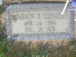
Marion B “Molly” Rideout Diemert
| Birth | : | 26 Apr 1894 Dedham, Hancock County, Maine, USA |
| Death | : | 28 Dec 1979 Chester, Liberty County, Montana, USA |
| Burial | : | Rudyard Cemetery, Rudyard, Hill County, USA |
| Coordinate | : | 48.5659500, -110.5390000 |
| Description | : | Liberty County Times, Chester, MT, 3 Jan 1980 Marion Bernice ("Molly") was born on April 26, 1894, in Dedham, Maine. She was one of 12 children born to Edwin and Ida May (Webber) Rideout. She attended schools in the Ellsworth, Maine area and graduated from high school in 1912. She obtained a teaching certificate and taught school in Maine before coming to Montana in 1915. At that time Marion taught in an elementary country school near Conrad. On Sept. 9, 1918, she married August L. Diemert, who had homesteaded south of Rudyard. He farmed and she taught in the... Read More |
frequently asked questions (FAQ):
-
Where is Marion B “Molly” Rideout Diemert's memorial?
Marion B “Molly” Rideout Diemert's memorial is located at: Rudyard Cemetery, Rudyard, Hill County, USA.
-
When did Marion B “Molly” Rideout Diemert death?
Marion B “Molly” Rideout Diemert death on 28 Dec 1979 in Chester, Liberty County, Montana, USA
-
Where are the coordinates of the Marion B “Molly” Rideout Diemert's memorial?
Latitude: 48.5659500
Longitude: -110.5390000
Family Members:
Spouse
Children

Flowers:


Nearby Cemetories:
1. Rudyard Cemetery
Rudyard, Hill County, USA
Coordinate: 48.5659500, -110.5390000
2. Hingham Union Cemetery
Hingham, Hill County, USA
Coordinate: 48.5601570, -110.4178980
3. Inverness Cemetery
Hill County, USA
Coordinate: 48.5531340, -110.6688450
4. Bethel Cemetery
Hill County, USA
Coordinate: 48.6685982, -110.6406021
5. Joplin Cemetery
Joplin, Liberty County, USA
Coordinate: 48.5576720, -110.7622930
6. Gildford Hill County Cemetery
Gildford, Hill County, USA
Coordinate: 48.5778008, -110.2957993
7. Cool Spring Colony Cemetery
Rudyard, Hill County, USA
Coordinate: 48.7704000, -110.5860000
8. Milk River Valley Church Graveyard
Hill County, USA
Coordinate: 48.6787180, -110.2261080
9. Cottonwood Lutheran Church Cemetery
Havre, Hill County, USA
Coordinate: 48.4545000, -110.1748000
10. Grace Church Cemetery
Rudyard, Hill County, USA
Coordinate: 48.8269930, -110.6209890
11. Chester Cemetery
Chester, Liberty County, USA
Coordinate: 48.5219002, -110.9807968
12. Saint Wenceslaus Cemetery
Goldstone, Hill County, USA
Coordinate: 48.9002610, -110.5310160
13. Kenilworth Cemetery
Chouteau County, USA
Coordinate: 48.2192001, -110.4188995
14. Erickson Cemetery
Liberty County, USA
Coordinate: 48.3143997, -110.9503021
15. Spring Coulee Cemetery
Hill County, USA
Coordinate: 48.9138985, -110.2035980
16. Box Elder Cemetery
Box Elder, Hill County, USA
Coordinate: 48.3274000, -110.0095000
17. Saint Johns Catholic Cemetery
Havre, Hill County, USA
Coordinate: 48.7625008, -109.9638977
18. Eagle Creek Colony Cemetery
Chester, Liberty County, USA
Coordinate: 48.6976000, -111.2011000
19. Grainbelt Cemetery
Hill County, USA
Coordinate: 48.6828003, -109.8657990
20. Sage Creek Colony Cemetery
Sage Creek Colony, Liberty County, USA
Coordinate: 48.9271000, -110.9735000
21. Lothair Protestant Cemetery
Lothair, Liberty County, USA
Coordinate: 48.4694000, -111.2393100
22. Big Sandy Cemetery
Big Sandy, Chouteau County, USA
Coordinate: 48.1801170, -110.1207500
23. Lothair Catholic Cemetery
Lothair, Liberty County, USA
Coordinate: 48.4687000, -111.2484000
24. Trinity Church Cemetery
Lothair, Liberty County, USA
Coordinate: 48.7263000, -111.2296000