
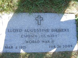
Lloyd Augustine Diemert
| Birth | : | 4 Mar 1921 Kenilworth, Chouteau County, Montana, USA |
| Death | : | 26 Feb 2009 Big Sandy, Chouteau County, Montana, USA |
| Burial | : | Milborne Port Churchyard, Milborne Port, South Somerset District, England |
| Coordinate | : | 50.9653900, -2.4621550 |
| Description | : | Liberty County Times, Chester, MT, 4 Mar 2009 Lloyd Augustine Diemert was born March 4, 1921 in the Kenilworth community west of Big Sandy, Montana. He was one of five children born to Marion "Molly" Rideout and August Diemert. Lloyd grew up on the family farm at Kenilworth and received his education at the Black Coulee country school. Following his school years, Lloyd worked with his father before taking a job with the CCC's. In 1942 Lloyd enlisted in the U. S. Navy. He served in the European-African-Middle Eastern and the Asiatic-Pacific Campaigns during World War II. He attained the rank... Read More |
frequently asked questions (FAQ):
-
Where is Lloyd Augustine Diemert's memorial?
Lloyd Augustine Diemert's memorial is located at: Milborne Port Churchyard, Milborne Port, South Somerset District, England.
-
When did Lloyd Augustine Diemert death?
Lloyd Augustine Diemert death on 26 Feb 2009 in Big Sandy, Chouteau County, Montana, USA
-
Where are the coordinates of the Lloyd Augustine Diemert's memorial?
Latitude: 50.9653900
Longitude: -2.4621550
Family Members:
Parent
Spouse

Siblings


Nearby Cemetories:
1. Milborne Port Churchyard
Milborne Port, South Somerset District, England
Coordinate: 50.9653900, -2.4621550
2. Milborne Port Cemetery
Milborne Port, South Somerset District, England
Coordinate: 50.9662940, -2.4605880
3. St. Peter's Churchyard
Goathill, West Dorset District, England
Coordinate: 50.9534230, -2.4628960
4. St. Peter's Churchyard
Purse Caundle, West Dorset District, England
Coordinate: 50.9569440, -2.4342330
5. St Cuthbert Churchyard
Oborne, West Dorset District, England
Coordinate: 50.9649280, -2.4941270
6. Purse Caundle Civic Cemetery
Purse Caundle, West Dorset District, England
Coordinate: 50.9553680, -2.4327770
7. St. Cuthbert's Old Church
Oborne, West Dorset District, England
Coordinate: 50.9588620, -2.4947350
8. St. Catherine's Churchyard
Haydon, West Dorset District, England
Coordinate: 50.9404290, -2.4702910
9. All Saints Churchyard
Poyntington, West Dorset District, England
Coordinate: 50.9782070, -2.4997530
10. St Mary Magdalene Churchyard
Castleton, West Dorset District, England
Coordinate: 50.9496210, -2.5050130
11. Union Chapel
Sherborne, West Dorset District, England
Coordinate: 50.9475310, -2.5136220
12. Sherborne Abbey
Sherborne, West Dorset District, England
Coordinate: 50.9466680, -2.5166680
13. St. Mary Magdalene Churchyard
North Wootton, West Dorset District, England
Coordinate: 50.9281260, -2.4895320
14. Saint Peter & Saint Paul Churchyard
Charlton Horethorne, South Somerset District, England
Coordinate: 51.0060200, -2.4790100
15. St Nicholas Churchyard
Henstridge, South Somerset District, England
Coordinate: 50.9762610, -2.3957980
16. St. Peter's Churchyard
Stourton Caundle, North Dorset District, England
Coordinate: 50.9354210, -2.4080470
17. Stourton Caundle Civic Cemetery
Stourton Caundle, North Dorset District, England
Coordinate: 50.9349030, -2.4065510
18. Sherborne Cemetery
Sherborne, West Dorset District, England
Coordinate: 50.9420010, -2.5266500
19. St. Peter and St. Paul's Churchyard
Caundle Marsh, West Dorset District, England
Coordinate: 50.9176840, -2.4596680
20. St Lawrence Churchyard
Folke, West Dorset District, England
Coordinate: 50.9179430, -2.4854020
21. St Mary Churchyard
Stalbridge, North Dorset District, England
Coordinate: 50.9623690, -2.3808740
22. Corton Denham Cemetery
Corton Denham, South Somerset District, England
Coordinate: 51.0015810, -2.5202380
23. Saint Andrew Churchyard
Corton Denham, South Somerset District, England
Coordinate: 51.0015790, -2.5203100
24. Bishops Caundle
Bishops Caundle, West Dorset District, England
Coordinate: 50.9171310, -2.4336400