
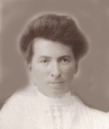
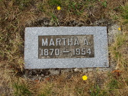
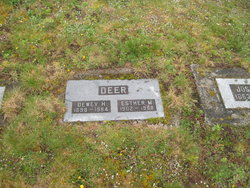
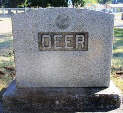
Martha Armilda Bennett Deer
| Birth | : | 17 Jan 1870 Nodaway County, Missouri, USA |
| Death | : | 29 Jul 1954 Shelton, Mason County, Washington, USA |
| Burial | : | St. Margaret's Churchyard, Drayton, Broadland District, England |
| Coordinate | : | 52.6773010, 1.2241980 |
| Plot | : | Moriah 22A-9418 |
| Description | : | WA--Shelton-MasonCnty Journal..05 Aug 1954 MARTHA A DEER, 84, A Shelton resident for 61yrs; died last Thursday Jul 29th in a Shelton hospital after an illness of 2 years. MrsDeer, extremely active in community affairs, was well known & deeply respected in this area. She was born 17 Jan 1870, in Maryville MO. She moved as a young woman to Tenino with her 2 brothers. She was wed to JosephH Deer & the family home was started on Franklin street in 1893. Mr&Mrs Deer & children moved in 1901 to a home on Oakland Bay. Joseph Deer, until his death in 1924,... Read More |
frequently asked questions (FAQ):
-
Where is Martha Armilda Bennett Deer's memorial?
Martha Armilda Bennett Deer's memorial is located at: St. Margaret's Churchyard, Drayton, Broadland District, England.
-
When did Martha Armilda Bennett Deer death?
Martha Armilda Bennett Deer death on 29 Jul 1954 in Shelton, Mason County, Washington, USA
-
Where are the coordinates of the Martha Armilda Bennett Deer's memorial?
Latitude: 52.6773010
Longitude: 1.2241980
Family Members:
Parent
Spouse
Siblings
Children

Flowers:


Nearby Cemetories:
1. St. Margaret's Churchyard
Drayton, Broadland District, England
Coordinate: 52.6773010, 1.2241980
2. St. Edmund's Churchyard
Costessey, South Norfolk District, England
Coordinate: 52.6660400, 1.2183410
3. St. Edmund's Churchyard
Taverham, Broadland District, England
Coordinate: 52.6789990, 1.1949460
4. Costessey Baptist Churchyard
Costessey, South Norfolk District, England
Coordinate: 52.6600122, 1.2116993
5. Our Lady & St. Walstan Churchyard
Costessey, South Norfolk District, England
Coordinate: 52.6583200, 1.2119300
6. All Saints Churchyard
Horsford, Broadland District, England
Coordinate: 52.6913720, 1.2494360
7. Costessey Parish Cemetery
Costessey, South Norfolk District, England
Coordinate: 52.6495927, 1.2040157
8. St. Mary's New Burial Ground
Hellesdon, Broadland District, England
Coordinate: 52.6495480, 1.2520370
9. Horsham St. Faith cemetery
Horsham St Faith, Broadland District, England
Coordinate: 52.6870250, 1.2758110
10. St. Mary's Churchyard
Hellesdon, Broadland District, England
Coordinate: 52.6486720, 1.2515280
11. St Margaret Churchyard
Felthorpe, Broadland District, England
Coordinate: 52.7099700, 1.2105700
12. St. Mary and St. Andrew Churchyard
Horsham St Faith, Broadland District, England
Coordinate: 52.6880970, 1.2771330
13. Horsham St. Faith Priory
Horsham St Faith, Broadland District, England
Coordinate: 52.6888310, 1.2783290
14. St Faith Crematorium
Horsham St Faith, Broadland District, England
Coordinate: 52.6967970, 1.2817680
15. Baptist Chapel Churchyard
Felthorpe, Broadland District, England
Coordinate: 52.7150000, 1.2008950
16. St Michael's Church
Bowthorpe, City of Norwich, England
Coordinate: 52.6359300, 1.2163600
17. St. Peter's Churchyard
Ringland, Broadland District, England
Coordinate: 52.6822900, 1.1552400
18. Old Catton Churchyard
Norwich, City of Norwich, England
Coordinate: 52.6627000, 1.2969770
19. St. Margaret's Churchyard
Catton, Broadland District, England
Coordinate: 52.6626280, 1.2970190
20. St. Bartholomew's Churchyard Heigham
Norwich, City of Norwich, England
Coordinate: 52.6401560, 1.2743680
21. St. Mary's Churchyard
Earlham, City of Norwich, England
Coordinate: 52.6280416, 1.2353034
22. St. Peter's Churchyard
Easton, South Norfolk District, England
Coordinate: 52.6543660, 1.1478070
23. St. Andrew Churchyard
Colney, South Norfolk District, England
Coordinate: 52.6253800, 1.2206100
24. St. Mary and St. Walstan Churchyard
Bawburgh, South Norfolk District, England
Coordinate: 52.6327480, 1.1796530