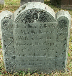
Martha Field Brown
| Birth | : | 1710 |
| Death | : | 19 Apr 1736 |
| Burial | : | Brotton Cemetery, Brotton, Redcar and Cleveland Unitary Authority, England |
| Coordinate | : | 54.5670800, -0.9310100 |
| Description | : | Parents: . William Field (1682 - 1729) . Martha Mathewson Marriage: . Joseph Brown, 1726 Children: 1. Gideon Brown Sr. (1728 - 1807) + sp: Ruth Rutenburg (1733 - 1787) 2. John Brown (b.1734) + sp: Sarah Harris (1737 - 1820) 3. Anna Brown (1735 - 1759) + sp: Benjamin Whipple III (1725 - 1803) |
frequently asked questions (FAQ):
-
Where is Martha Field Brown's memorial?
Martha Field Brown's memorial is located at: Brotton Cemetery, Brotton, Redcar and Cleveland Unitary Authority, England.
-
When did Martha Field Brown death?
Martha Field Brown death on 19 Apr 1736 in
-
Where are the coordinates of the Martha Field Brown's memorial?
Latitude: 54.5670800
Longitude: -0.9310100
Family Members:
Spouse
Flowers:
Nearby Cemetories:
1. Brotton Cemetery
Brotton, Redcar and Cleveland Unitary Authority, England
Coordinate: 54.5670800, -0.9310100
2. St. Margaret of Antioch Church Cemetery
Brotton, Redcar and Cleveland Unitary Authority, England
Coordinate: 54.5662700, -0.9305900
3. St Peter Churchyard
Brotton, Redcar and Cleveland Unitary Authority, England
Coordinate: 54.5679900, -0.9316200
4. St Margaret of Antioch Churchyard
Brotton, Redcar and Cleveland Unitary Authority, England
Coordinate: 54.5691380, -0.9358330
5. St Helen's
Carlin How, Redcar and Cleveland Unitary Authority, England
Coordinate: 54.5673410, -0.9024120
6. Skelton Cemetery
Skelton, Redcar and Cleveland Unitary Authority, England
Coordinate: 54.5604320, -0.9736353
7. St Leonard Churchyard
Loftus, Redcar and Cleveland Unitary Authority, England
Coordinate: 54.5532560, -0.8855250
8. St. Michael Churchyard
Liverton, Redcar and Cleveland Unitary Authority, England
Coordinate: 54.5370370, -0.9025160
9. Saltburn by the Sea Cemetery
Saltburn-by-the-Sea, Redcar and Cleveland Unitary Authority, England
Coordinate: 54.5808780, -0.9880640
10. Boosbeck Cemetery
Boosbeck, Redcar and Cleveland Unitary Authority, England
Coordinate: 54.5434900, -0.9779200
11. All Saints Old Churchyard
Skelton, Redcar and Cleveland Unitary Authority, England
Coordinate: 54.5623500, -0.9927600
12. St Aidan Churchyard
Boosbeck, Redcar and Cleveland Unitary Authority, England
Coordinate: 54.5428560, -0.9786800
13. Loftus Cemetery
Loftus, Redcar and Cleveland Unitary Authority, England
Coordinate: 54.5532380, -0.8716350
14. St Mary Churchyard
Moorsholm, Redcar and Cleveland Unitary Authority, England
Coordinate: 54.5207800, -0.9375800
15. All Saints Churchyard
Easington, Redcar and Cleveland Unitary Authority, England
Coordinate: 54.5520200, -0.8499800
16. St. Andrew's Old Churchyard
Upleatham, Redcar and Cleveland Unitary Authority, England
Coordinate: 54.5656900, -1.0164700
17. St. Germain Churchyard
Marske-by-the-Sea, Redcar and Cleveland Unitary Authority, England
Coordinate: 54.5946000, -1.0115200
18. St Nicholas Churchyard
Roxby, Scarborough Borough, England
Coordinate: 54.5365810, -0.8256590
19. Guisborough Cemetery
Guisborough, Redcar and Cleveland Unitary Authority, England
Coordinate: 54.5448330, -1.0430940
20. St. Nicholas Churchyard
Guisborough, Redcar and Cleveland Unitary Authority, England
Coordinate: 54.5366500, -1.0482800
21. Guisborough Priory
Guisborough, Redcar and Cleveland Unitary Authority, England
Coordinate: 54.5361700, -1.0489500
22. Quakers Burial Ground
Guisborough, Redcar and Cleveland Unitary Authority, England
Coordinate: 54.5355100, -1.0569760
23. St Peter Churchyard
Commondale, Scarborough Borough, England
Coordinate: 54.4863700, -0.9766200
24. Kirkleatham Memorial Park and Crematorium
Yearby, Redcar and Cleveland Unitary Authority, England
Coordinate: 54.5866300, -1.0753800


