
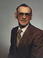

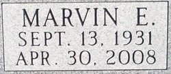
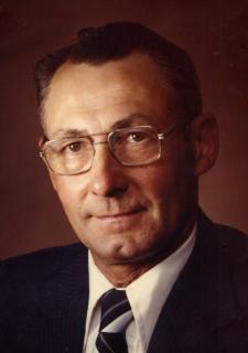
Marvin Edmond DePauw
| Birth | : | 13 Sep 1931 Hartwick, Poweshiek County, Iowa, USA |
| Death | : | 30 Apr 2008 Joplin, Newton County, Missouri, USA |
| Burial | : | Arnstein Cemetery, Arnstein, Parry Sound District, Canada |
| Coordinate | : | 45.9082100, -79.9174300 |
| Plot | : | Block XVII Lot 24 |
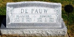
| Description | : | Marvin Edmond, DePauw, age, 76, of Galena KS, a former resident of Brooklyn, IA, died at 9:55 am, Wednesday, April 30, 2008 at St John's Regional Medical Center, Joplin, MO following an illness. Mr. DePauw was born September 13, 1931 in Hartwick, Iowa. His parents were Edmond and Blanche (Hendricks) DePauw. He had lived in Galena since 1985, moving from Brooklyn, Iowa. He was a truck driver for Ross Bennett Sand and Gravel Company, Galena, KS. In Brooklyn Iowa, he owned and operated DePauw Tiling Service for 18 years. He was a veteran of the Korean War serving in the US Army. Marvin... Read More |
frequently asked questions (FAQ):
-
Where is Marvin Edmond DePauw's memorial?
Marvin Edmond DePauw's memorial is located at: Arnstein Cemetery, Arnstein, Parry Sound District, Canada.
-
When did Marvin Edmond DePauw death?
Marvin Edmond DePauw death on 30 Apr 2008 in Joplin, Newton County, Missouri, USA
-
Where are the coordinates of the Marvin Edmond DePauw's memorial?
Latitude: 45.9082100
Longitude: -79.9174300
Family Members:
Parent

Spouse
Siblings
Children
Flowers:


Nearby Cemetories:
1. Arnstein Cemetery
Arnstein, Parry Sound District, Canada
Coordinate: 45.9082100, -79.9174300
2. Port and Loring Cemetery
Port Loring, Parry Sound District, Canada
Coordinate: 45.9200833, -79.9874667
3. St. Mary's Cemetery
Loring, Parry Sound District, Canada
Coordinate: 45.9357167, -79.9843667
4. Pioneer Cemetery
Loring, Parry Sound District, Canada
Coordinate: 45.9352167, -79.9869333
5. Golden Valley Cemetery
Golden Valley, Parry Sound District, Canada
Coordinate: 45.9251970, -79.8041630
6. Cedar Grove Cemetery
Restoule, Parry Sound District, Canada
Coordinate: 46.0254720, -79.7339640
7. Maple Island Cemetery
Maple Island, Parry Sound District, Canada
Coordinate: 45.6994100, -79.8725300
8. Ahmic Harbour Cemetery
Ahmic Harbour, Parry Sound District, Canada
Coordinate: 45.6623383, -79.7782211
9. Zion Lutheran Deer Lake Cemetery
Parry Sound, Parry Sound District, Canada
Coordinate: 45.7932440, -79.5596210
10. Barber Poineer Cemetery
Restoule, Parry Sound District, Canada
Coordinate: 46.0636100, -79.5771700
11. Chapman Community Cemetery
Chapman, Parry Sound District, Canada
Coordinate: 45.6943265, -79.6374739
12. Spence Community Cemetery
Spence, Parry Sound District, Canada
Coordinate: 45.6794395, -79.6414413
13. Dunchurch-Fairholme Cemetery
Dunchurch, Parry Sound District, Canada
Coordinate: 45.5963989, -79.9045702
14. Nipissing Union Cemetery
Nipissing, Nipissing District, Canada
Coordinate: 46.0894700, -79.5131200
15. Siloam Cemetery
South River, Parry Sound District, Canada
Coordinate: 45.8499800, -79.4176500
16. South River Cemetery
South River, Parry Sound District, Canada
Coordinate: 45.8359500, -79.3982400
17. Community Of Christ Cemetery
Nipissing District, Canada
Coordinate: 46.1780000, -80.2846667
18. Higher Heights Christian Fellowship Cemetery
South River, Parry Sound District, Canada
Coordinate: 45.8953070, -79.3786800
19. St. Aidan's Anglican Church Cemetery
Monetville, Sudbury District, Canada
Coordinate: 46.1775640, -80.2938640
20. Union Cemetery
Trout Creek, Parry Sound District, Canada
Coordinate: 45.9833200, -79.3768000
21. Strong Community Cemetery
Sundridge, Parry Sound District, Canada
Coordinate: 45.7767448, -79.4004288
22. Calvary Mennonite Cemetery
Monetville, Sudbury District, Canada
Coordinate: 46.1774530, -80.3119470
23. All Peoples Cemetery
Monetville, Sudbury District, Canada
Coordinate: 46.1620556, -80.3435000
24. Sacred Heart Cemetery
Trout Creek, Parry Sound District, Canada
Coordinate: 45.9979500, -79.3710000