

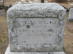
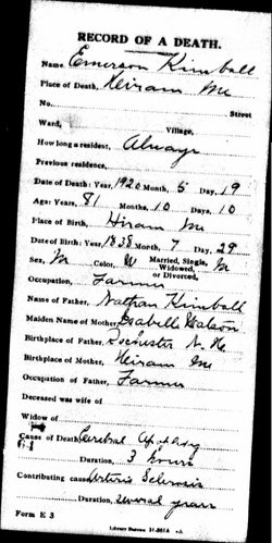
Mary A Kimball Wallace
| Birth | : | 10 Sep 1836 Hiram, Oxford County, Maine, USA |
| Death | : | 6 Mar 1912 Holderness, Grafton County, New Hampshire, USA |
| Burial | : | Thompson Cemetery, Sandwich, Carroll County, USA |
| Coordinate | : | 43.8014000, -71.5025000 |
frequently asked questions (FAQ):
-
Where is Mary A Kimball Wallace's memorial?
Mary A Kimball Wallace's memorial is located at: Thompson Cemetery, Sandwich, Carroll County, USA.
-
When did Mary A Kimball Wallace death?
Mary A Kimball Wallace death on 6 Mar 1912 in Holderness, Grafton County, New Hampshire, USA
-
Where are the coordinates of the Mary A Kimball Wallace's memorial?
Latitude: 43.8014000
Longitude: -71.5025000
Family Members:
Parent
Spouse
Siblings
Flowers:


Nearby Cemetories:
1. Thompson Cemetery
Sandwich, Carroll County, USA
Coordinate: 43.8014000, -71.5025000
2. Eastman Cemetery
Sandwich, Carroll County, USA
Coordinate: 43.7930300, -71.5263500
3. Chicks Corner Cemetery
Sandwich, Carroll County, USA
Coordinate: 43.8041000, -71.4728900
4. George Cemetery
Sandwich, Carroll County, USA
Coordinate: 43.7880560, -71.5338890
5. Israel Gilman Cemetery
Sandwich Landing, Carroll County, USA
Coordinate: 43.8268727, -71.4757671
6. Ladd Cemetery
Holderness, Grafton County, USA
Coordinate: 43.7873700, -71.5506400
7. Mount Delight Burying Ground
North Sandwich, Carroll County, USA
Coordinate: 43.8385671, -71.5158940
8. True Cemetery
Holderness, Grafton County, USA
Coordinate: 43.7819440, -71.5538890
9. Grove Cemetery
Sandwich, Carroll County, USA
Coordinate: 43.8101100, -71.4445200
10. Baptist Burial Ground
Center Sandwich, Carroll County, USA
Coordinate: 43.8079900, -71.4392600
11. Elm Hill Cemetery
Sandwich, Carroll County, USA
Coordinate: 43.8158330, -71.4338890
12. Elm Hill Cemetery
Center Sandwich, Carroll County, USA
Coordinate: 43.8158000, -71.4336000
13. Cemetery of the Religious Society of Friends
Sandwich, Carroll County, USA
Coordinate: 43.7994400, -71.4266700
14. Haines Cemetery
Union, Carroll County, USA
Coordinate: 43.7734000, -71.4331000
15. Mason Cemetery
Center Sandwich, Carroll County, USA
Coordinate: 43.7858000, -71.4258000
16. Smith-Morse Cemetery
Sandwich, Carroll County, USA
Coordinate: 43.7768000, -71.4301000
17. Moulton-Beede Cemetery
Sandwich, Carroll County, USA
Coordinate: 43.7774000, -71.4276000
18. Beede Cemetery
Sandwich, Carroll County, USA
Coordinate: 43.8013890, -71.4166670
19. Burleigh-Carr Cemetery
Holderness, Grafton County, USA
Coordinate: 43.7583600, -71.5675200
20. Campbell Cemetery
Center Harbor, Belknap County, USA
Coordinate: 43.7372686, -71.5012926
21. Cook Family Cemetery
Moultonborough, Carroll County, USA
Coordinate: 43.7435585, -71.4621048
22. Prescott Cemetery
Holderness, Grafton County, USA
Coordinate: 43.7546400, -71.5682400
23. Mason Cemetery
North Sandwich, Carroll County, USA
Coordinate: 43.8542000, -71.4426000
24. Littles Pond Cemetery
Sandwich, Carroll County, USA
Coordinate: 43.7915600, -71.4034200