
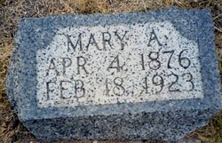
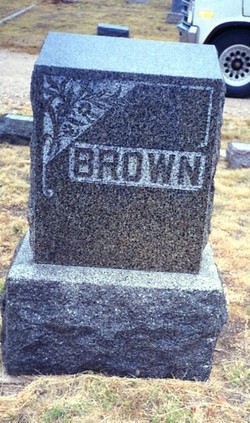
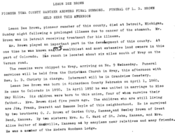
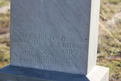
Mary Alina Ellis Brown
| Birth | : | 4 May 1876 Topeka, Shawnee County, Kansas, USA |
| Death | : | 18 Feb 1923 Wray, Yuma County, Colorado, USA |
| Burial | : | Saint John the Evangelist Churchyard, Oxborough, Breckland Borough, England |
| Coordinate | : | 52.5828040, 0.5727550 |
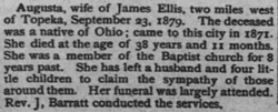
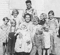
| Description | : | Parents James Henry and Augusta Elizabeth Prather Ellis Married Lemon Deacon Brown - 6 children |
frequently asked questions (FAQ):
-
Where is Mary Alina Ellis Brown's memorial?
Mary Alina Ellis Brown's memorial is located at: Saint John the Evangelist Churchyard, Oxborough, Breckland Borough, England.
-
When did Mary Alina Ellis Brown death?
Mary Alina Ellis Brown death on 18 Feb 1923 in Wray, Yuma County, Colorado, USA
-
Where are the coordinates of the Mary Alina Ellis Brown's memorial?
Latitude: 52.5828040
Longitude: 0.5727550
Family Members:
Parent
Spouse
Siblings
Children

Flowers:


Nearby Cemetories:
1. Saint John the Evangelist Churchyard
Oxborough, Breckland Borough, England
Coordinate: 52.5828040, 0.5727550
2. St George's Churchyard
Gooderstone, Breckland Borough, England
Coordinate: 52.5884010, 0.6003860
3. All Saints Churchyard
Foulden, Breckland Borough, England
Coordinate: 52.5599040, 0.6021930
4. St. Mary the Virgin Churchyard
Beachamwell, Breckland Borough, England
Coordinate: 52.6178670, 0.5844730
5. All Saints Churchyard
Stoke Ferry, Kings Lynn and West Norfolk Borough, England
Coordinate: 52.5702970, 0.5138070
6. All Saints Churchyard
Boughton, Kings Lynn and West Norfolk Borough, England
Coordinate: 52.5913020, 0.5080360
7. Northwold Cemetery
Northwold, Kings Lynn and West Norfolk Borough, England
Coordinate: 52.5419000, 0.5820000
8. St Andrew Churchyard
Northwold, Kings Lynn and West Norfolk Borough, England
Coordinate: 52.5425540, 0.5878920
9. St. Andrew's Old Cemetery
Northwold, Kings Lynn and West Norfolk Borough, England
Coordinate: 52.5405523, 0.5864157
10. St. Mary's Churchyard
Barton Bendish, Kings Lynn and West Norfolk Borough, England
Coordinate: 52.6198270, 0.5243860
11. St. Andrew's Churchyard
Barton Bendish, Kings Lynn and West Norfolk Borough, England
Coordinate: 52.6219270, 0.5277620
12. All Saints Churchyard
Cockley Cley, Breckland Borough, England
Coordinate: 52.6057860, 0.6446070
13. St. Margaret of Antioch Churchyard
Wereham, Kings Lynn and West Norfolk Borough, England
Coordinate: 52.5867700, 0.4799200
14. Methwold Cemetery
Methwold, Kings Lynn and West Norfolk Borough, England
Coordinate: 52.5257758, 0.5575197
15. St. George's Churchyard
Methwold, Kings Lynn and West Norfolk Borough, England
Coordinate: 52.5229060, 0.5568700
16. St Martin's Churchyard
Fincham, Kings Lynn and West Norfolk Borough, England
Coordinate: 52.6296100, 0.4926900
17. St Mary's Churchyard
Cranwich, Breckland Borough, England
Coordinate: 52.5224040, 0.6262310
18. St. Andrew's Churchyard
West Dereham, Kings Lynn and West Norfolk Borough, England
Coordinate: 52.5911080, 0.4599020
19. All Saints Churchyard
Hilborough, Breckland Borough, England
Coordinate: 52.5673800, 0.6921240
20. St. Mary's Churchyard
Stradsett, Kings Lynn and West Norfolk Borough, England
Coordinate: 52.6178500, 0.4588500
21. Holy Trinity Churchyard
Marham, Kings Lynn and West Norfolk Borough, England
Coordinate: 52.6583800, 0.5236900
22. St. Mary's Churchyard
Bodney, Breckland Borough, England
Coordinate: 52.5561990, 0.7002570
23. Marham Cemetery
Marham, Kings Lynn and West Norfolk Borough, England
Coordinate: 52.6622260, 0.5287110
24. St Leonard's Churchyard
Mundford, Breckland Borough, England
Coordinate: 52.5125080, 0.6521150