
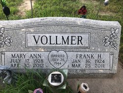
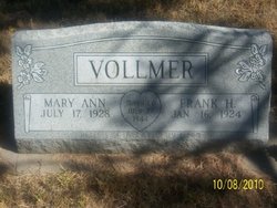
Mary Ann “Macky” Klauz Vollmer
| Birth | : | 17 Jul 1928 Omaha, Douglas County, Nebraska, USA |
| Death | : | 30 Apr 2012 Lexington, Dawson County, Nebraska, USA |
| Burial | : | St Peter's Churchyard, Carlton Colville, Waveney District, England |
| Coordinate | : | 52.4514530, 1.6929030 |
| Description | : | Marian "Macky" Vollmer (July 17, 1928 - April 30, 2012) Marian "Macky" Vollmer, 83, of Lexington, Nebraska, passed away Monday, April 30, 2012, at Lexington Regional Health Center in Lexington. She was born July 17, 1928, in Omaha, Nebraska. She grew up in Clay County and attended school in Edgar, Nebraska. In 1943, she moved to Dawson County with her family. On July 24, 1944, she married Frank Vollmer. They were blessed with three children, Larry, Bev, and Pam. Macky was employed at Parkway Café, Maloley Grocery Store, and Pamida.... Read More |
frequently asked questions (FAQ):
-
Where is Mary Ann “Macky” Klauz Vollmer's memorial?
Mary Ann “Macky” Klauz Vollmer's memorial is located at: St Peter's Churchyard, Carlton Colville, Waveney District, England.
-
When did Mary Ann “Macky” Klauz Vollmer death?
Mary Ann “Macky” Klauz Vollmer death on 30 Apr 2012 in Lexington, Dawson County, Nebraska, USA
-
Where are the coordinates of the Mary Ann “Macky” Klauz Vollmer's memorial?
Latitude: 52.4514530
Longitude: 1.6929030
Family Members:
Parent
Spouse

Flowers:


Nearby Cemetories:
1. St Peter's Churchyard
Carlton Colville, Waveney District, England
Coordinate: 52.4514530, 1.6929030
2. St Peter's New Churchyard
Carlton Colville, Waveney District, England
Coordinate: 52.4528500, 1.6953250
3. Holy Trinity Churchyard
Gisleham, Waveney District, England
Coordinate: 52.4372320, 1.6975344
4. St. Michael's Churchyard
Rushmere, Waveney District, England
Coordinate: 52.4332200, 1.6688300
5. All Saints & St Margaret Churchyard
Pakefield, Waveney District, England
Coordinate: 52.4533520, 1.7344150
6. St. Andrew's Churchyard
Mutford, Waveney District, England
Coordinate: 52.4387060, 1.6566540
7. Saint John the Baptist Churchyard
Barnby, Waveney District, England
Coordinate: 52.4510410, 1.6494740
8. Kirkley Cemetery
Lowestoft, Waveney District, England
Coordinate: 52.4583260, 1.7353110
9. St. Peter and St. John Churchyard
Kirkley, Waveney District, England
Coordinate: 52.4628290, 1.7384010
10. St. Michael's Churchyard
Oulton, Waveney District, England
Coordinate: 52.4823570, 1.6952900
11. St Mary's Churchyard
Burgh St Peter, South Norfolk District, England
Coordinate: 52.4840860, 1.6710830
12. St Edmund Churchyard
Kessingland, Waveney District, England
Coordinate: 52.4158970, 1.7157750
13. St Mary Churchyard
Henstead, Waveney District, England
Coordinate: 52.4159800, 1.6577200
14. Lowestoft Cemetery
Lowestoft, Waveney District, England
Coordinate: 52.4814390, 1.7404560
15. St. Botolph Churchyard
North Cove, Waveney District, England
Coordinate: 52.4474411, 1.6227847
16. St Margaret Churchyard
Lowestoft, Waveney District, England
Coordinate: 52.4860970, 1.7402750
17. St. Michael's Churchyard
Benacre, Waveney District, England
Coordinate: 52.4003900, 1.6907680
18. Waveney Memorial Park and Crematorium
Ellough, Waveney District, England
Coordinate: 52.4314090, 1.6151750
19. Wrentham Municipal Cemetery
Wrentham, Waveney District, England
Coordinate: 52.4020520, 1.6676040
20. Lowestoft Naval Memorial
Lowestoft, Waveney District, England
Coordinate: 52.4883730, 1.7554520
21. RNPS Belle Vue Park Cemetery
Lowestoft, Waveney District, England
Coordinate: 52.4901740, 1.7559862
22. St. Peter's Churchyard
Gunton, Waveney District, England
Coordinate: 52.5003000, 1.7444000
23. All Saints Churchyard
Worlingham, Waveney District, England
Coordinate: 52.4517300, 1.5969000
24. Gunton Woodland Burial Park
Lowestoft, Waveney District, England
Coordinate: 52.5010260, 1.7461380