
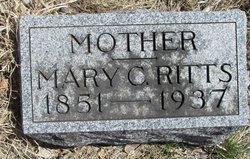
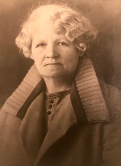
Mary Catherine Redmond Ritts
| Birth | : | 21 Feb 1851 Wisconsin, USA |
| Death | : | 1937 Washta, Cherokee County, Iowa, USA |
| Burial | : | Holy Sepulchre Cemetery, Omaha, Douglas County, USA |
| Coordinate | : | 41.2543983, -95.9875031 |
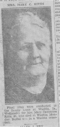
| Description | : | MRS. MARY C. RITTS Final rites were conducted in the family home at Washta, Ia., Wednesday for Mrs. Mary Catherine Ritts, 86, who died at Washta Monday. Burial was in a Washta cemetery. Mrs. Ritts was the daughter of: Thomas and Jane Redman. She was born in Wisconsin February 21, 1851. When a small child she moved with her parents to Iowa. She spent 70 years of her life in Iowa, all but two of which were in Cherokee county. She was married to Daniel Ritts at New Hampton, Ia., October 10, 1866. Mr. Ritts preceded her in death as did four of... Read More |
frequently asked questions (FAQ):
-
Where is Mary Catherine Redmond Ritts's memorial?
Mary Catherine Redmond Ritts's memorial is located at: Holy Sepulchre Cemetery, Omaha, Douglas County, USA.
-
When did Mary Catherine Redmond Ritts death?
Mary Catherine Redmond Ritts death on 1937 in Washta, Cherokee County, Iowa, USA
-
Where are the coordinates of the Mary Catherine Redmond Ritts's memorial?
Latitude: 41.2543983
Longitude: -95.9875031
Family Members:
Spouse
Children


Flowers:


Nearby Cemetories:
1. Holy Sepulchre Cemetery
Omaha, Douglas County, USA
Coordinate: 41.2543983, -95.9875031
2. Douglas County Poor Farm Cemetery
Omaha, Douglas County, USA
Coordinate: 41.2437240, -95.9723480
3. First Central Congregational Columbarium
Omaha, Douglas County, USA
Coordinate: 41.2563456, -95.9658365
4. Bohemian Cemetery
Omaha, Douglas County, USA
Coordinate: 41.2388992, -95.9955978
5. Nash Chapel Crypt
Omaha, Douglas County, USA
Coordinate: 41.2665090, -95.9721790
6. Westlawn-Hillcrest Memorial Park
Omaha, Douglas County, USA
Coordinate: 41.2346992, -95.9966965
7. Ak-Sar-Ben Racetrack Grounds
Omaha, Douglas County, USA
Coordinate: 41.2414703, -96.0159607
8. Prospect Hill Cemetery
Omaha, Douglas County, USA
Coordinate: 41.2780991, -95.9593964
9. Calvary Cemetery
Omaha, Douglas County, USA
Coordinate: 41.2364006, -96.0294037
10. Trinity Cathedral Columbarium
Omaha, Douglas County, USA
Coordinate: 41.2603900, -95.9393660
11. Evergreen Memorial Park Cemetery
Omaha, Douglas County, USA
Coordinate: 41.2393990, -96.0355988
12. Saint Andrews Episcopal Church Columbarium
Omaha, Douglas County, USA
Coordinate: 41.2492500, -96.0427500
13. Resurrection Cemetery
Omaha, Douglas County, USA
Coordinate: 41.2344208, -96.0365448
14. Graceland Park Cemetery
Omaha, Douglas County, USA
Coordinate: 41.2113991, -95.9785995
15. Countryside Community Church Columbarium
Omaha, Douglas County, USA
Coordinate: 41.2483660, -96.0500270
16. Saint Mary Magdalene Cemetery
Omaha, Douglas County, USA
Coordinate: 41.2039420, -95.9850610
17. Golden Hill Cemetery
Omaha, Douglas County, USA
Coordinate: 41.3050003, -95.9744034
18. Saint Mary's Cemetery
Omaha, Douglas County, USA
Coordinate: 41.2042007, -95.9646988
19. Servants of Mary Cemetery
Omaha, Douglas County, USA
Coordinate: 41.3017170, -96.0258260
20. All Saints Episcopal Church Columbarium
Omaha, Douglas County, USA
Coordinate: 41.2785000, -96.0579000
21. Springwell Cemetery
Omaha, Douglas County, USA
Coordinate: 41.3114014, -96.0096970
22. Beth El Cemetery
Ralston, Douglas County, USA
Coordinate: 41.2117004, -96.0428009
23. Mount Hope Cemetery
Omaha, Douglas County, USA
Coordinate: 41.3041992, -96.0310974
24. Pleasant Hill Jewish Cemetery
Omaha, Douglas County, USA
Coordinate: 41.3185997, -95.9766998