

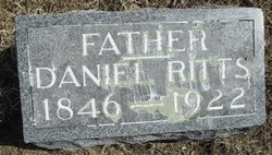
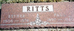
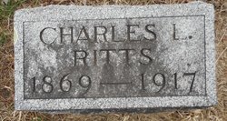
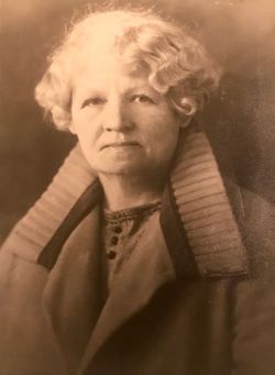
Paul Harlen Ritts
| Birth | : | 28 Aug 1897 Washta, Cherokee County, Iowa, USA |
| Death | : | 21 Sep 1980 Washta, Cherokee County, Iowa, USA |
| Burial | : | Holy Sepulchre Cemetery, Omaha, Douglas County, USA |
| Coordinate | : | 41.2543983, -95.9875031 |
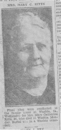
| Description | : | SPOUSE 1: Esther Elizabeth Box Married Nov. 7, 1924 - Humboldt Co., Iowa ===================== Cherokee Daily Times, Cherokee, IA September 22, 1980 Page 2 WASHTA — Paul Ritts, 83, of Washta died Sunday at his home due to a heart condition. He had been a resident here his entire life. Mr. Ritts was born Aug. 28, 1897, at Washta. On May 30, 1942, he married Esther England Shepherd at Fremont, Neb. He owned and operated a barber shop in Washta for 50 years, was a member of the United Methodist Church and a veteran of World War I. Survivors include a stepson, Richard Shepherd,... Read More |
frequently asked questions (FAQ):
-
Where is Paul Harlen Ritts's memorial?
Paul Harlen Ritts's memorial is located at: Holy Sepulchre Cemetery, Omaha, Douglas County, USA.
-
When did Paul Harlen Ritts death?
Paul Harlen Ritts death on 21 Sep 1980 in Washta, Cherokee County, Iowa, USA
-
Where are the coordinates of the Paul Harlen Ritts's memorial?
Latitude: 41.2543983
Longitude: -95.9875031
Family Members:
Parent
Spouse
Siblings


Flowers:


Nearby Cemetories:
1. Holy Sepulchre Cemetery
Omaha, Douglas County, USA
Coordinate: 41.2543983, -95.9875031
2. Douglas County Poor Farm Cemetery
Omaha, Douglas County, USA
Coordinate: 41.2437240, -95.9723480
3. First Central Congregational Columbarium
Omaha, Douglas County, USA
Coordinate: 41.2563456, -95.9658365
4. Bohemian Cemetery
Omaha, Douglas County, USA
Coordinate: 41.2388992, -95.9955978
5. Nash Chapel Crypt
Omaha, Douglas County, USA
Coordinate: 41.2665090, -95.9721790
6. Westlawn-Hillcrest Memorial Park
Omaha, Douglas County, USA
Coordinate: 41.2346992, -95.9966965
7. Ak-Sar-Ben Racetrack Grounds
Omaha, Douglas County, USA
Coordinate: 41.2414703, -96.0159607
8. Prospect Hill Cemetery
Omaha, Douglas County, USA
Coordinate: 41.2780991, -95.9593964
9. Calvary Cemetery
Omaha, Douglas County, USA
Coordinate: 41.2364006, -96.0294037
10. Trinity Cathedral Columbarium
Omaha, Douglas County, USA
Coordinate: 41.2603900, -95.9393660
11. Evergreen Memorial Park Cemetery
Omaha, Douglas County, USA
Coordinate: 41.2393990, -96.0355988
12. Saint Andrews Episcopal Church Columbarium
Omaha, Douglas County, USA
Coordinate: 41.2492500, -96.0427500
13. Resurrection Cemetery
Omaha, Douglas County, USA
Coordinate: 41.2344208, -96.0365448
14. Graceland Park Cemetery
Omaha, Douglas County, USA
Coordinate: 41.2113991, -95.9785995
15. Countryside Community Church Columbarium
Omaha, Douglas County, USA
Coordinate: 41.2483660, -96.0500270
16. Saint Mary Magdalene Cemetery
Omaha, Douglas County, USA
Coordinate: 41.2039420, -95.9850610
17. Golden Hill Cemetery
Omaha, Douglas County, USA
Coordinate: 41.3050003, -95.9744034
18. Saint Mary's Cemetery
Omaha, Douglas County, USA
Coordinate: 41.2042007, -95.9646988
19. Servants of Mary Cemetery
Omaha, Douglas County, USA
Coordinate: 41.3017170, -96.0258260
20. All Saints Episcopal Church Columbarium
Omaha, Douglas County, USA
Coordinate: 41.2785000, -96.0579000
21. Springwell Cemetery
Omaha, Douglas County, USA
Coordinate: 41.3114014, -96.0096970
22. Beth El Cemetery
Ralston, Douglas County, USA
Coordinate: 41.2117004, -96.0428009
23. Mount Hope Cemetery
Omaha, Douglas County, USA
Coordinate: 41.3041992, -96.0310974
24. Pleasant Hill Jewish Cemetery
Omaha, Douglas County, USA
Coordinate: 41.3185997, -95.9766998