
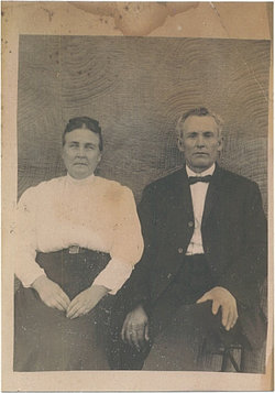
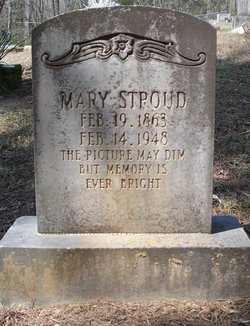
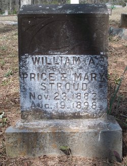
Mary Driver Stroud
| Birth | : | 19 Feb 1862 Van Buren County, Arkansas, USA |
| Death | : | 14 Feb 1948 Van Buren County, Arkansas, USA |
| Burial | : | Memory Gardens, Madison, Boone County, USA |
| Coordinate | : | 38.0281200, -81.8340700 |
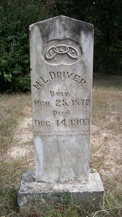
| Description | : | Mary Driver Stroud was the daughter of William Matthew Driver and Armintha Hardy Driver. Mary married Price Stroud on February 2, 1853 in Van Buren Co., Arkansas. The Liberty Springs Cemetery was established on the farm land where they lived. On May 14, 1927 Mary donated the portion of the land occupied by the church and cemetery. The beginning portion of the legal document started as follows: "RECORD OF DEED OF LIBERTY SPRINGS CHURCH OF CHRIST, State of Arkansas, County of Van Buren: Know all men by these presents that I, Mary Stroud of the County... Read More |
frequently asked questions (FAQ):
-
Where is Mary Driver Stroud's memorial?
Mary Driver Stroud's memorial is located at: Memory Gardens, Madison, Boone County, USA.
-
When did Mary Driver Stroud death?
Mary Driver Stroud death on 14 Feb 1948 in Van Buren County, Arkansas, USA
-
Where are the coordinates of the Mary Driver Stroud's memorial?
Latitude: 38.0281200
Longitude: -81.8340700
Family Members:
Parent


Spouse

Siblings

Children

Flowers:


Nearby Cemetories:
1. Memory Gardens
Madison, Boone County, USA
Coordinate: 38.0281200, -81.8340700
2. Burwell Ballard Cemetery
Low Gap, Boone County, USA
Coordinate: 38.0280310, -81.8344330
3. Caldwell Cemetery
Madison, Boone County, USA
Coordinate: 38.0261490, -81.8324140
4. Family Gardens Cemetery
Low Gap, Boone County, USA
Coordinate: 38.0272700, -81.8311300
5. Allen Cemetery
Low Gap, Boone County, USA
Coordinate: 38.0307190, -81.8331730
6. Miller Cemetery
Low Gap, Boone County, USA
Coordinate: 38.0193700, -81.8519700
7. Boone Memorial Park
Madison, Boone County, USA
Coordinate: 38.0484630, -81.8312900
8. Bias Cemetery
Boone County, USA
Coordinate: 38.0175018, -81.8660965
9. Price Cemetery
Danville, Boone County, USA
Coordinate: 38.0402985, -81.8022003
10. Bias Cemetery
Low Gap, Boone County, USA
Coordinate: 38.0175300, -81.8670600
11. George Price Cemetery
Foch, Boone County, USA
Coordinate: 38.0404820, -81.8018790
12. Canterbury Cemetery
Low Gap, Boone County, USA
Coordinate: 38.0176900, -81.8674000
13. Allen Cemetery
Madison, Boone County, USA
Coordinate: 38.0569800, -81.8271800
14. Rufus C. Ball Cemetery
Greenview, Boone County, USA
Coordinate: 38.0000100, -81.8471200
15. Ball Cemetery
Boone County, USA
Coordinate: 37.9996986, -81.8469009
16. Danville Memorial Park
Danville, Boone County, USA
Coordinate: 38.0313750, -81.8721900
17. Floyd Miller Cemetery
Danville, Boone County, USA
Coordinate: 38.0197780, -81.8714420
18. Robert C. Ball Cemetery
Greenview, Boone County, USA
Coordinate: 37.9998400, -81.8504300
19. Stollings Cemetery
Madison, Boone County, USA
Coordinate: 38.0586300, -81.8225200
20. Kentucky Knoll Cemetery
Boone County, USA
Coordinate: 37.9977989, -81.8197021
21. Pauley Family Cemetery
Greenview, Boone County, USA
Coordinate: 37.9991989, -81.8542023
22. South Madison Cemetery
Madison, Boone County, USA
Coordinate: 38.0583649, -81.8172455
23. Smoot Cemetery
Madison, Boone County, USA
Coordinate: 38.0594501, -81.8204875
24. Powell Cemetery
Greenview, Boone County, USA
Coordinate: 37.9944000, -81.8233032