
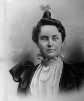
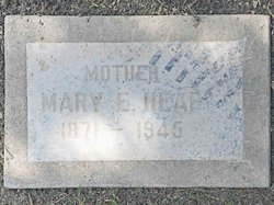
Mary Elizabeth Dempsey Heap
| Birth | : | 20 Oct 1870 Santa Barbara, Santa Barbara County, California, USA |
| Death | : | 28 Jan 1945 San Bernardino, San Bernardino County, California, USA |
| Burial | : | Bethlehem Cemetery, Grantsville, Calhoun County, USA |
| Coordinate | : | 38.9124985, -81.0841980 |
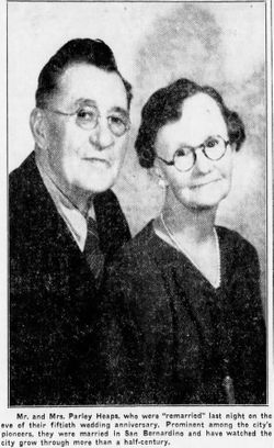
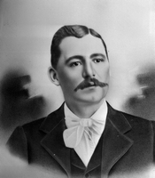
| Description | : | Daughter of and Susannah Mapstead Wallace(1850–1914) Married to Parley Whitaker Heap |
frequently asked questions (FAQ):
-
Where is Mary Elizabeth Dempsey Heap's memorial?
Mary Elizabeth Dempsey Heap's memorial is located at: Bethlehem Cemetery, Grantsville, Calhoun County, USA.
-
When did Mary Elizabeth Dempsey Heap death?
Mary Elizabeth Dempsey Heap death on 28 Jan 1945 in San Bernardino, San Bernardino County, California, USA
-
Where are the coordinates of the Mary Elizabeth Dempsey Heap's memorial?
Latitude: 38.9124985
Longitude: -81.0841980
Family Members:
Parent
Spouse
Siblings
Children
Flowers:


Nearby Cemetories:
1. Bethlehem Cemetery
Grantsville, Calhoun County, USA
Coordinate: 38.9124985, -81.0841980
2. Betts Cemetery
Calhoun County, USA
Coordinate: 38.9303017, -81.1153030
3. Pleasant Hill Cemetery
Grantsville, Calhoun County, USA
Coordinate: 38.9508018, -81.0627975
4. Saint Paul Cemetery
Grantsville, Calhoun County, USA
Coordinate: 38.8770000, -81.1275000
5. Saint Paul Cemetery
Mount Zion, Calhoun County, USA
Coordinate: 38.8768997, -81.1278000
6. Hunt Cemetery
Bigbend, Calhoun County, USA
Coordinate: 38.9573700, -81.1239100
7. Bethel-Bennett-Burns Cemetery
Grantsville, Calhoun County, USA
Coordinate: 38.9022000, -81.0153000
8. Broomstick Cemetery
Calhoun County, USA
Coordinate: 38.9668999, -81.0911026
9. Mount Zion Cemetery
Grantsville, Calhoun County, USA
Coordinate: 38.8605995, -81.1256027
10. Roling Cemetery
Calhoun County, USA
Coordinate: 38.8521996, -81.0702972
11. Norman Ridge United Methodist Church Cemetery
Calhoun County, USA
Coordinate: 38.9687900, -81.1175100
12. Yoak Cemetery
Five Forks, Calhoun County, USA
Coordinate: 38.9703865, -81.1154938
13. Bennett Cemetery
Calhoun County, USA
Coordinate: 38.8636017, -81.0314026
14. Bryners Chapel Cemetery
Joker, Calhoun County, USA
Coordinate: 38.9033012, -81.1703033
15. Ayers Cemetery
Latonia, Gilmer County, USA
Coordinate: 38.9422222, -81.0058333
16. Taylor Cemetery
Bigbend, Calhoun County, USA
Coordinate: 38.9801760, -81.1199320
17. Big Springs Cemetery
Big Springs, Calhoun County, USA
Coordinate: 38.9850006, -81.0708008
18. Hur Cemetery
Calhoun County, USA
Coordinate: 38.8741989, -81.1686020
19. Knight Cemetery
Big Springs, Calhoun County, USA
Coordinate: 38.9894000, -81.0800000
20. Chestnut Grove Baptist Church Cemetery
Gilmer County, USA
Coordinate: 38.9340420, -80.9885860
21. Nobe Cemetery
Nobe, Calhoun County, USA
Coordinate: 38.9813000, -81.0380300
22. Barr Cemetery
Calhoun County, USA
Coordinate: 38.8274994, -81.0924988
23. Stump Cemetery
Stumptown, Gilmer County, USA
Coordinate: 38.8495000, -81.0030000
24. Trace Fork United Methodist Church Cemetery
Gilmer County, USA
Coordinate: 38.9743580, -81.0005560