
| Birth | : | 22 Feb 1871 Blandinsville, McDonough County, Illinois, USA |
| Death | : | 20 Aug 1936 Clarke County, Iowa, USA |
| Burial | : | Basford Cemetery, Old Basford, Nottingham Unitary Authority, England |
| Coordinate | : | 52.9799700, -1.1725900 |
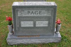
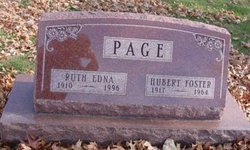
| Description | : | The Osceola Tribune, Osceola, Iowa August 25, 1936, Page 6 Mary Elizabeth Mustain Page Known to her friends as Mollie Mary Elizabeth, oldest daughter of Nathan and Almeda Page Mustain, was born February 22nd, 1871, near Blandinsville, Illinois, and her home until sixteen years of age, departed this life on the twentieth day of August 1936, at her home south of Osceola, Iowa, at the age of 65 years, 5 months and 28 days. On the 27th day of August 1902, she was united in marriage to Silas Elmer Page. Mrs. Page was the loving mother... Read More |
frequently asked questions (FAQ):
-
Where is Mary Elizabeth “Mollie” Mustain Page's memorial?
Mary Elizabeth “Mollie” Mustain Page's memorial is located at: Basford Cemetery, Old Basford, Nottingham Unitary Authority, England.
-
When did Mary Elizabeth “Mollie” Mustain Page death?
Mary Elizabeth “Mollie” Mustain Page death on 20 Aug 1936 in Clarke County, Iowa, USA
-
Where are the coordinates of the Mary Elizabeth “Mollie” Mustain Page's memorial?
Latitude: 52.9799700
Longitude: -1.1725900
Family Members:
Parent

Spouse
Siblings
Children
Flowers:


Nearby Cemetories:
1. Basford Cemetery
Old Basford, Nottingham Unitary Authority, England
Coordinate: 52.9799700, -1.1725900
2. St. Leodegarius Churchyard
Old Basford, Nottingham Unitary Authority, England
Coordinate: 52.9794240, -1.1778650
3. St. John's Carrington Churchyard
Nottingham, Nottingham Unitary Authority, England
Coordinate: 52.9755350, -1.1506790
4. Nottingham Church Cemetery
Nottingham, Nottingham Unitary Authority, England
Coordinate: 52.9649830, -1.1558070
5. Hardy Street Jewish Cemetery
Nottingham, Nottingham Unitary Authority, England
Coordinate: 52.9619500, -1.1665900
6. St. Peter Churchyard Old Radford
Nottingham, Nottingham Unitary Authority, England
Coordinate: 52.9601830, -1.1789620
7. Nottingham General Cemetery
Nottingham, Nottingham Unitary Authority, England
Coordinate: 52.9575370, -1.1594236
8. General Cemetery
Nottingham, Nottingham Unitary Authority, England
Coordinate: 52.9561430, -1.1615420
9. Cathedral Church of St. Barnabas
Nottingham, Nottingham Unitary Authority, England
Coordinate: 52.9546750, -1.1570460
10. Northern Cemetery
Bulwell, Nottingham Unitary Authority, England
Coordinate: 52.9979840, -1.2077900
11. St. Mary Rest Ground
Nottingham, Nottingham Unitary Authority, England
Coordinate: 52.9568310, -1.1406580
12. St Peters Church Yard
Nottingham, Nottingham Unitary Authority, England
Coordinate: 52.9522800, -1.1486940
13. Holy Trinity Churchyard
Lenton, Nottingham Unitary Authority, England
Coordinate: 52.9485630, -1.1753148
14. St Nicholas Churchyard
Nottingham, Nottingham Unitary Authority, England
Coordinate: 52.9504780, -1.1509220
15. St Mary's Burial Grounds
Nottingham, Nottingham Unitary Authority, England
Coordinate: 52.9527860, -1.1419160
16. National Justice Museum High Pavement Nottingham
Nottingham Unitary Authority, England
Coordinate: 52.9510680, -1.1443050
17. National Ice Centre
Nottingham, Nottingham Unitary Authority, England
Coordinate: 52.9527790, -1.1394460
18. Redhill Cemetery
Arnold, Nottingham Unitary Authority, England
Coordinate: 53.0066910, -1.1382950
19. St. Paul's Churchyard
Nottingham Unitary Authority, England
Coordinate: 52.9667590, -1.1172140
20. St. Leonard's Churchyard
Wollaton, Nottingham Unitary Authority, England
Coordinate: 52.9529790, -1.2200830
21. Wollaton Cemetery
Wollaton, Nottingham Unitary Authority, England
Coordinate: 52.9503000, -1.2260800
22. All Saints Church
Strelley, Broxtowe Borough, England
Coordinate: 52.9737900, -1.2470340
23. St. Wilfrid Churchyard
Wilford, Nottingham Unitary Authority, England
Coordinate: 52.9346290, -1.1587770
24. Wilford Village Cemetery
Wilford, Nottingham Unitary Authority, England
Coordinate: 52.9338540, -1.1591170